
7 Ways to Make the Longer Days Easier
The Bibbulmun is an excellent track for thru hiking at your own pace (See "The Best Long Distance Wildflower Walk for Slower Hikers” to understand why). In many cases there are options to shorten or lengthen days to suit your own walking rhythm and time frames, and many of these options are available on other hikes, too. The important thing is to recognise that you are not locked into the “official” schedule, and legal alternatives may make the hike more suitable for you.
Distances between huts on the Bibbulmun vary significantly, typically between 12 to 20 km. A handful of huts have less than 10 km between them, but around one third of the huts are over 20 km apart. Here’s that graph of daily distances and the number of days for each daily distance.

Total distance is not the only story: elevation gain is at least as important for us, and temperature.
Nevertheless, you can see from the graph that the standard hut-to-hut walk involves a significant number of longer days. But it need not be like that for all of them.

The table identifies the days I consider the most obvious and beneficial to consider breaking up.
And below are suggestions for how to split some of these days, remembering that what is a hard section one day may be easier on another if it is not as wet or hot. Many of the options require a track transfer, but fortunately many excellent companies support Bibbulmun track hikers.
Our 7 Ways to Ease the Day
There are at least seven ways in which you can make a day easier.
1. Camp Between Huts
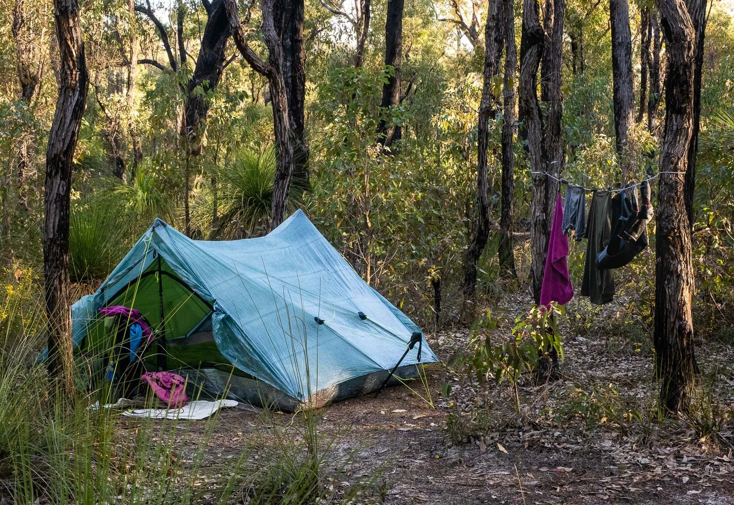
The options for camping between huts are limited on the Bibbulmun because much of it is through water supply catchment areas, Conservation Parks or Nature Reserves, where camping is prohibited. Nevertheless some options are possible and legal. Whilst not particularly “wild”, Willows Springs and Greens Island are two examples where we applied this approach. Other hikes have many more intermediate options.

Delightful Willow Springs (aka Davies) campsite.
2. Accommodation between Huts
A number of our fellow hikers did this to good effect and it’s something we’ll consider next time. We think we’ve captured the most beneficial ones in our section by section descriptions below.
3. Transport to collect and drop you between huts.
There are less than a handful of days where this isn’t practicable. There are two approaches.
The Bibbulmun Track has many road access points where track transfer operators can collect and drop you back. Therefore, many of the longer days can be split approximately in half using this technique, without the need to wild camp (which is mostly not permitted). Most of these access points are on gravel roads, so you will need a transfer operator, rather than a taxi. This option can be expensive, because the trips for the operator quickly add up.

Ah well… makes the fact we can still hike all the more rewarding.
And worth protecting!
4. Arrange transport to collect and drop you off on the first day out of town (slackpacking)
A similar track transfer approach can be easily applied from towns, but adds an extra night if not done on your rest day. On your rest day or first scheduled day out, instead of walking from town, get dropped off with a day pack between town and the next hut, at an approved access point and walk back into town. This is easier than walking out and getting picked up, because you’ll have no deadline to meet or phone coverage issues.
The following day, get dropped back at the same point, this time with your hiking pack, and continue to the next hut. If you only target longer days with a convenient access point, this is a relatively inexpensive option, and we did it a few times.

5. Rerouting for Non Purists and non End to Enders
There are some recognised alternate routes, such as the one we used through Quarrum Reserve nearing Boat Harbour to avoid bad weather, that may be harder/longer or easier/shorter. The approved ones are marked on the maps.
Many public roads cross or are near the track. We came across one duo doing a sectional walk who planned to significantly shorten several days by walking along public roads. I’m no fan because it seems to defeat the purpose of hiking through a park - you might as well drive! Nor can you claim to be an End to Ender if you take shortcuts like this. But it is an option for those who need to: short road diversions may be helpful if the day is becoming unmanageable and wild camping is prohibited. This is another good reason for topographical maps, such as the set from the Bibbulmun Foundation. Phone apps rarely have sufficient information to identify alternate “escape” routes.
Yes, these swampy plains were wet and many people tried to avoid them. But I found them amazingly beautiful and one of the few stretches of track that are truly wild. Be careful not to throw the baby out with the bath water!
6. Lighten your Pack through more Frequent Food Drops
You can lighten your pack by increasing the frequency of food drops, so you are carrying less food at the start of each section. We consumed about 800 grams of dehydrated food a day, so we’d save that amount for each day: two days shorter is 1.6 kg lighter.
The key to this approach is that it takes out the really heavy days at the start of a long food haul. It is these times, when the pack weight is close to your capacity, that managing pack weight is most critical. We all know that an extra kg on a pack when you’re near your capacity has the biggest impact! Ideally you’ll be at no more than 90 - 95% of your pack weight capacity at the start of your hike. See also our three posts on pack weight and sharing the load.
The benefits of this are described below in The Darling Range section, but the same principles apply to other longer stretches between food supplies.

Not your normal food resupply… a kindly landholder had left out fresh fruit for hikers, just before a big climb!
Just another example of the good relationship that has been established over many years by the Bibbulmun Track Foundation and hikers with the public; something that we as hikers need to continue to foster and not take for granted because it can be all undone in a flash!
7. Starting Early
This is an obvious way to help manage hot weather, but is also effective in managing longer days. The trick is to accept it is going to be a long day, don’t try to speed up beyond your normal pace, and maintain or preferably increase your rest breaks.
On longer days we got up and away earlier, which isn’t hard once your body clock matches the sun. We’d normally leave camp around 8 am but, on long days, we’d try and head off between 7:00 - 7:30 am. The earlier start helped us maintain good rest breaks throughout the day, and we could still take our time to enjoy the scenery and flowers which, after all, was the point of our hike. No need to rush, and we still reached camp with plenty of light, typically before 4 pm, once about 5 pm.

And why not take the time to have a restful lunch and replenish your energy levels? There are so many nice spots, such as this one on the way to Boarding House.
Next time you consider any long distance hike, investigate the options before dismissing it as too challenging, because there are usually tweaks to bring it within your envelope. And remember you’ll likely get stronger during the hike, so you can return to the standard itinerary at any time.
Below I list some potential tweaks for each section, but you probably won’t want or need them all.
The Darling Range - Kalamunda to Dwellingup
We haven’t suggested splitting any of these days because they are relatively short and manageable. The main challenge for these days is that some of the climbs are quite steep, so we just took those slow and steady, with short rests along the way up. One hiker said her aim was to not stop more than ten times on a climb, but we just stopped whenever we wanted, and we all ended up in the same campsite at the end of the day.
Doing this section hut by hut does mean there is a long time between towns (and showers!). You could get a transfer from your food resupply point(s) and stay in accommodation overnight should the urge for a hot shower become too strong. We, like most people, just sponge-bathed our way through the section and washed our clothes now and then.
Just a few essentials washed
Another option for this section is extra food drops. That means a lighter pack, so these are worth considering if you think you’ll find the number of days challenging, especially if you are a solo hiker. We had arranged for only one resupply at Brookton Highway. That was simple to organise thanks to a kind track angel. We could have instead arranged for resupplies at Dale Road access point (just before Dale Campsite) and again at the service station at North Bannister, which is conveniently on the main Albany Highway, and close to Gringer Creek campsite. The extra resupply point would have meant only 6 days of food was needed at the start of each resupply point instead of 8 and 10. The benefits of the extra resupply are illustrated below.
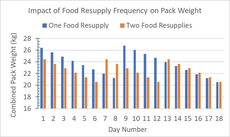
If we’d used two rather than one food resupply we would have:
had 1.6 kg less in our packs for the first 6 days,
heavier packs on days 7 and 8 because we’d take on food earlier. But the top pack weight for these two days would be just under 90% of our carrying capacity, so well within it.
for the subsequent four days (ie days 9 to 12) we’d be carrying around 4 kg less.
thereafter we’d be carrying about the same weight.
With one food resupply we had 6 days when our combined pack weight exceeded 90% of our capacity, with two resupplies none!
So certainly worth considering… ah, the beauty of hindsight!
And don’t feel as though you need to be limited to these two options: Track Angels may help at other locations, such as Sullivan’s Rock.
Dwellingup to Collie

Dookanelly to Possum Springs (22.7 km)
There are many nice options to stop and have a rest along the Murray River during this day. The most beneficial ones are just a short distance before you tackle the notorious Conveyor Belt Hill (SOBO). There are a few spots with one about 500 m before the Harvey-Quindanning Road track crossing. Apparently, the spot has a nice swimming hole that locals use: it would have been perfect on this hot day had we known about it beforehand. The other is about 1.5 km before the road.
The Harvey-Quindanning Road is also an opportunity for a track transfer, with overnight accommodation in a town. This would break the section into a 15 km and an 8 km day, with the steep ascent on the shorter day. Transfer options from Dwellingup or Collie would be worth checking.
On this day we stopped at the road crossing and had an enjoyable lunch with a couple of fellow hikers, before continuing on and tackling the steep climb.
Collie to Balingup

Collie to Yabberup (19.6 km)
The official track distance is 19.6 km. There is a good taxi service at Collie so you could easily split the first day to Yabberup by getting dropped part way and walking back to Collie for the night. Then get the taxi back to the pickup point to start you off the next day. There are two main options: Mungalup Road Bridge which is only 5.9 km from Collie; and the more useful Mungalup Road (south) crossing which is 9.2 km from Collie.

Yabberup to Noggerup (20.2 km)
You could split this 20 km day in two by staying at Glen Mervyn Campsite. This is a car camping spot and popular during school holidays. It’s only 7.5 km from Yabberup so it’s a short day, with 13 km the second day. There is also limited accommodation near Mumballup so that is another option. Mumballup is about two thirds of the way from Yabberup, but before the long climb into Noggerup campsite.
The track runs right past a number of campsites on the western side of Glen Mervyn Dam.

Noggerup to Grimwade (23 km)
There is track access at Lowden-Grimwade Road. You would need to arrange a track transfer to overnight accommodation back in town. It’s remote, so Collie taxi services may not service the area, so the track transfer company in Collie is a better bet. The road crossing is perfectly placed about 12.7 km from Noggerup Campsite.
Balingup to Donnelly River Village

Gregory Brook to Donnelly River Village (22.5 km)
Willow Springs is a nice campsite 9.8 km from Gregory Brook Campsite. There is a toilet, rainwater, and a shelter, although it’s not a Bibbulmun Track shelter. It forms part of a horse trail that commemorates an old stock route. We stayed here and slept in our tent. The steel shelter has sleeping platforms but would be very cold.
Donnelly River Village to Pemberton

Tom Road to Boarding House (24.2 km)
There are a few options for this longer day.
First (which is what we did) is a nice car camping area at Greens Island, with rainwater and toilets. A little registration shelter lets you get out of the rain to cook, but you’ll need your tent for sleeping. We found a nice pitch amongst the casuarinas. Greens Island is about 10 km from Tom Road campsite, which leaves 14 km the next day.
A more luxurious way to split this 24.2 km day is to stay in one of the chalets at/near One Tree Bridge which is 2.2 km south of Greens Island. There are at least two chalets within 500 m of the track and another within 2 km to choose from. One Tree Bridge is also close to Manjimup, a largish town with many accommodation options. It’s only a 15-minute taxi ride but you need to book ahead because phone reception here is dodgy.
About 6.6 km south of One Tree Bridge is a pretty picnic area where people have camped before. We had lunch there, but there's only room for one tent and we doubt that it is an approved site. However, it is lovely for a long lunch before continuing on to Boarding House, which is what we did.

But before you get to Boarding House, about 3.8 km from the the picnic area, there is an old shelter which is 1.5 km short of Boarding House Campsite.
It is a little rustic but it’s a good spot to stop if you need to, or you prefer a quieter setting than the main hut. The only issue with stopping short yet close to Boarding House is that it makes the next day even longer.

Boarding House to Beavis Campsite (21.1 km)
This spot, about 9.5 km from Boarding House, is the Donnelly River crossing at the Lease Road bridge just before a very steep climb SOBO. This is in the catchment area so camping is not permitted. It is fairly remote so it could be difficult (costly) to get a track transfer. Instead, we recommend breaking up the preceding days hiking so you aren’t too fatigued and can tackle this long day in one hit, stopping at this spot for a long restful (early) lunch as the above couple did, before proceeding on to Beavis Campsite.

Beavis to Beedelup (22.0 km)
There is the option here to stop short at Seven Day Road or Beedelup Road (Karri Forest Explorer Drive), which would reduce the day down to 17.8 km. If you book accommodation at Karri Forest Lodge you could most likely arrange a pickup by the lodge or a taxi from Pemberton to take you to the lodge. There is also Beedelup House Cottage, but they have a minimum 2 night stay and may not meet your budget. These accommodation options are within 4 km of Beedelup campsite, but it’s a biggish climb to the campsite and those last few k’s are always the hardest on these long days. Apparently there are excellent meals at Karri Forest Lodge!
Most people just keep going as we did. We had an extra long break at Beedelup Falls which was lovely, which meant the final 1.5 km from the falls to the campsite was a pleasant walk.
If you do stay at the lodge, you have a short 4 km uphill walk to Beedelup Campsite the next day. So the opportunity for a sleep in, brunch at the lodge and a picnic at the waterfalls!

Beedelup to Pemberton (25.1 km)
This is a long 25 km day but is mostly gentle gradient once past the short climb out of Beedelup Campsite. The other steepish section is between Big Brook dam and Pemberton. There is a car camping site at the Arboretum just upstream (before) Big Brook Dam and about 6 km before Pemberton, and before the last climb of this section. It’s close to the track. We had planned to stay here and have a leisurely 6 km stroll into Pemberton for an early lunch the next day, but the weather was appalling (23 mm of rain and blowing a gale!) so we pushed on to Pemberton and a hot shower. We got to Pemberton by 3:30 pm, so had plenty of time.
Pemberton to Northcliffe
We found the section from Pemberton to Schafer Campsite to be one of the most demanding of the track. Not only were we managing Helen’s fickle achilles, but I had made it harder for ourselves by skipping a food drop at Northcliffe. The weather on these days was hot for hiking. I also carried extra water as a contingency in case the achilles spat the dummy and we had to stop, so we would have enough for dinner and a short walk into camp the following morning.

Pemberton to Warren Campsite (22.6 km)
There are a few lovely options here. The first is what we did. On one of our rest days we took a cab to the Gloucester Tree, climbed the tree for a look, and then walked downhill back to town. The day we left Pemberton we got a taxi back to the Gloucester Tree, and then headed to Warren campsite. This reduced that day to Warren Campsite by about 3 km to 19 km.
Another option is to get dropped at Collins Rd (13km out), and hike back to Pemberton, climbing the Gloucester Tree (or not) on the way back into town. The next day, get dropped at Collins Road again, leaving just 10 km to get to Warren Campsite. The transfer would need to be pre-booked (one or two days ahead should be sufficient) because of unreliable phone reception; the taxi service in Pemberton was very good.
The Pemberton tramway runs to the Cascades twice daily, Monday to Saturday (bookings required). Friends on the track used this option and told us it was delightful. If you walk back to Pemberton and then get a transfer to the same spot the next day, (or catch the tram again) you’ll have a unique experience with the remaining distance a relaxed 13.4 km.

There, out of sight on the other side of the lake, where we are not, are hot showers and coffee! Still, the lake was beautiful.
Warren Campsite to Schafer Campsite (22.1 km)
The climbs along this section are relatively steep. There are very few options between Warren and Schafer to camp; the land is sloping and forests thick. There is a road crossing at Wheatley Coast Road North where you might organise a track transfer, but this would need further investigation with local taxi or Uber services (there was no transfer service out of Northcliffe when we hiked). The road crossing is 17.3 km from Warren Campsite so a good distance. But it's just another 4.9 km to Schafer Campsite, so we just kept going at a comfortable pace. Of greater interest to us was the option of a hot shower and bed at Karri Hill Cottages. No saving in distance, just a shower and COFFEE - but, alas, we didn't realise it was on offer until too late!
Northcliffe to Walpole
Lake Maringup to Dog Pool (25.7 km)
Statistically this is the longest day of the hike, but not necessarily the hardest because elevation gains are modest. There are spots to wild camp, but they are illegal and only 10 km or less from Lake Maringup. Plus, you'd need to carry an extra day of water so this isn’t an attractive option. Track access points are at Chesapeake Road (east) which is 9.1 km from Lake Maringup Campsite, and Deeside Coast Road which is 17.1 km from Lake Maringup. Track transfers from Walpole are your best option if you want to split this day, but it is an hour’s drive from Walpole and will be expensive.
When we hiked through here the track had only just been opened after a very wet and stormy winter.
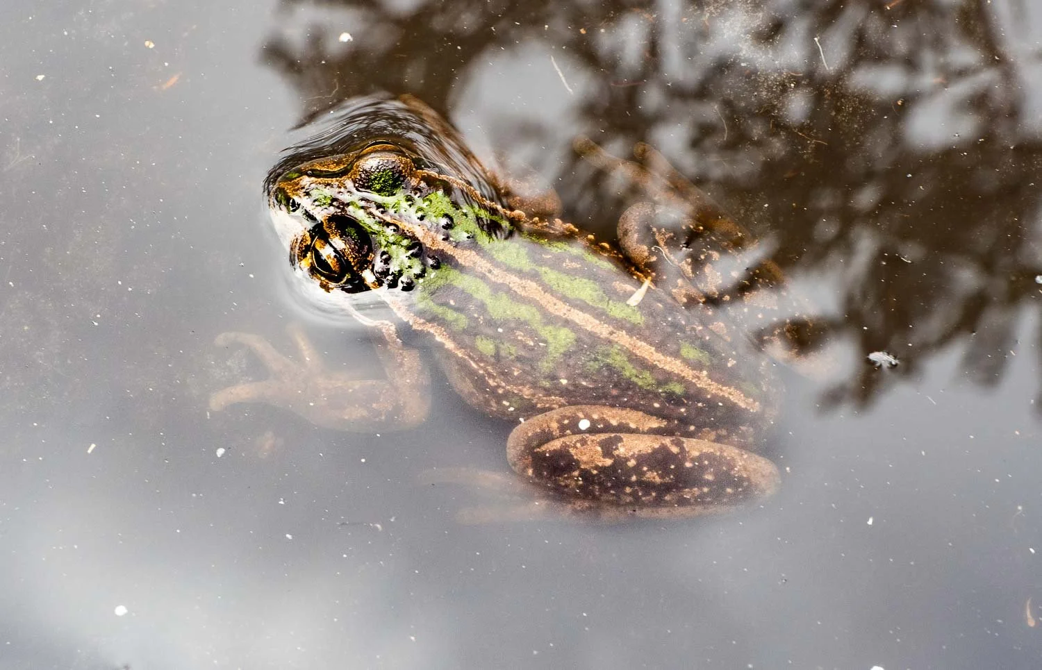
As a result, we waded through numerous long, large pools (38 of them were over boot depth and yes, we counted!). We shared the pools with thousands of tadpoles and the odd frog. And there was also a lot of fallen timber which we had to either climb over, around or under, because track volunteers had not been able to clear all of it yet - it was still too wet. That all contributed to making it tougher than might normally be the case.
Whilst a bit tired we made it into Dog Pool in plenty of time, arriving around 4 pm with a few good rests along the way. It took us about 9 hours.
Walpole to Denmark

Walpole to Frankland Campsite (18.4 km)
We split this day because it was easy to do so by using a track transfer to the South Coast Highway track crossing point on one of our rest days. We then walked back to town via the Bibbulmun Track with a delightful side trip around the Peninsula near Coleman Beach (Knoll Drive) to hunt for orchids. That meant the following day we got dropped back at the Highway crossing and only had a 15 km day to Frankland Campsite.

Peaceful Bay* to Boat Harbour Campsite (23 km)
Many regard this as the most demanding day of the trek so it is worth working through some options. There are no simple ways to split the day, but here are some ideas you may like to consider.
The day can be split by walking from the Caravan Park, along Old Peaceful Bay Road, then to the track cross over point where you join the track for the first time and continue on. That saves about 2 km, but you miss some of the marshy areas just north of Peaceful Bay. You can still explore the marshy areas if you stay an extra day in Peaceful Bay, do a loop day walk through the marshy section, and return via the road route to the Caravan Park.
The days walk into Boat Harbour then becomes 21 km.
One couple had tried to shorten the day and avoid the canoe crossing by walking along the beach and crossing at the inlet. That was a major mistake - the inlet could not be crossed and the scrub was impenetrable, so they had to backtrack a long way to get back onto the Bibbulmun. So whilst this might at first seem like a good option we’d suggest you don’t try it… and in any case, why would you want to miss the fun canoe crossing!
Further along, there is an alternate route through Quarrum Nature Reserve. The alternative route adds an extra 2 km to the main route which goes along the beach. We had, the previous day, spent a lot of time walking along the coast into Peaceful Bay. Suffice to say the weather was not at all peaceful with literally gale force winds; the forecast for our walk out of Peaceful Bay was the same if not worse. So we decided to avoid the 2 km exposed beach section and took the inland (Quarrum Nature Reserve) route. The inland route was in fact delightful, but didn’t save any distance for the day. We had however avoided (for us on this day) a troublesome section of the track, and not increased the total distance by much. There are, however, many scenic places to stop for a leisurely rest during the day in the reserve, so take your time whether you go this route or via the standard beach route.
*Peaceful Bay Caravan Park is occasionally closed over winter. Ring to confirm before planning.

Boat Harbour to William Bay (20.4 km)
This day doesn't look particularly arduous from the statistics except of course that there is a 6 km long section along Mazzoletti Beach (after the Parry Beach camping area) included in the day. A fellow hiker, who had done this section many times, alerted us to the fact that going all the way to Willam Bay from Boat Harbour was in fact a very difficult day, particularly straight after the previous long day out of Peaceful Bay. She suggested we should consider stopping at Parry's Beach campground as a way to split the day. That was some of the best advice we got along the track from a fellow hiker. Parry's Beach campsite (11.5 km from Boat Harbour) was delightful, and it meant that a tough day had been very nicely split into two very enjoyable, leisurely days!

William Bay to Denmark (20.0 km)
The last part of this longer day involves walking from Ocean Beach mostly around the shores of Wilson Inlet through the southern parts of Denmark - about 6 km. Whilst it is a pleasant walk, the day is already demanding with the climb up Mount Hallowell, and a long rocky descent down to Ocean Beach. There are several accommodation options in Ocean Beach very close to the track that are worth considering so you can stop there, and then finish the section the next day, taking your time and enjoying the pleasant walk along the edge of the inlet, with a nice lunch in Denmark centre to look forward to. Track transfer options in Denmark can drop you into Denmark if you want to stay there on the first night. There’s a nice spot to stop and wait for a pickup just past Ocean Beach Road, on the shores of the inlet, at Rainbow Close.
Denmark to Albany

Denmark to West Cape Howe (~20 km)
When we walked the track there were access issues on the section between Denmark and Nullaki Hut. The Nullaki side of the inlet crossing has recently rerouted and formalised due to landholder and environmental concerns but was closed when we hiked. You can walk inland around the inlet too, but much of it is along the highway and also not ideal, although it is an official alternate route. The ideal route is a boat ferry across the inlet to Pelican Point, but that is hit and miss. The preferred route solution is transport around Wilson Inlet (we used a track angel) to a drop off point on the Nullaki Peninsula. If you get dropped off, you can stop at Nullaki Hut or continue on to West Cape Howe, creating a 20 km day. That is what were advised to do. Alternatively, a transfer to the Nullaki Peninsula late afternoon leaves a short walk to Nullaki Hut. You can take supplies from Denmark for the night, and then head off the next morning to West Cape Howe.
You may like to split other days. Road crossing access points are well documented on the Bibbulmun Foundation’s website and are marked on the hard copy maps (another good reason to buy them). So there are plenty more ways to split the remaining longer days should you decide to do so. There are also a few wild camp sites for emergencies (but not in national parks, water catchments or reserves). Often just knowing these options are available is enough to make the day more enjoyable and less stressful.

We can verify that there are excellent track transfer options at:
Dwellingup (there are at least two here)
Collie
Pemberton
Walpole
Their contact details can be found on the Bibbulmun Foundation’s website - look under Local Transport Operator under the relevant track section.
But remember also that each extra “nonstandard day” does create extra complexity in terms of logistics and sometimes cost, so it’s a balancing act.
We found that, whilst we still did many 20 km days, most of them were very manageable, and we never pulled up short, just tired (type 2 fun days!) a few times. We also had a few extra-long days by changing our itinerary and skipping a planned camp site in response to inclement weather. Its always good to remember that plans are just that, and they can and should be changed in light of what you are presented with on any day. Stay flexible: the track is definitely doable at a leisurely pace, and will wait for you!

Remembering…
That we made it by only doing a few of the many tweaks we’ve mentioned in this post!
Ringing the Traditional Completion Bell in Albany Visitor Centre