
GPT Northern Section Planning Tips
We respectfully acknowledge the Djab Wurrung and Jardwardjali people as the traditional custodians of the lands and waters of Gariwerd.

View back to Mt Stapylton on Day 1. The spur trail ascends through the crack in the centre, then sidles up the face on left. Don’t worry, it is less steep and exposed than it looks!
The standard northern section consists of four days walking with three overnight stays in designated camping areas. This section is the easiest of the hike, partly perhaps because you are fresh but also because there are no really long days. Nevertheless there is still plenty of elevation gain and loss, and the climbs are typically steep.
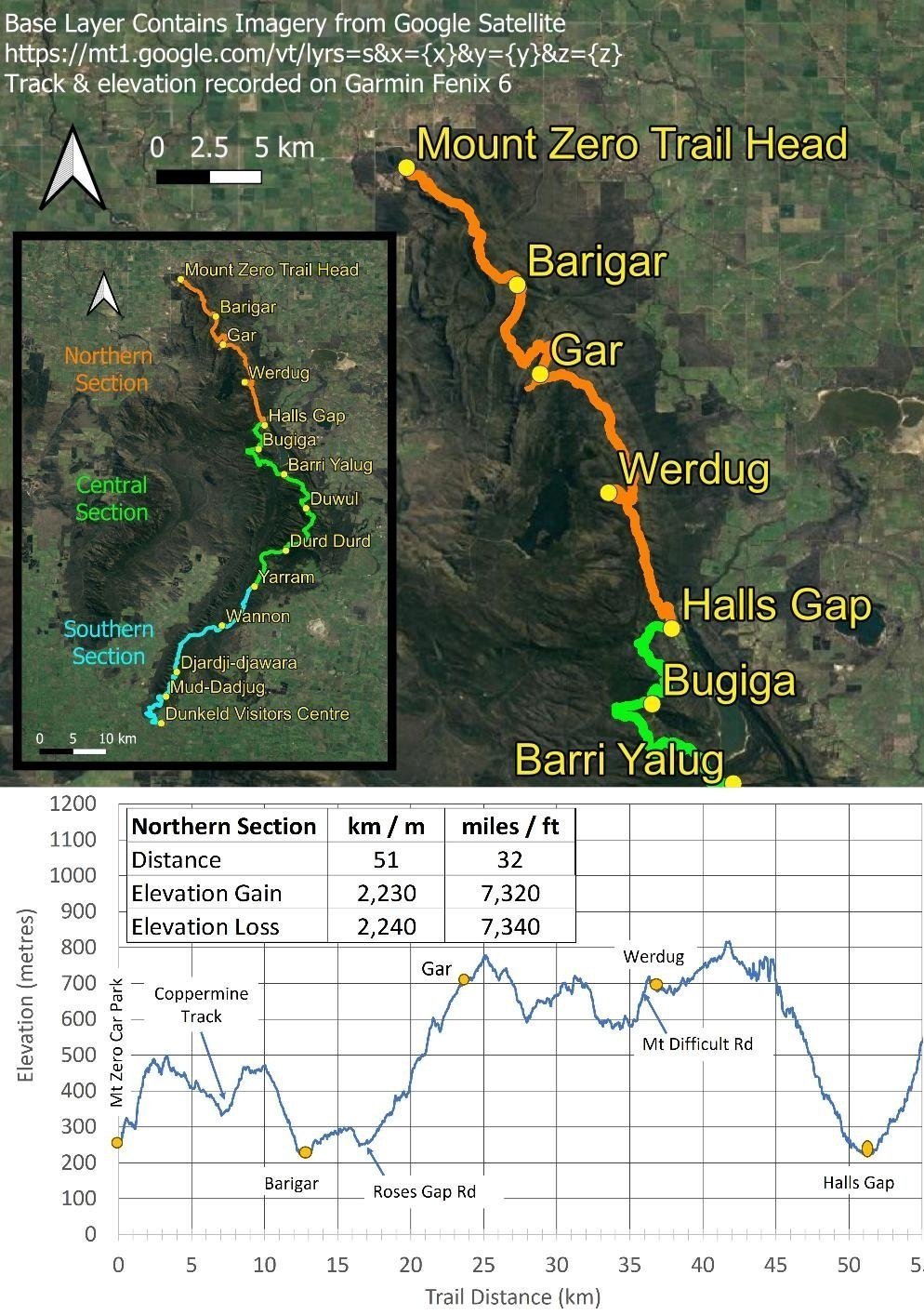
Northern Section Summary Map and Elevation Details
If you plan for walking for most of the day, taking it slow up the climbs and stopping to enjoy the great views, you should be able to complete this section.
Still, you have some simple ways to make it easier, and it’s best to explore these for the section as a whole. Remember, we don’t suggest you should avail yourself of every option on the list: most people for whom this hike is challenging will likely need just one or two tweaks to bring it within their capability.
Whilst our main focus here is to provide guidance on completing an end-to-end hike, there are several ways to complete a portion of this section with a track transfer at the Gar Trail head (approximately 17 km from the trail head at Mt Zero carpark) which is at Roses Gap Road crossing. You can either finish there (a one-night two-day hike) or start there (a two-night three-day hike). Track transfer operator Experience the Grampians may also be able to offer other boutique transfer options.
Subdivide the Section
You could easily do the Northern Section in two parts by utilising the Gar Trail Head at Roses Gap Road crossing for transfers.
You’d start with a transfer to Mt Zero Car Park, overnighting at Barigar, then transferring from Gar Trail Head staying at Halls Gap accommodation (and having a rest day should you prefer to do so) before returning to Gar Trail head with overnights at Gar then Werdug before finishing in Halls Gap. A very nice way to walk this stunning Northern Section in a leisurely way.
Intermediate Camping Options

Coppermine Campsite is one intermediate option.
There are two options for this section:
You can split the first standard day from the Trail Head to Barigar in two by stopping at Coppermine campsite.
This option could be good if you need to start the day late, if you’re hiking with children, if the forecast is very hot, or if you need a bailout option if the weather became unfavourable. Experience the Grampians offers transfers to and from this location. It is along a 500 metre long spur trail from the track. Take the Coppermine Track to the east when you cross it at around the 7 km mark. Coppermine campsite is a public drive-in campsite.And you could split the second standard day in two by staying at Troopers Creek campground which is close to Roses Gap Road. Experience the Grampians and Grampians Peaks Walking Co both provide transfers to Roses Gap Road.
Food Drops / Resupplies
Having food resupplies midway through the section provides the opportunity to minimise your pack weight. There are two locations where this is practical: one at the Roses Gap Road crossing, the other at Mt Difficult Road crossing. Either one saves you the weight equivalent of a day of food. If you use both then you only need to carry one day’s food (plus a spare) at anytime through this section. Yes, it’s possible but expensive. However, we suggest that if you are serious about continuing after Halls Gap, then you should be able to carry sufficient supplies for this Northern section.
Water Management
Growing up in a hot, semi-arid environment, Helen and I are both anal about water on our hikes. We invariably carry more than we need. However, notwithstanding the critical imperative to carry sufficient water, you have some practical and simple ways to manage the amount you carry on many days of this hike by being smart with water resupplies - even if you’re perpetual over-carriers like we are!

Time for a rest and a drink.
There are serviced rainwater tanks at Coppermine Track, Roses Gap Road and Mt Difficult Road crossings. The Mt Difficult Road one is especially helpful because it’s near the end of the day (if travelling north to south) so you don’t need to carry water for the evening meal or following day’s breakfast should the campsite tanks be dry.
For the other two days, both are mid-way through the day so you can top up there to get you through for the rest of the day and/or for the evening meal and following day’s breakfast, depending on the status of rainwater tanks at designated campsites. You also can manage this by hike timing: in winter, early or even mid spring all campsite tanks in this section are large with correspondingly large rooftop catchments so are more likely to have water in them than some of the smaller tanks in Central and Southern sections. However, don’t assume: be sure to check with transfer companies or recent hikers (eg in the Grampians Peak Trail Facebook Group) and monitor seasonal rain before your hike. Be conservative for the first couple of sites until you can gauge the likely water status you expect to find in the future.
Other Ways to Lighten Your Pack
A light pack makes a huge difference, especially for solo hikers and on hikes that are scrambly or with a lot of elevation gain. We’ve already made suggestions for lightening your pack with food drops and water carries, but choosing dehydrated food and other light options makes a huge difference. See our tips on lightweight lunches and why and how to dehydrate meals.
As well, choose your gear with care. See our article on how to lighten your pack: it’s a step by step guide with a range of options for the budget conscious to the cash splashers.
Be Smart with your Side Trips

Spur Trail to Gar: this was highly worthwhile
This section has a number of spur trails to points of interest. You can of course hike every one along your trip, but being more selective makes things easier. A number can be done as day walks from alternative easy access points to the GPT. Here are some suggestions:
-
We did this 2.5 km return walk to the Mt Zero Summit a couple of days before setting off on the GPT. It was highly enjoyable with expansive views from the summit and some special plants along the way. It gives you a little taste of track conditions for the Northern Section of the GPT and you get views towards the early parts of the Trail - it was fun trying to work out where we’d be in a couple of day’s time!
-
The views from here were great and we tied this short 30 minute trip in with a snack break at the top. We would recommend doing this side trip: it’s neither far nor a huge elevation gain.
-
We skipped this one but it is apparently very nice after heavy rain. However, we had had good rains overnight and consequently passed several beautiful waterfalls along the track so we elected to skip the 4 km return walk to Beehive Falls. It’s also worth remembering that these falls can be visited as a short day 3 km return walk from a car park on Roses Gap Road.
-
A 2 kilometre return side track that is said to be fairly easy. We’re told the views are good, but we kept going so we could make the Gar Summit on this day. You can also access the Bluff via the Beehive Falls car park on Roses Gap Road - it’s a 10 km return day walk from there.
-
The standard way of going to Gar Summit is on the day to Werdug from Gar campsite (Day 3). The spur trail is just 300m from Gar hut and before the first steep climb of that day. We arrived at Gar hut early so we could instead go to Gar Summit on Day 2. It was a 2.6km return trip that took us 90 minutes, and allowed us to spend as much time as we wanted at the Summit without being under pressure the next day. A few in the hut took this detour the next morning on their way to Werdug, others simply skipped it - but the views were grand! The day from Gar to Werdug is arguably the hardest of the northern section (particularly if you go to Gar Summit on this day) so it’s worth considering our alternative approach if the weather is good for views.
-
A 300 m long spur trail takes you to the peak. The view is said to be grand. On a clear day you’ll have views along the valley with Halls Gap far below as well as views across the Wonderland Range. If you miss this one due to poor visibility, as we did, you can do it as a 5.6 km 3-hour loop walk from Halls Gap which also takes you past Clematis Falls.
-
There is a short spur trail from the main track on your descent into Halls Gap. It’s a 300 m return detour that is worth the effort if there has been rain recently. When we hiked we were in fog and drizzly rain and with Helen’s unhappy knee we continued on. It would be a very pleasant spot for an afternoon snack in favourable weather. It’s also a popular day walk from Halls Gap.

Chataqua Peak mid left. The sun was trying to break through but cloud was low and, although it was only a 600m detour, recalcitrant body parts were fed up. Don’t stress if you can’t manage or need to skip one side trip for any reason: on this walk, there will always be another grand view until you finish in Dunkeld.
Manage Your Time
Simply put, start early so you can have lots of breaks without time pressure. Walking faster than your natural pace takes more energy and having to hurry in itself is tiring both physically and mentally for many of us more leisurely folk! Don’t underestimate the day, or the impact time pressure can have on your enjoyment of your hike.
Day by Day Tips (these are also in the daily blogs)

Daily blogs have many images of the track so you can get a real sense of the level of difficulty. But remember that inclement weather, be it very hot, cold, wet, windy or in whiteout, makes everything trickier! Stay flexible.
-
One of the easier days on the track but you could split the day in two by staying overnight at Coppermine campsite. It is along a 500 metre long spur trail from the track. Take the Coppermine Track to the east when you cross it at around the 7 km mark. Coppermine campsite is a public drive in campsite.
There is a serviced water tank where the GPT crosses Coppermine Track, so you don’t need to carry water for the whole day.
-
A serviced water tank is located at Roses Gap Road crossing, which is about one third of the way between Barigar and Gar so again, remember you don’t need to carry water for the full day.
This day could also be spilt approximately in half by taking a short 250 metre long spur trail to Troopers Creek campground. The spur trail is approximately 4.5km along the GPT from Barigar camp. Water is available at Roses Gap Road (which is before the spur trail to Troopers Creek) so you would need to fill up there sufficiently to the campground and to Gar the following day.
Roses Gap Road is a potential resupply point for a food drop should you need it.
-
There are no simple ways to shorten this day. Whilst there is a serviced water tank, it is located at the Mt Difficult Road crossing which is very close to Werdug campsite. If you are concerned about the campsite not having water then you should fill up with water at the road crossing so you won’t need to double back.
The Mount Difficult Road crossing is a potential but very expensive resupply location should you need it, unless you do the drop more cheaply yourself ahead of time.
-
There are no practical options to shorten this day – just use the lure of a pub meal, shower and clean sheets to get you to Halls Gap! You’ll need to carry enough water for the full day to get you into town.

Plenty of well-constructed steps in this section…

… and of course it’s not all rock and steps!
Most fit people should have no trouble with the Northern Section: Helen is a very slow hiker of moderate fitness and still managed to complete it… together with hundreds of photographs every day! The track is well constructed with many steps rather than boulders and loose rock as found in the central and southern sections.
We met several other older hiking couples who, like us, were tackling more challenging hikes while we have the ability to do so. Having said that, we know of people in their sixties who have run the entire GPT; a nonogenarian has completed it in four days! Of course, regardless of age, we are slower hikers here!
So these tips are as much to inspire confidence to plan flexibly and tailor to your exact needs: knowing these options are available allows you to tackle a hike with a Plan B. If you think this section is near your challenge limit, plan conservatively and be sure to look at the elevation profiles and pictures of the track in all the daily blogs to better assess whether this section is within your ability to complete with or without modifications.

We may have missed misty Chataqua Peak, but this is the view that greeted us as we dropped below the cloud. Actually, this fantastic hike is pretty much all view. Enjoy whatever bits you do, in whatever way you do them!