
Mt Barker, South Australia
We acknowledge and pay our respects to the Peramangk People and recognise their ongoing connection with the land.

You’ll see beautiful 360 degree rural views on this delightful short loop hike
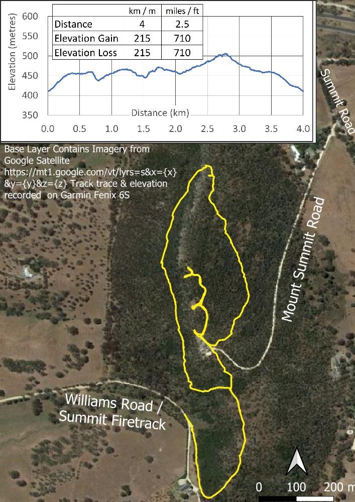
This easy, short day hike circumnavigates and then reaches Mount Barker Summit, a small peak that remains one of the few uncleared areas of native vegetation in the region. You can hike to the top from Williams Rd and then complete the loop as we did, making for a 4 kilometre hike with 215 metre elevation gain, or you can drive via Mount Summit Road to the carpark at the top and complete just the loop at 2.5 kilometre and 110 metre elevation gain. The latter would be an ideal hike with young children, say 4+, finishing with a picnic at the tables near the summit. (Note that there are no toilets at the summit - the nearest being 3 km away in the small village of Nairne).
The Mt Barker quartzite is one of the southermost occurrences of the ABC Range quartzite seen on the peaks of the Flinders Ranges, and the shallow, rocky soils influence the vegetation. On the hot, dry western side, you’ll find woodlands of silver banksia (B. marginata), rough-barked manna gums (E. viminalis) and sheoaks (Allocasuarina verticillata) with an understorey of acacia, hop bush (Dodonea viscosa) and correa. On the southern and eastern sides, you’ll see a dense groundcover of grasses and lillies.
We have done this hike many times because it is rich in orchids, particularly in spring. My list includes Diuris (several species including D. sulphurea), Caladenia carnea, C. tentaculata and C. latifolia, these last ones in large numbers, Thelymitra rubra (also large numbers, especially on the southern spur track), T. grandiflora and more. On the easterly aspects, you’ll find Microtis and Pterostylis species. In winter, also primarily on the southern side, often in deep shade, you’ll find Corybas, Acianthus and Cyrtostylis.

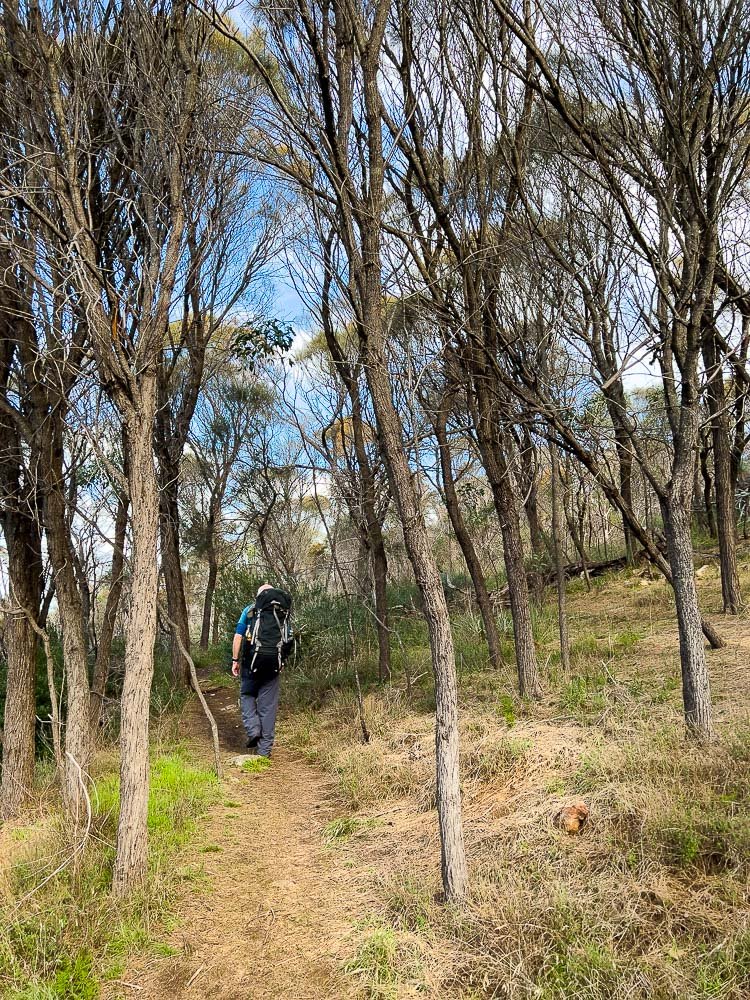
The long route starts from the end of Williams Rd. With limited parking, you may need to leave your car a little way back. Go through a gate, then up a grassy fire track between dense Acacia paradoxa.

As you climb the spine, the track levels off and, amongst the trees in spring, you’ll begin seeing orchids and other wildflowers.

Caladenia latifolia

Fantastic boulders are scattered along the top of the spine on either side of the track. Gazing beyond them, you’ll have views to the east and west.

You’ll reach the beginning of the loop: head left/west onto single track, with more views through the trees, before the track swings north.

In spring, the understorey here is rich in orchids (T. rubra) and lillies.

Rock correa (C. glabra)

Diuris sulphurea

After following the contouring track beneath the Casuarinas, you’ll near the northernmost elevation and the vegetation and views open up.

On the way you may see Thelymitra grandiflora …
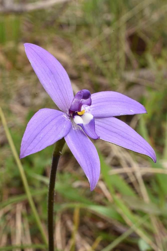
… and Purple Cockatoo (Glossodia major)

A pause on a sunny rock to soak in the views northwest; the township of Mt Barker is out of sight to the left.

Continue around and you’ll begin heading south again.

Drosera whittakeri in damp spots amongst the exposed rock slabs
The track continues to contour beautifully around the peak. Here, casuarinas on the eastern side with an understorey of lillies, grasses and forbs.

Pink Fingers (Caladenia carnea)

Onion orchid (Microtis uniflora)

When you reach the carpark, turn right towards the summit proper. Nearby, you’ll see interpretive signs.

The main path to the lookout at the summit is well graded and smooth, easy walking.

Picnic tables with lovely views westwards to Mt Lofty and over Mt Barker township.

Graded steps as the path nears the top.

And, right near the top, you’ll find a sundial and, of course, the trig point.

Mt Barker summit Trig Point.

Return to the car park and, if you’ve hiked up the spine from Williams Rd, find the continuation of the loop near a boulder at the entrance of the carpark. Follow this track back down to the spur and retrace your steps down the firetrack to Williams Rd.

Mt Barker is not high above the surrounding landscape, but it’s high enough for lovely views in every direction, and this delightful short walk takes in all of them. Highly recommended.