
Day 13: Nerang to Gringer Creek
We acknowledge the Nyoongar People as the traditional custodians of the land and waters along the Bibbulmun Track

Today is an almost flat hike, but we plan to get to the hut and then complete a short out and return to the Servo on the highway nearby to charge camera batteries, which are almost completely depleted. This makes the total distance for the day 19.3km and adds time pressure, something I loathe and must learn to handle better. After all, it’s my choice: charging batteries hasn’t been imposed like an Act of God!
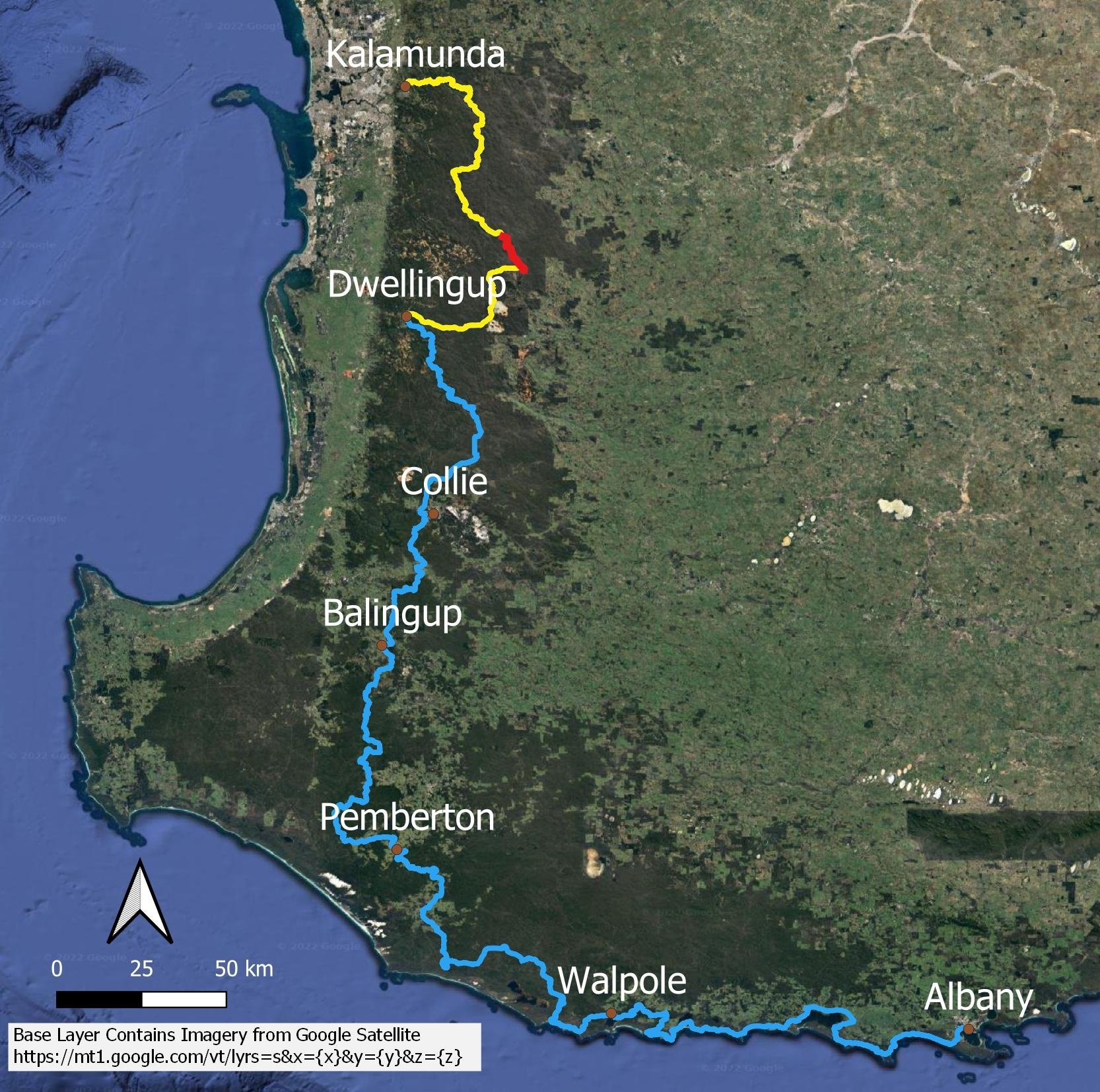
Here’s where we are today…
still inching our way south!
As soon as there’s a goal that we need to reach, it’s much more difficult for me to enjoy the journey because, as you will have gathered by now, it is the wildlife, plants, flowers and views that provide meaning, and having to rush past them makes the hike significantly less enjoyable. Conversely, Geoff is happy walking at whatever speed because it is a meditation; his immersion in landscape happens regardless, and he’s able to separate destination from journey far better than can I.

The day’s main hike details - the trip to the servo is a flat 1.4 km each way which is not included in the above figures. Use Bibbulmun Track Foundation Map 1 Darling Range.

The morning dawns bright and misty with beautiful light.


Three of a group of seven wonderfully independent and interesting women with whom we shared camp last night. They were just doing an overnighter and had carried in all kinds of delicious things, including bottles of wine and salads and snacks, the envy of us thru-hikers!
Up until yesterday, few people have been sharing the hut, but last night was relatively busy: the group of seven, plus us and our young friends, a few blokes hiking northbound, and a few men hiking southbound. A crowded hut doesn’t affect us as we generally sleep in our tent, but leisurely hikers should be aware that, if you’re late getting to the hut in a normal spring hiking season, there may not be room for you.
This isn’t a problem at all if you carry a tent: most huts have plenty of campsites and you can always pitch on a non-designated spot on the service track or beside the building. Despite all Bibbulmun track information to the contrary, some people suggest it’s not necessary to carry a tent, not least because hikers are a generous bunch who will squish up and reorganise if you arrive late without a tent, or if it’s raining. But do you really want to be the selfish arsehole who does this to others? Not just once, but multiple times because you’re too slack to carry a tent?
I read in one log book that a hiker nicely settled in a packed hut moved out and set up their own tent in the rain for an inconsiderate woman who arrived late without a tent and whinged loudly to everyone. She could have put her mat on the mulch beside the sleeping platform but no. Trail etiquette exists for a reason: to make the trail as enjoyable for as many people as possible, not just the selfish few. Be a decent human being and the hiking community will embrace you!

Oh, how I love flat woodland country, the understorey sprinkled with a smorgasbord of interesting shrubs and flowers!

Various forms of the white spider orchid (Caladenia longicaudata) are widespread throughout the SW of Western Australia and we see lots today. Unlike many of the tiny, dull-coloured orchid species, these are hard to miss as they stand a good 40-50cm tall, and the flowers are huge. You’re almost certain to see them if you walk the Bibbulmun in spring.

The path wends through healthy xanthorrhoeas and under jarrah. It’s the perfect walking temperature, with scattered clouds and dappled shade under the trees.

One of the few gentle inclines of the day… this one through regenerating woodland after a fire a seas or two ago.

Hibbertia lasiopus

The trees are gradually getting bigger. In colonial times, sailors and pioneers used the size of trees as an indication of water availability, and would come ashore to replenish. If these huge specimens are anything to go by, there is plenty of groundwater here!


A forest clearing. I spot a splash of colour next to the Acacia by the granite…

It’s a herd of donkey orchids (Diuris porrifolia)! No, that’s not official terminology, just a bit of fun we had making up collective nouns for different orchids (A Swat of Midges, A Slime of Snails, a Thwack of Hammers…)

From a distance, this lone flower resembles a scrap of plastic rubbish: Leschenaultia formosa. If you see a flower that’s a ridiculously artificial colour, it’s almost certainly a Leschenaultia!

Bracket fungus

We reach the hut in record time and set up quickly. The campsites have been uniformly excellent thus far, except perhaps last week at Ball Creek, which looked prone to flooding.
After setting up camp, we head to the service station 1.4km away to charge batteries, carrying some of one of our hut companion’s unwanted items. This companion has foot problems, and a sister will meet us at the servo to take these unwanted items to reduce the pack weight. We of course have plenty of time… more than we need.
At one time, this servo provided basic accommodation, hot showers and pub style meals, but sadly this is no longer the case, through no fault of the franchisee. He is accustomed to hikers coming in and devouring everything in the pie warmer, and he has a small table in the corner next to the power point where we are welcome to park our butts for a few hours.
We carry a powerbank but the Olympus camera I use needs a special output, which is somewhat infuriating. Instead, I carry four extra batteries, which are heavy. Again, by now you’ve realised that photography is an important part of my enjoyment, just as a birdwatcher wouldn’t go without a hefty pair of binoculars.
I’ve felt rushed and unsettled for most of the day but now we are here and it’s time to eat. Yay! I manage a pie, a bag of chips and a salted caramel ice cream as well as several cups of tea while we wait (Geoff does pretty well too!); we have a nice conversation with the franchisee. The great thing about thru-hiking is that you can eat anything you want and still lose weight, if that’s one of your aims. Regardless, you’ll get fitter without doing anything other than walking each day, even when your distances are relatively short.

When we get back it’s time for a second dinner. I’m quite tired but it’s as much about the mental rush as it is about the physical. Hopefully I’ll feel better tomorrow.