
Kangaroo Island Wilderness Trail: Planning and Tips
Caves, spectacular landforms, lagoons, cascades, wildlife and wildflowers, deserted beaches, coastal cliffs and wild seas: the KIWT has it all!

The Remarkable Rocks formation is just one of many stunning geological features on this trail.
The Kangaroo Island Wilderness Trail is a spectacular 66km/41mi 5 day, 4-night trail in the southwest of South Australia’s Kangaroo Island. If you’re an overseas reader looking at the Australian map, near the squiggly centre of the mainland’s southern coastline is where you’ll be:
Kangaroo Island Location Map
Hike locality map
It’s an absolute cracker of a hike with amazing landscapes and teeming wildlife, so read on for everything you need for planning your own Leisurely Walk.
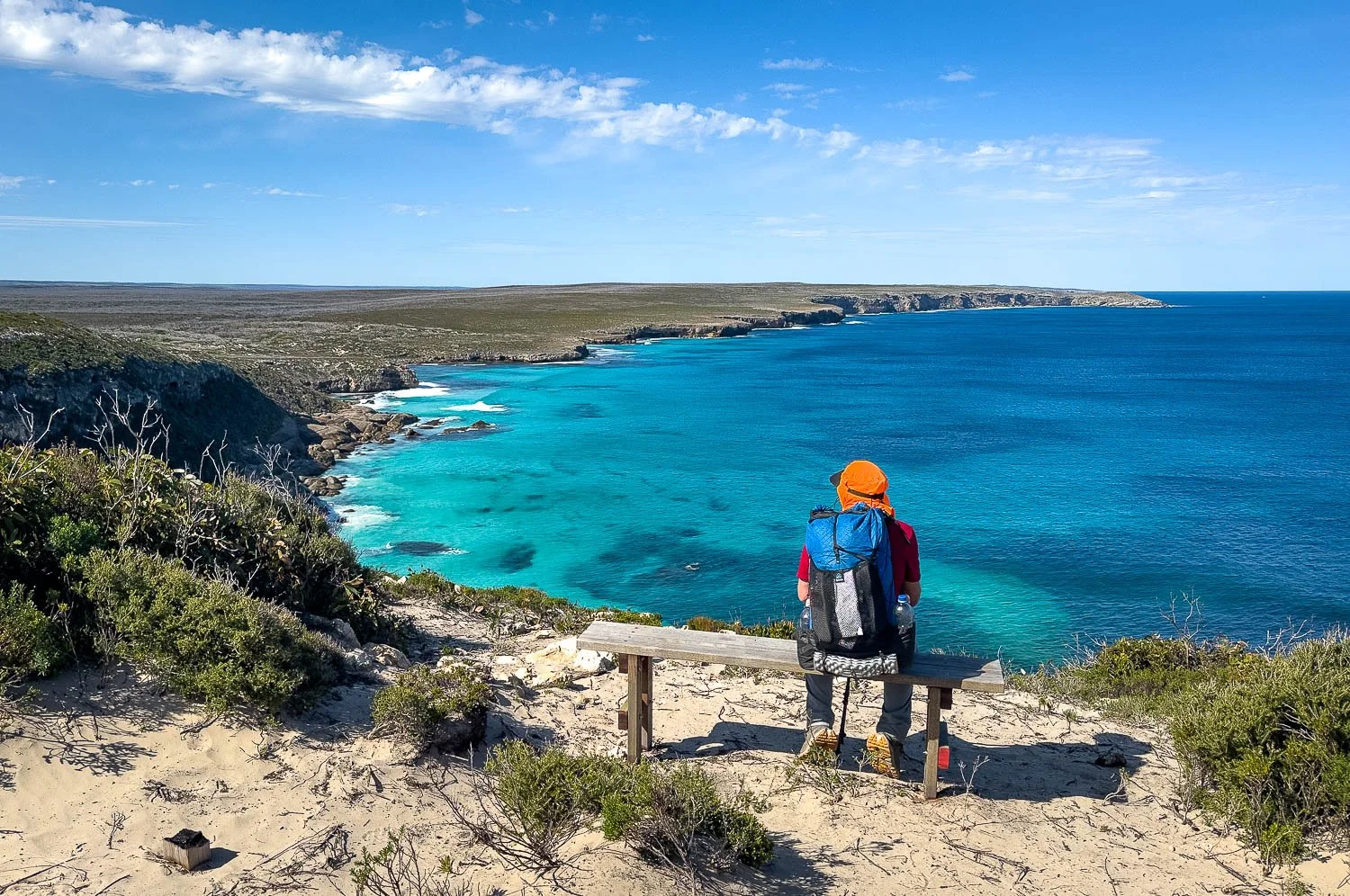
Track Overview
Track Overview:
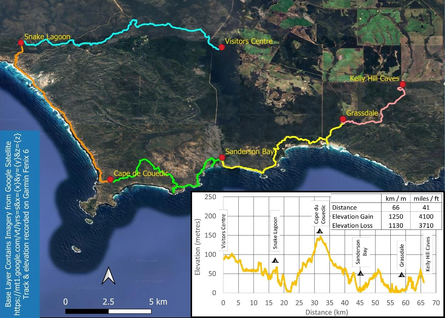
Without side trips it’s approximately 66km/41mi or, with our suggested side trips (Rocky River Beach Outlet, Remarkable Rocks, Sanderson Bay and Hanson Bay), 72km/45mi. We recommend seeing Admiral’s Arch near the tip of Cape de Couedic before or after your hike.
And the elevation profile - 1,250m (4,100ft) elevation gain is as close to flat as you can get. The side trips we’ve recommended have minimal elevation gain/loss associated with them.
Hiking in the driest state on the driest island continent, you’d expect little water, but the KIWT is incredibly varied. Your walk starts inland at the Visitor Centre before meandering past a lagoon, pools and cascades along Rocky River towards the coast and your first campsite.

The ironically named Unnamed Lagoon.
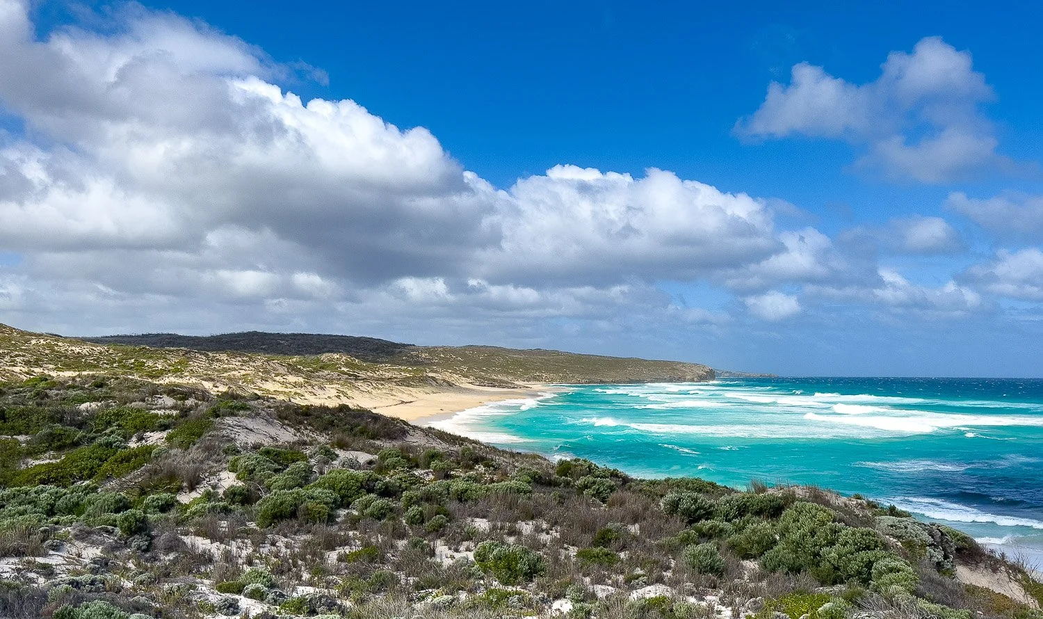
On the following days, traverse rocky limestone cliffs and sandy beaches with crashing waves:
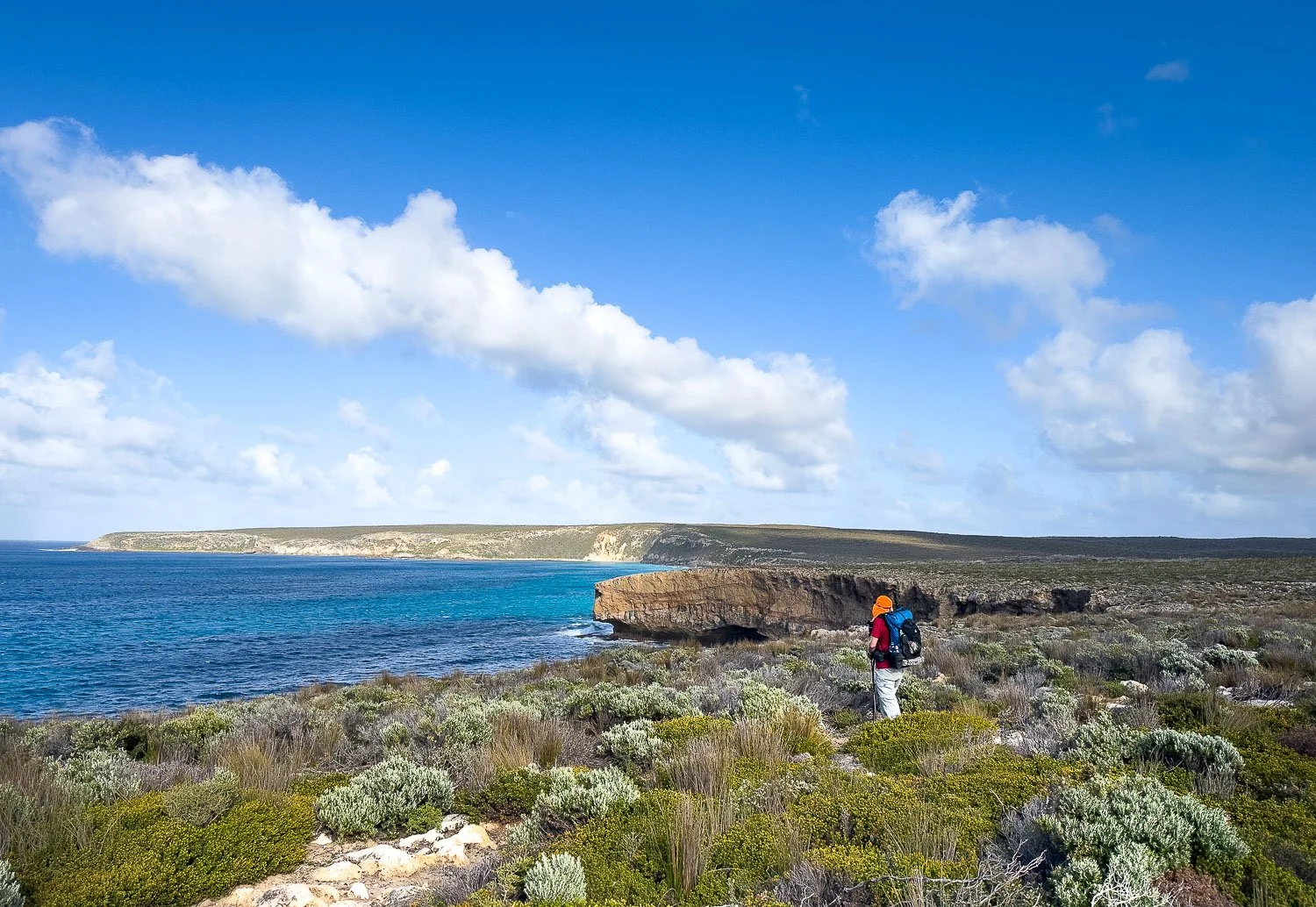
Spectacular coastline, benign here…

…wild and exposed in different weather.
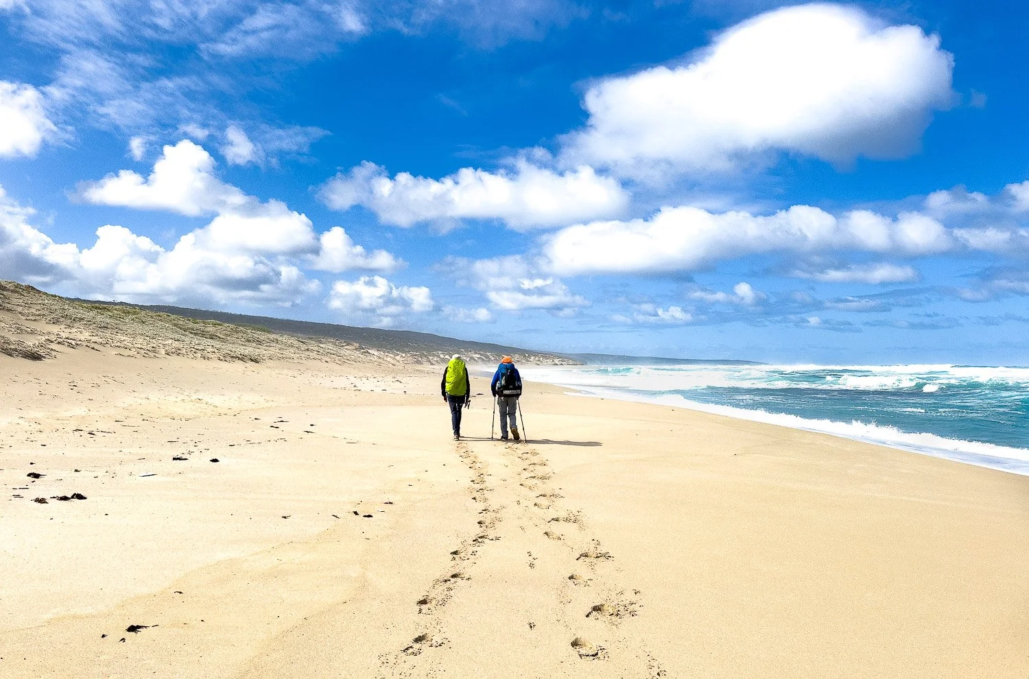
Maupertuis Beach
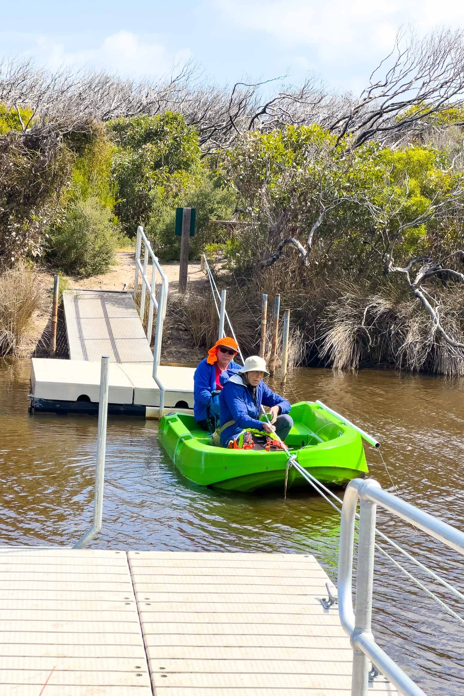
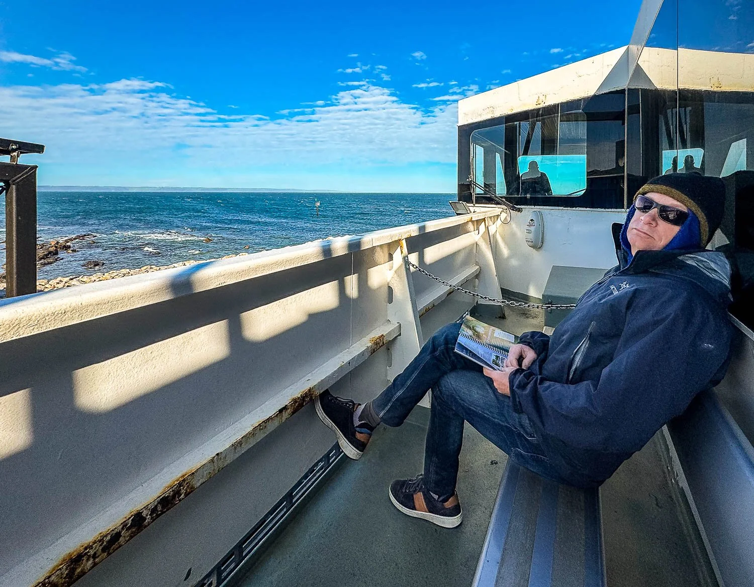
There’s even a fun little ferry crossing on Day 4!
You pass breathtaking rock formations like Admiral’s Arch with its seal colony (which we recommend you explore as a separate day walk), and Remarkable Rocks; the last part of the trail heads inland again, passing more lagoons before ending at Kelly Hill Caves; the tour is included in your booking fee:


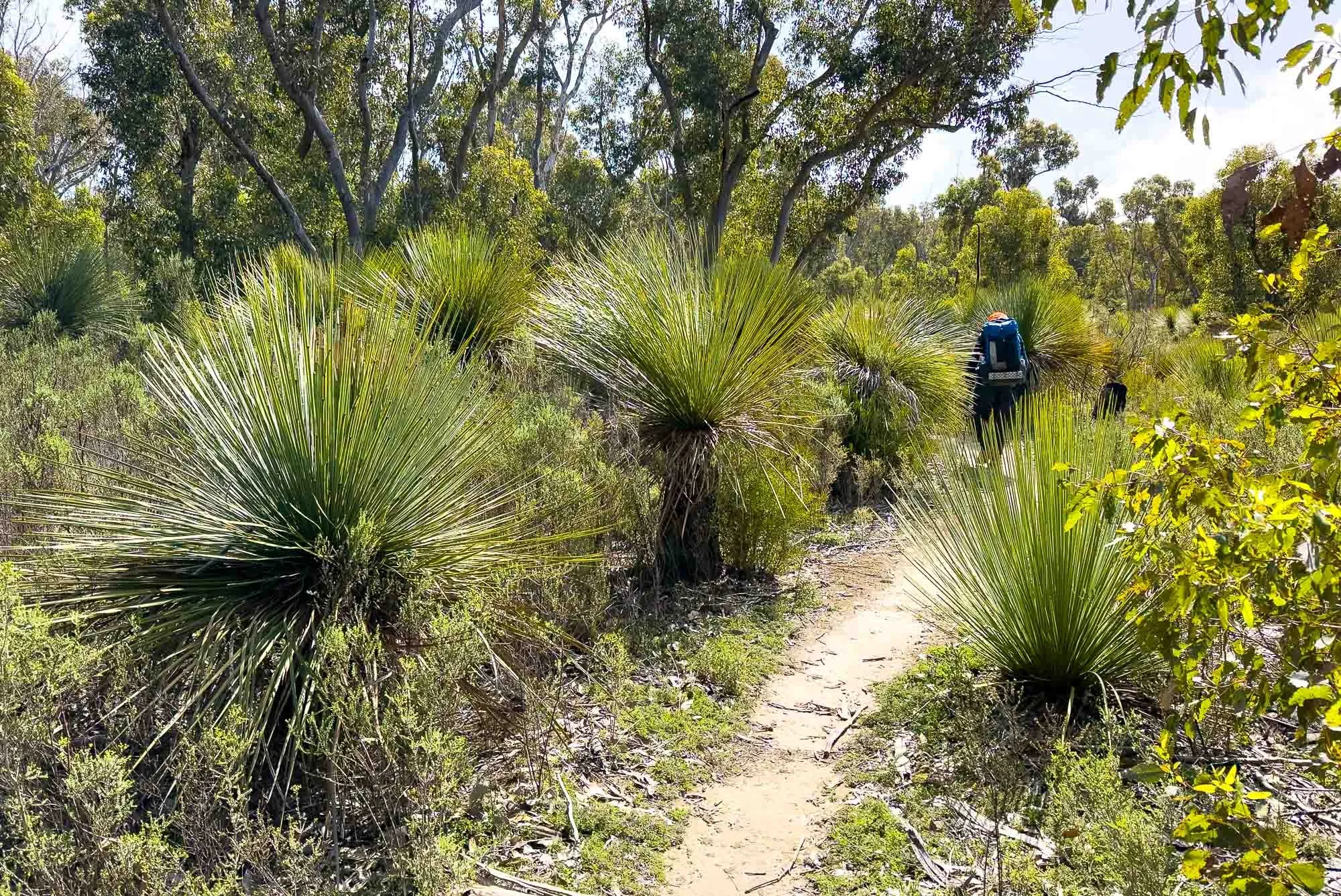
The wildlife is nothing less than extraordinary. Kangaroo Island is different to mainland Oz in that it’s without foxes or rabbits, with feral pigs now also controlled, creating a unique ecosystem. After the 2019 bushfires, the vegetation has recovered and nature lovers will relish the diversity.
You’ll see seals and sea lions (and their pups in spring), and many hikers also spot whales and dolphins. Goannas are common spring-autumn, the woodlands and mallee teem with birds, while along the dunes you’ll pass rare hooded plovers and pied oyster-catchers. Koalas (and platypus) were introduced to the island, and of course there are endemic echidnas, kangaroos and wallabies. Wildflowers peak late winter and spring, with brilliant heath and rare orchids. It is fantastic, and we suspect that overseas visitors are likely to see more wild native animals in a week on Kangaroo Island than they would almost anywhere else in Australia!


Is the Track for Slower Hikers?
The answer is [a qualified] YES! You should have one or two overnight hikes under your belt and be moderately fit, but distances are reasonable, especially with our recommended itinerary. And there is little elevation gain and loss, so you comfortably reach camp each day.
Although the first day is by far the longest distance at 18km/11.2mi, the track is flat, smooth, firm sand almost the entire way — you’re likely to make good time:
Primarily smooth with some gravelly substrates on days 1 and 5.
Although we often suggest splitting longer days to make them easier, we don’t recommend doing this on your first day. If you think you need to spend your first night at intermediate Rocky River campground 8.2km/5.1mi along the trail from the Visitor Centre, the following days are likely to be too demanding despite shorter distances because the trail there is so rocky.
The only spot on the KIWT that is steep and rocky is on the spur trail to the Rocky River mouth on Day 2 of the KIWT:
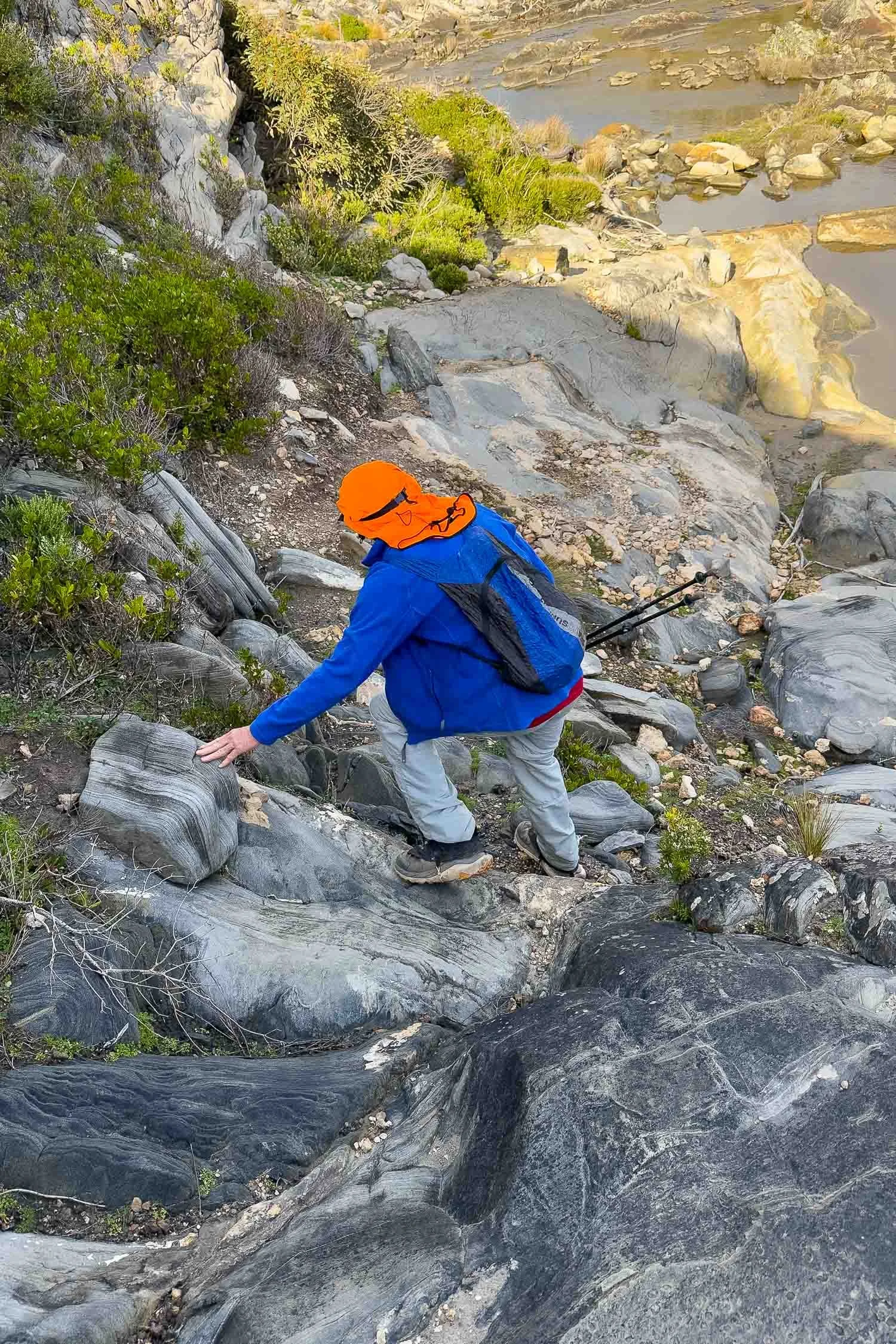
Descending to the mouth of Rocky River doesn’t even really qualify as scrambling.
These two images comprise the trickiest section of the entire trail, so not particularly difficult. And because it’s a spur trail, you can skip it if you wish.
There is a similar relative lack of elevation gain and loss and shorter distances on Days 2-4 inclusive:
Day 2: 14.8km, 310m/gain (9.2mi,1020ft gain)
Day 3: 16km, 165m gain (9.9mi, 540ft gain) if you follow our itinerary and hike Admiral’s Arch and Weir Cove on a different day, but include the Remarkable Rocks (1.8km/1.1mi) and Sanderson Bay (1.2km/0.75mi) side trips in this day.
Day 4: 13.5km, 260m gain, (8.4mi, 850ft gain).
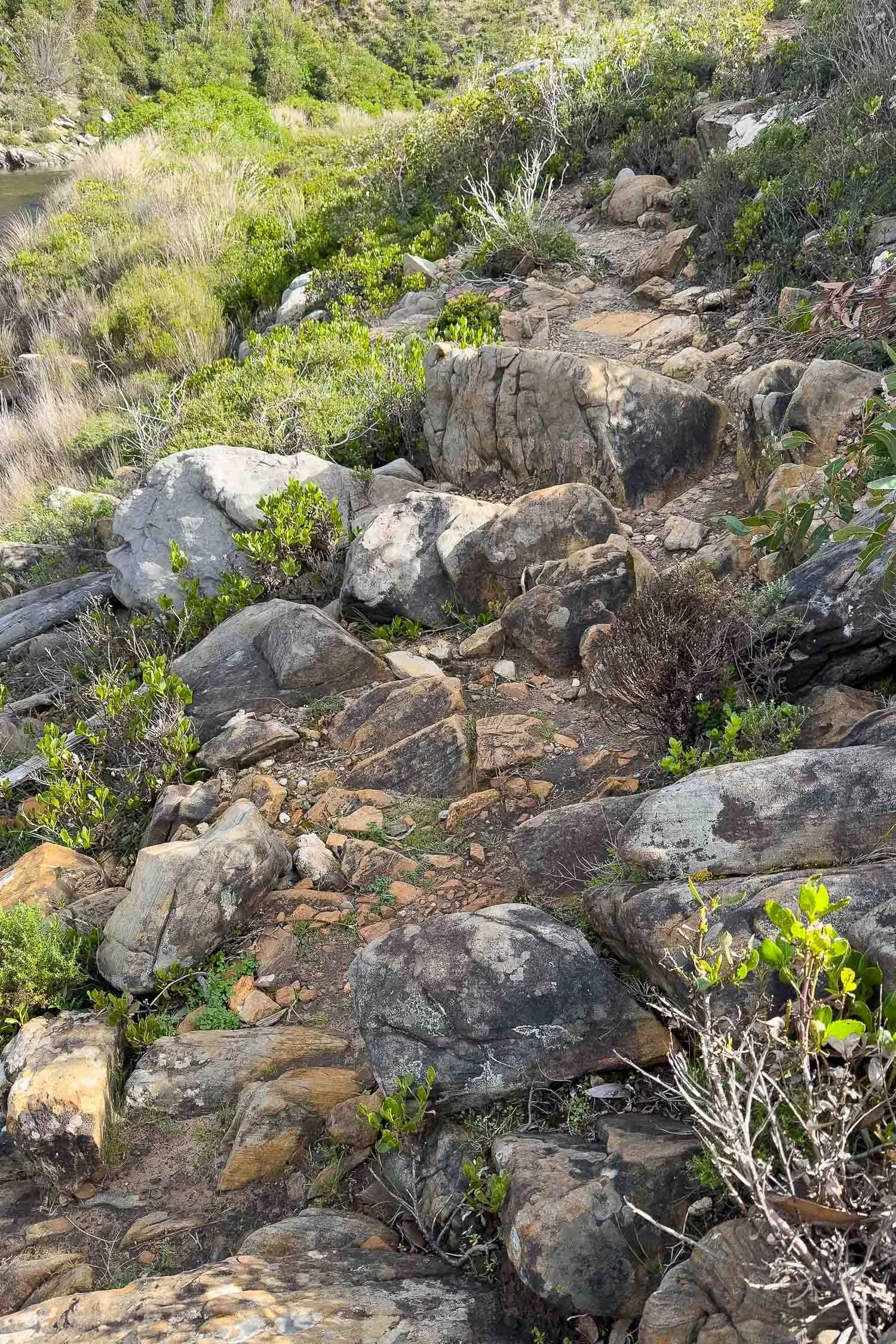
Despite this, the limestone cliffs are extremely rocky and uneven underfoot and, because it is over so many kilometres, not just in spots, the substrate is surprisingly demanding:


Take a look at all the daily blogs (coming soon) for a clear idea of each day: these surfaces deserve their Grade 4 rating because they comprise so much of the trail. Of course, shorter sections on these two days — usually when the track ducks inland, or on lower dunes — have smoother and more sandy substrates, but these are the exception:


Maupertuis Beach can be very soft, as can the dunes behind, but this is only 1.4 km/0.9mi and is a welcome change from the rocks!
Rather surprisingly, we found the substrate tougher than most days on the Larapinta because there the surface alternates, with smooth trail on the flats and the rocky sections restricted to slopes and ridges. Having said that, we took an octogenarian friend who managed the KIWT just fine and loved the hike. She walks daily so is relatively fit with strong legs and feet, but trekking poles and footwear with a firm rock plate were invaluable. And, of course, marvellous views and fascinating vegetation provide plenty of distraction:
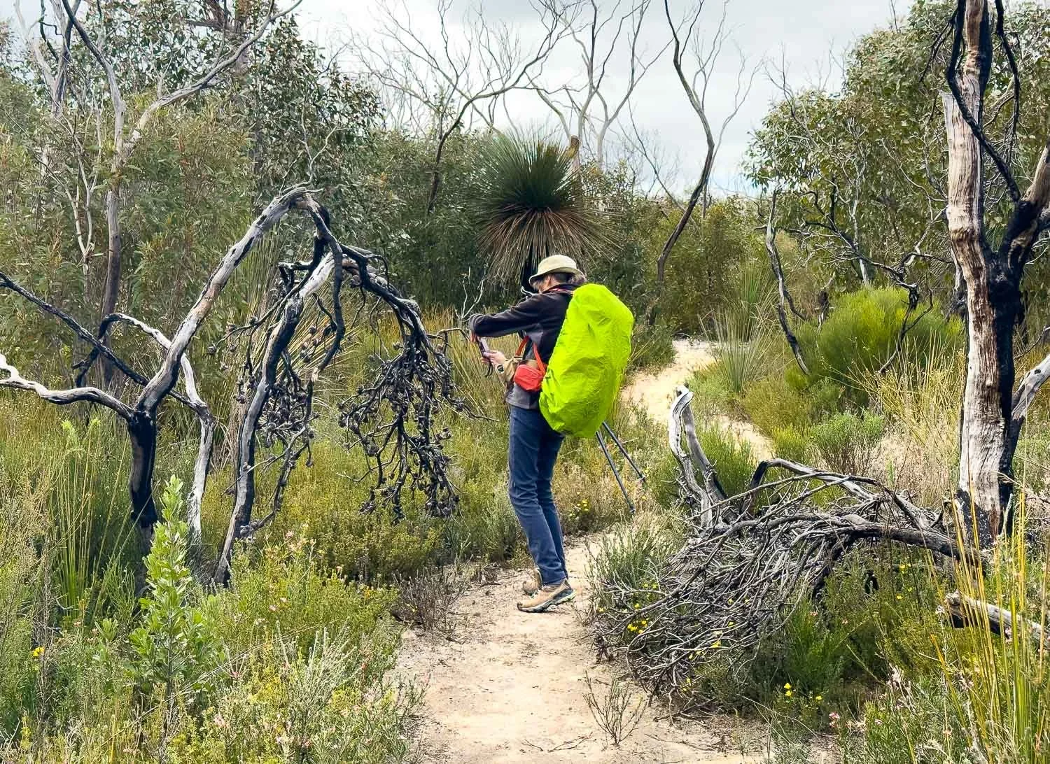
Our friend had no trouble completing the trail with our itinerary. NB: the pants are synthetic, not jeans!
If you include Admiral’s Arch and Weir Cove on Day 3, hike distances and times for slow folk increase from 16km/9.9mi to 25km/15.6miles; official figures cite an additional 9km/5.6mi, 4 hour return hike to Admirals Arch. However, our recommended itinerary means you explore Admiral’s Arch and Weir Cove either before your official hike or, preferably, on the afternoon of Day 5 on trail after you’ve picked up your vehicle. Our recommended 16km/9.9mi on Day 3 includes shorter side trips to Remarkable Rocks (1.8km/1.1mi) and Sanderson Bay (1.2km/0.75mi).
Day 5 — really a half day — is just 7.5km/4.7mi over easy terrain; your biggest climb is to the entrance of Kelly Hill Caves from the car park! If you think you can’t make the 10:30am tour in time, our itinerary has options to see Kelly Hill Caves before your hike or, preferably, after you pick up your car.
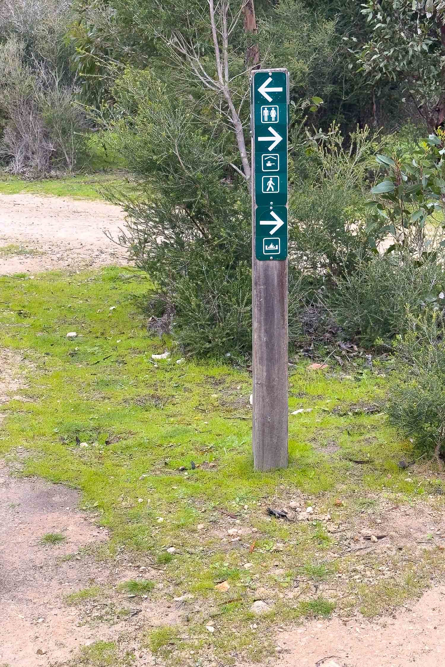
Navigation
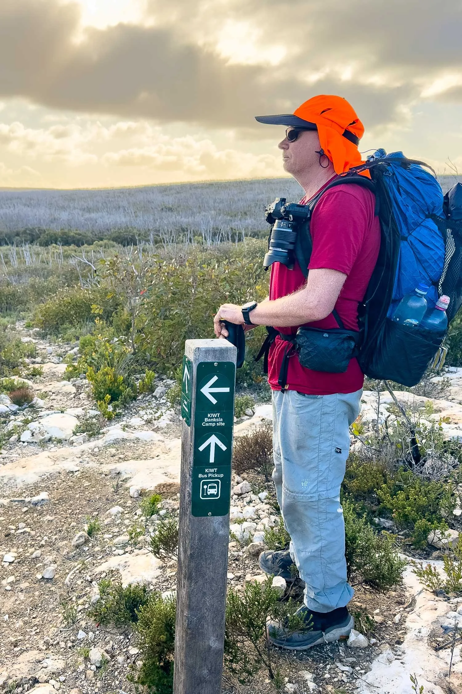
The waterproof paper map and the booklet, included in the booking fee, and signage are excellent, with the only tricky navigation on some of the headlands too rocky and bare for a trail to show — look instead for posts — and the last part of the trail near Grassdale where it overlaps the Hanson Bay hike, with distance markers confusingly reversed at time of writing. Watch for the trail marker on the dune when exiting Maupertuis Beach.
There’s no cellular reception on most of the KIWT so download the trail to your phone mapping app eg Avenza. Alltrails describes the pre-bushfire route starting from the original visitor centre destroyed by fire, thereby omitting much of the current Day 1. Visit Data SA Recreation Trails page to download GPX, ESRI, KML or KMZ files. The place you’re most likely to take a wrong turn is in the campgrounds with their tangle of footpads to hut, campsites, trail, and toilets!


Campgrounds and Facilities
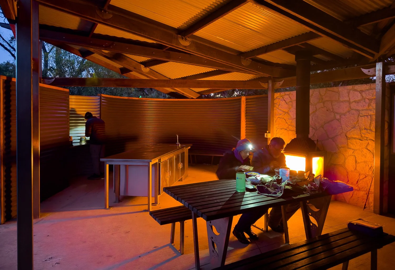
Facilities are outstanding. The original huts were poorly designed and allowed rain to blow inside, but happily have been modified to enclose front and sides:

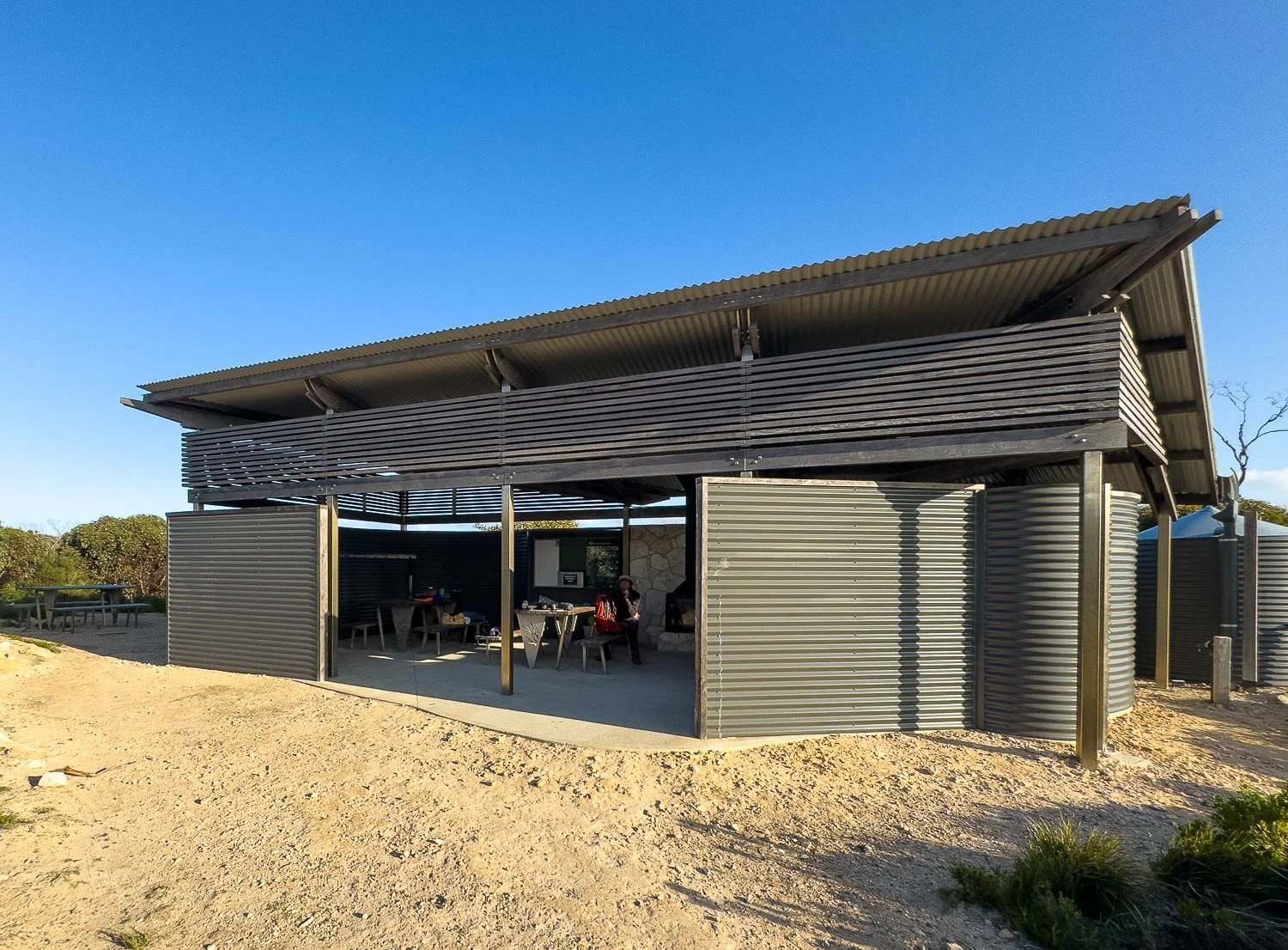
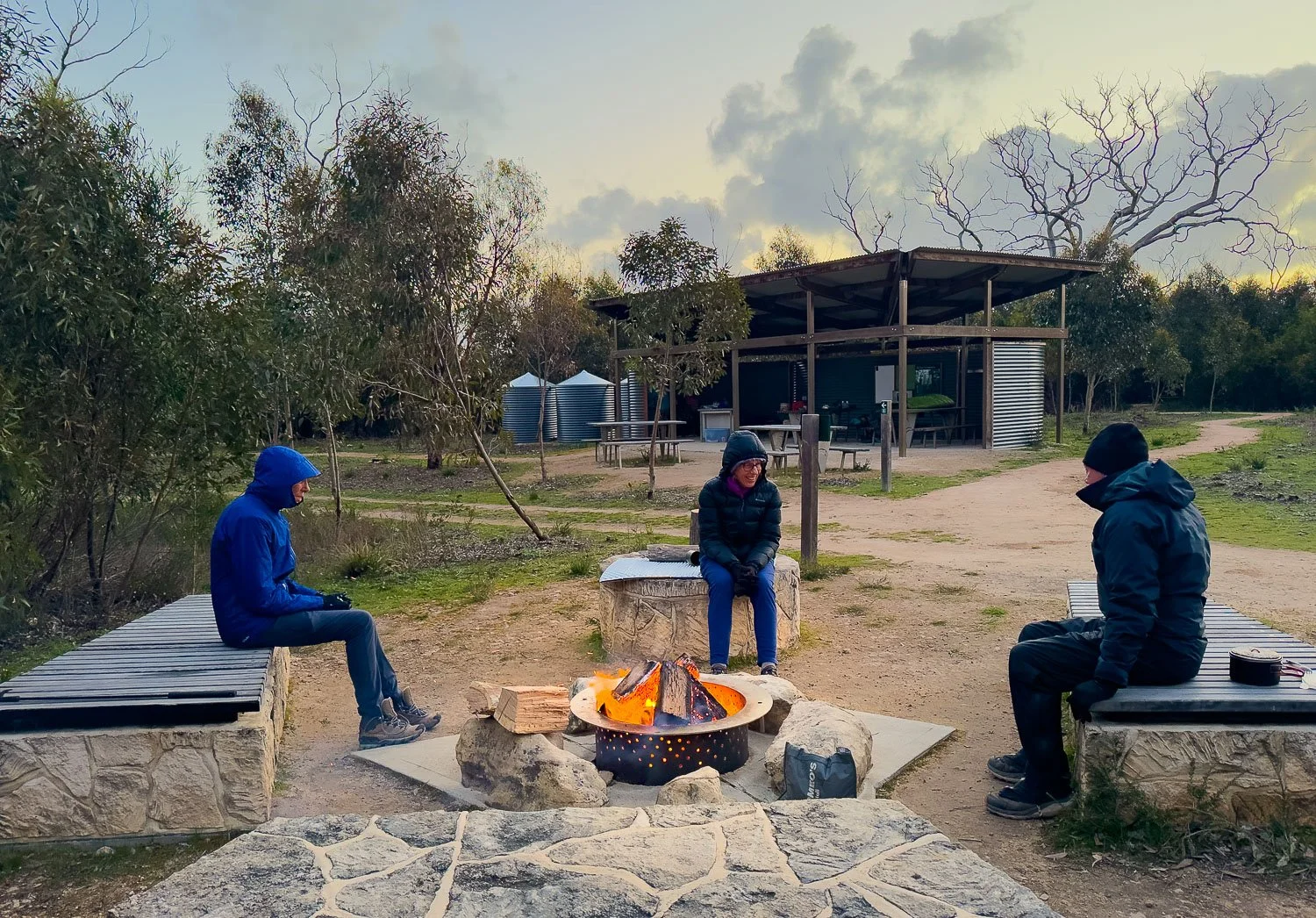
This hike is also excellent for those who prefer a few creature comforts, or to introduce a less experienced partner or friend to multiday hiking. Huts provide reliable water and shelter for cooking each night plus — wonderfully! — a slow combustion heater (April-early October depending on fire season), with a wheelbarrow, firelighters and a well-stocked woodshed. The stainless steel bench has a sink and two two taps, only one marked non-potable though Parks recommend you treat all water; use the under-bench animal-proof cupboards to store food bags. Outdoor picnic tables are great in mild weather. And although toilets are long drop, they have sinks and taps: luxxxuuury!


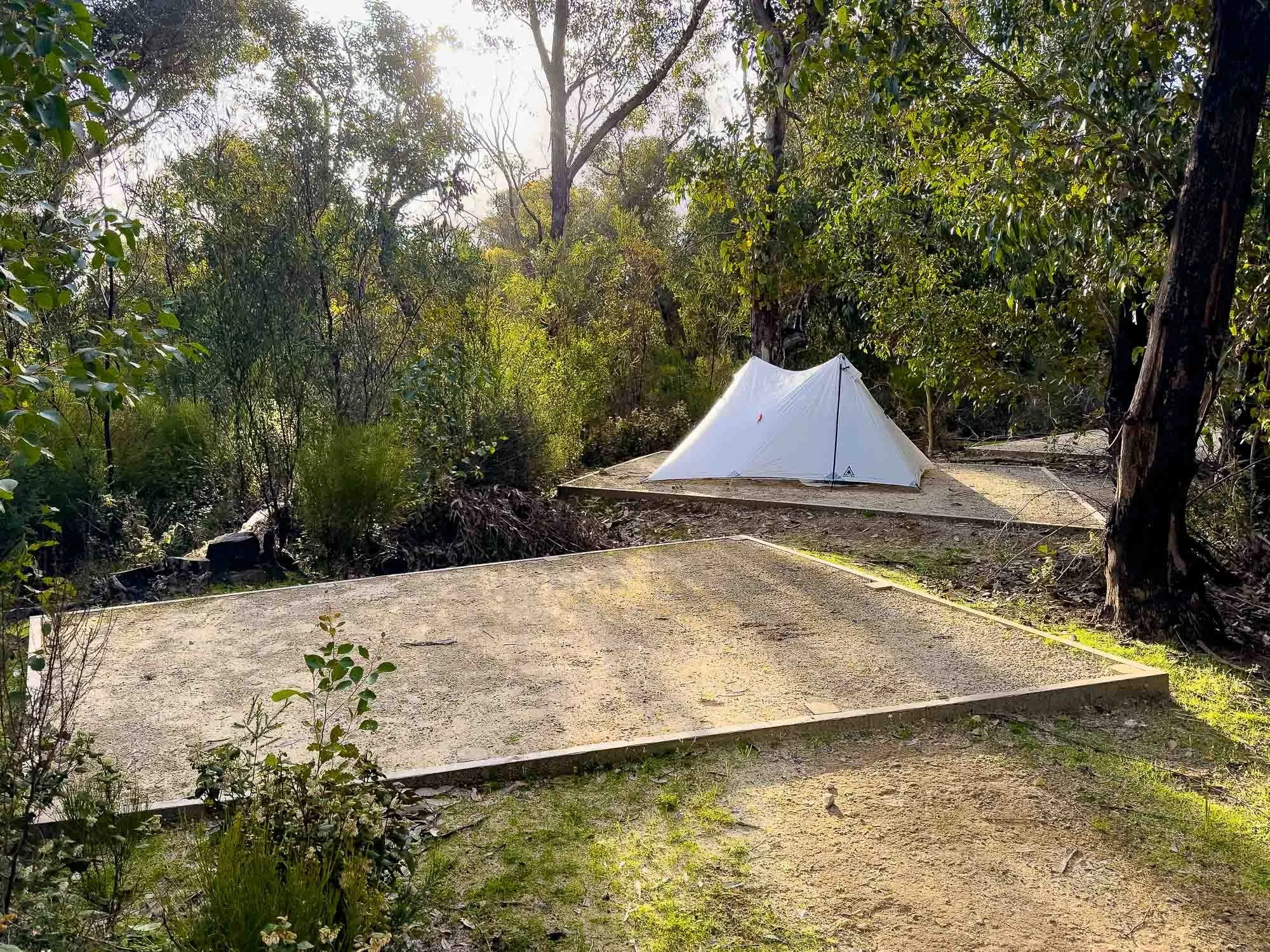
Campgrounds with a choice of sheltered tent pads or raised timber tent platforms:

When to Hike
Officially you may hike at any time of year, though summer isn’t recommended: inland sections can be extremely hot and airless and we personally would avoid December to February; total fire bans and catastrophic forecasts may require last-minute changes. We recommend in order of preference:
1. late winter to spring — late August to early November, peaking in October for wildflowers — followed by
2. mid autumn: early autumn is often still hot and dry, or
3. winter for wild spectacular seascapes
ie mid autumn to late spring (April through November).
However, weather can also be extremely cold and wet in autumn and spring. With much of the trail along exposed headlands and clifftops, pack warm and waterproof clothing at any time of year. You have no risky inlet crossings (advice for the ferry should you fall overboard is to “stand up!”), and the trail traverses the dunes for times when Maupertuis beach is scoured or at high tide.
Safety
Warm puffies, waterproof shells, beanies and gloves on a cold spring evening in camp.
Bring clothing to suit all conditions, from hot and sunny to cold and wet (see our Clothes for Multiday Hiking series). Bring or hire a Personal Locator Beacon or Garmin Inreach: there is little cellular coverage on trail. Carry a first aid kit, paper map, sunscreen and insect repellent.
Leave No Trace


Drive slowly on the entire island, especially from dusk to dawn. Respect signage on trail; clean your boots and pole tips to prevent the spread of phytophthera fungus, walk below the high tide mark on Maupertuis Beach to avoid affecting rare shorebirds, and stay off restricted headlands where native animals are breeding. If caught short between hut toilets, bury waste 20cm deep at least 60m from any water sources. Carry used toilet paper in compostable doggie bags and drop into the hut toilet. Or use a bidet and/or Kula cloth.
Supported Options
Slowerhiking is all about empowering independent hikers, but Licensed Tour group companies offer supported walks so you can hike:
fully guided staying in the campgrounds or
fully guided returning to accommodation each night (or here and here), where you’re picked up at the end of each day near the huts from a bus stop.
Some offer track highlights walks covering sections of the track. Intrepid Travel offers a women’s only trek.
Most organise all travel and transfers from Adelaide but prices for the full trail are eye-watering, between AUD3,600-AUD4,000pp due to transport requirements. Remember this when looking at independent transport options which, while still expensive, are a fraction of the cost!
Geoff pretending to wait for the bus.

When we hiked the first time, there was an option to have your pack dropped to you each night: these treats were kindly delivered by some hikers doing this!
However, this hike is eminently customisable, especially if you have your own or a hire car.
Getting There
On the ferry at Cape Jervis; Kangaroo Island’s northern cliffs visible on the horizon.
The key is to book everything well ahead, the further ahead the better.
Without a Vehicle:
Kangaroo Island is in slowerhiking’s back yard, but most hikers without a car fly to Adelaide from further afield. From there, (all at time of writing and booking nine months ahead for spring) the cheapest option without a car is (prices one way):
a bus from Adelaide to the ferry terminal at Cape Jervis ($27-$38 pp, the higher cost is a recommended direct route without stops and is booked at the same time as your ferry, below),
the approx AUD65pp ferry to Penneshaw (book well ahead, especially in school holiday periods) and then
a track transfer, AUD55-AUD220pp depending of number of people, about AUD150-AUD220pp when there are two people (double for one) to the start of the trail at the Flinders Chase Visitor Centre. Choose one of two track transfer companies. This seems expensive but, depending on time of day, it’s a two hour drive, and the driver may have to return empty.
Alternatively, fly from Adelaide to Kingscote Airport ($142 red eye special), followed by a slightly (about 17%) cheaper bus transfer — it’s a shorter distance — to the start of the trail.
With a Vehicle (Highly Recommended):
With your own car, you must pay for the vehicle’s ferry crossing — about AUD200 -AUD250 return for small to medium SUVs under 5m, more for bigger cars — but thereafter you have no transfer or shuttle fees.
If you’re following our recommended itinerary that includes three days’ sightseeing before your hike, for one or two people an option that’s not as expensive as it might seem is to hire a vehicle for 9 days (including a recommended contingency day after your hike). Hire cars from Adelaide Airport are much cheaper than on the island, AUD300-AUD500 for the same period — meticulously check fine print because the cheapest have many exclusions — when booked far in advance, but you must add those ferry fees. When traveling abroad, we arrange travel insurance to cover the large car rental excess in case of a bingle, much cheaper than the rental companies’ daily insurance; again, read fine print.
Hire cars from Kingscote Airport or Penneshaw are much more expensive, AUD730-AUD850 (latter for 4WD, prices even higher in summer) at time of writing.
Even parked for five days of the trail, the flexibility to stay in campgrounds rather than motels beforehand saves money, as will avoiding trail transfers to and from Flinders Chase (totalling AUD600-AUD840 return if there are only two of you on the bus, as is possible). If you’re happy in a smallish-medium car from Adelaide, it will be significantly cheaper than hiring on KI or using track transfers as long as you book well in advance (nine months is not excessive).
Therefore, if you plan to follow our itinerary and booking timeline, a hire car from Adelaide is likely to be the cheapest, most flexible option that also allows you to explore most of the island. Hire cars on KI are about the same as track transfers but get snapped up even earlier so book car, trail and ferry at the same time (again, seven+ months is ideal).
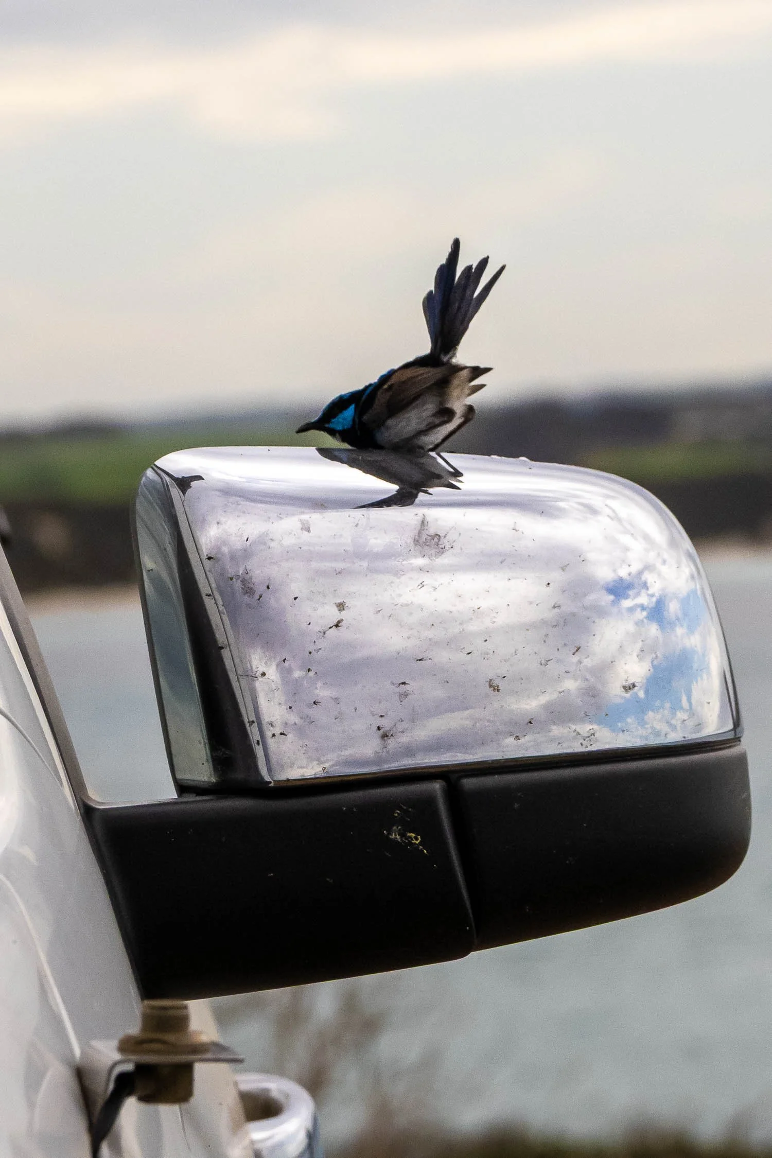
A male Superb Fairy Wren attacks the nasty challenger reflected in our car window where we’ve parked for a short day hike.
Encounters like this are typical of the island.
Park Passes and Fees
Book the trail online, AUD205pp, AUD124 child, AUD164 concession at time of writing. This includes your park entry fee, the Trail Guide booklet and Trail Map, (additional AUD15 if you want it posted to you), car parking at Flinders Chase National Park Visitor Centre, entry to Kelly Hill Caves and all other park features, and the shuttle from Kelly Hill Caves back to Flinders Chase Visitor Centre.
Book the trail many months ahead too, especially if hiking in spring and/or school holidays: numbers are capped at 16 independent hikers per day; contact the Visitor Centre for larger groups. If you plan to see Kelly Hill Caves before your hike, this is subject to availability; email or ring Flinders Chase Visitor Centre after booking your hike so staff can accommodate the change.
Depending on what else you see on Kangaroo Island, a Parks Pass may or may not be cheaper than individual entry passes to Seal Bay, Cape Borda, Cape Willoughby or other reserves.
Slowerhiking’s Leisurely KIWT (and Island) Itinerary
Rationale
There is an enormous amount to see on Kangaroo Island: it’s Australia’s third largest and, because of its relative remoteness, we highly recommend exploring it for at least three days before your hike. Even though the trail visits many iconic landmarks, you miss out on a lot if all you do is walk the trail. The entire island is chockers with wildlife and spectacular scenery:
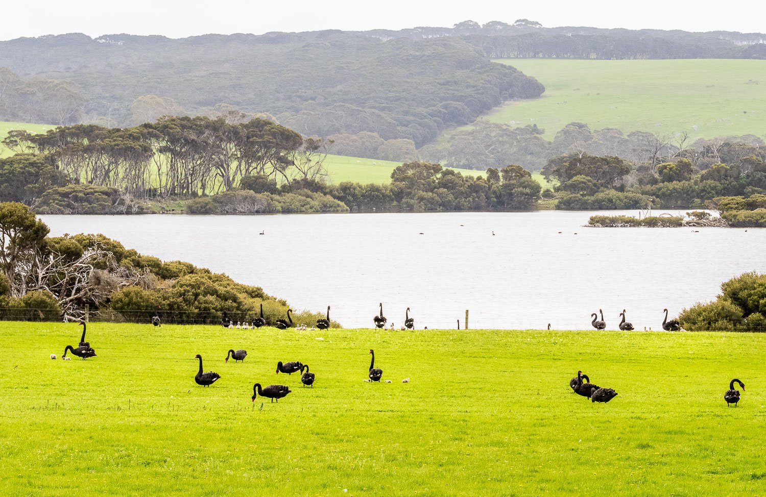
Wild black swans and cygnets in a random roadside paddock.
In addition, the current ferry does not run when seas and/or winds from certain directions are high: shortly after we arrived, all ferry crossings were suspended for several days. This happens occasionally rather than often, but you don’t want weather to kybosh your long-anticipated hike. Consider this also if you have connecting flights from Adelaide: add a contingency day to the end of your hike.
Instead, in the days preceding your hike, visit Seal Bay for up-close views and the Raptor Park to see and hold Wedge Tailed Eagles, owls and hawks. There’s also the Koala Park, an Adventure Park, the Penneshaw Penguin Centre with fairy penguin tours, gin distilleries, wineries, honey outlets, artisan cheese places and lavender Farms, spectacular short hikes and fascinating history near Cape Borda and elsewhere, and a delightful secret beach accessed through a natural rock tunnel at Stokes Bay.


Numerous tour companies run half-day and full-day Island ‘Discovery Tours’ leaving from Adelaide, Penneshaw or Kingscote, but nearly all of them overlap with the things you see on the trail and they are expensive, so we don’t recommend them for KIWT hikers unless you choose one of the indulgence winery or distillery tours!
Many of the places mentioned can be accessed via bitumen roads, so you don’t need a 4WD as is required for valid insurance on gravel. Some people drive hired AWD SUV’s on gravel, but check fine print and access roads when planning your trip. Note that travel times are much slower at dawn, dusk and at night due to prolific wildlife — please slow to 60 km/h.
As well as allowing you to explore, a hire car makes the hike easier, because you can visit Admiral’s Arch and Weir Cove after (or before) your hike instead of seeing them on Day 3 (you may need to pay an additional day fee). If visiting before, you could drop a food bag, clearly labelled with pickup date, with Day 2 dinner and Days 3-5 supplies in the stainless steel cupboards in Hakea hut. We recommend that you visit Admiral’s Arch and Weir’s Cove after picking up your car on the afternoon of your last day; you’ve already paid for park entry this day so there’s no extra fee.
The distance on the last day is only 7.5km/4.7mi over easy terrain and we think that most slower hikers will have no trouble finishing in time for the 10:30am cave tour and the 11:30am shuttle back to the Visitor Centre.
Alternatively, if you’re concerned about hike time and you have a car at Flinders Chase, book your Cave tour for the afternoon, and pop back in after picking up your vehicle and after visiting Admiral’s Arch and Weir’s Cove.
Catch your ferry or flight back to Adelaide late the following day, rather than the same day.
A 9 Day Casual KIWT and Island Touring Itinerary:
Day -3 Island Touring
Travel to Kangaroo Island, pick up last- minute supplies (fuel and hire car if flying in), sightseeing.
Day-2 Island Touring
Sightseeing around Island.
Day -1 Touring, Induction
We recommend that you see Kelly Hill Caves on Day 5 of the KIWT either immediately after completing the hike at 10:30am as walk notes suggest, or in the afternoon that day after picking up your car. However, although we think slower hikers will have no problem finishing on time if you start early, it’s possible to visit Kelly Hill Cave today only if you think it will be too rushed anytime on the last day of your hike. The Cave Tour should have been booked long ago at the same time as your hike; call or email Park staff when booking to check availability if varying from the standard Day 5, 10:30am tour.
Similarly, we recommend you also see Admiral’s Arch and Weir’s Cove on the afternoon of Day 5 of the KIWT after you’ve picked up your vehicle from the Visitor Centre (see below). However, you could instead visit Admiral’s Arch and Weirs Cove today, totalling about 500m/0.3mi from each of the two car parks, or about 4.4km/2.7mi return if you hike between the two, parking at one end; you may need to pay an additional park entry fee. If visiting today, consider dropping a food bag in the steel cupboards in the hut to significantly lighten your pack on Days 1 and 2 of the KIWT.
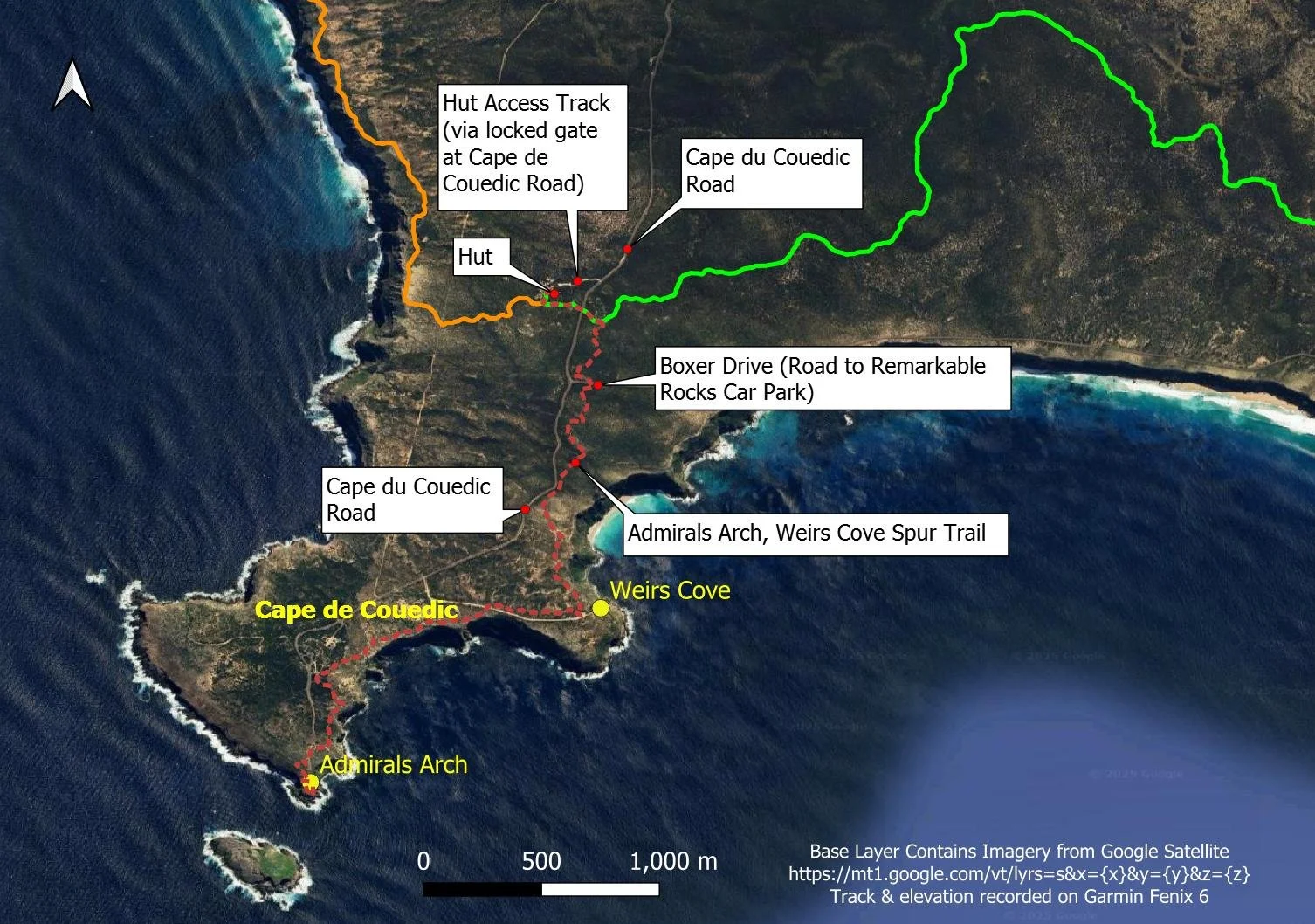
The hut is just 300m along a vehicle access track from Cape de Couedic Road.
Go to Flinders Chase Visitor Centre for your (mandatory) Induction.
We recommend camping at Rocky River Campground tonight: you’ll pass the pools mid-morning tomorrow, but evenings are the best time to see platypus. The pools are an easy 2.2km/1.4mi from camp. Book the campground at the same time you book the trail ie months ahead. Tomorrow, drive the 5.5km/3.4mi to the Visitors’ Centre for an early start on trail.
Day 1 KIWT: Visitor Centre to Snake Lagoon (Rocky River Section, 18km 7hrs*)
*National Parks and Wildlife Service SA suggested hike time; we took 8 hours
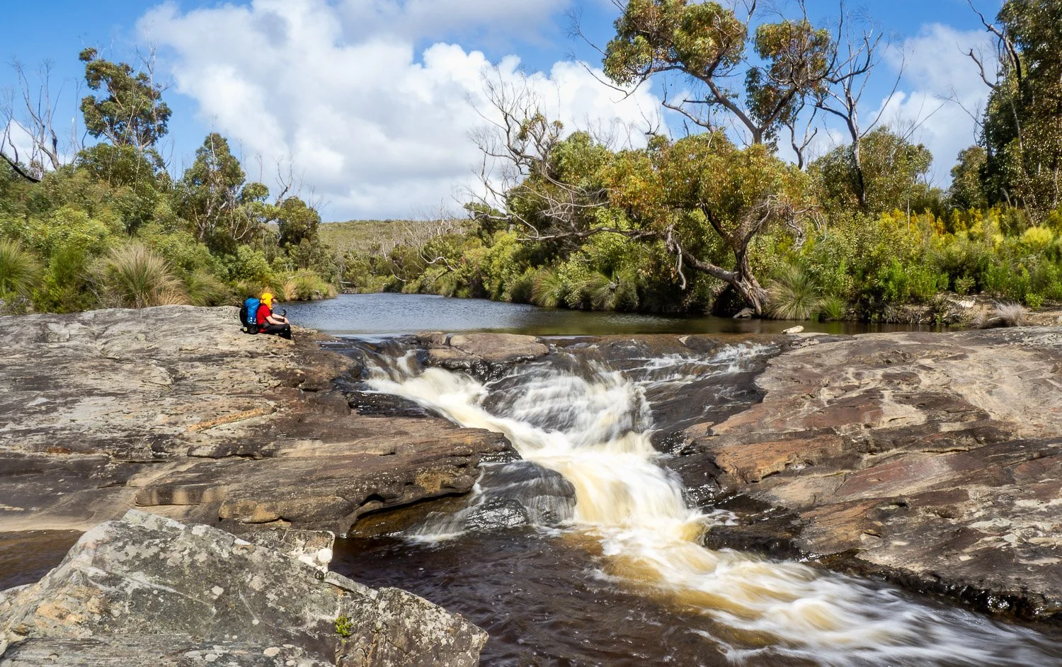
Rocky River Cascades
Start early: travel via transfer or car from your accommodation to the Flinders Chase Visitor Centre (those without a car will do the induction now), and start your hike. You’ll pass a beautiful lagoon, the platypus pools, skirt a meteor crater, climb a lookout, and pass rushy cascades along Rocky River. The woodland and wildflowers are superb, varying from forest to mallee, tea tree and heath. At the campground, watch wallabies while you eat dinner at one of the outdoor tables, and listen to the eerie cries of bush stone curlews into the night.
Day 2 KIWT: Snake Lagoon to Hakea Hut/Cape de Couedic (Maupertuis Section, 14km 7 hrs*)
*NPWS suggested hike time; we took 7 hours including our side trip to the Rocky River Outlet.
Rocky River mouth
We highly recommend the fun 1.2km/0.75mi (return) spur trail to the river mouth with its splashing waterfall and pool, great for a swim on hot days; leave your main pack at the junction and take a day pack with plb, first aid kit and essentials. If you don’t take the spur trail, view the pool from the headland. See rare shorebirds along Maupertuis Beach before ascending the cliffs and following the edge with constant views of the southern ocean — watch for whales and dolphins! — until the last 900m/0.56mi when you head inland to the campsite.
Day 3 KIWT: Hakea Hut to Banksia Hut (Sanderson Section, 13km/8.1mi, 6.5hrs*)
*NPWS suggested hike time; we took 7.5 hours (omitting Admiral’s Arch and Weir Cove, but including Remarkable Rocks and Sanderson Bay)
Watching a seal colony below the cliffs
More fantastic hiking along cliffs covered in drifts of heathy wildflowers and mallee further in. The Remarkable Rocks spur trail is just 1.8km/1.1mi (total return) and easy; if you see Admiral’s Arch and Weir Cove before or after your hike as we strongly recommend, you won’t be taking the 9km/5.6mi, 4 hr return spur trail today and will have plenty of time to enjoy Remarkable Rocks. You also have the 1.2km/0.75mi return spur trail to Sanderson Beach today; slower hikers should take the spur trail when they pass, rather than returning to it from Banksia Hut as recommended in the walk notes.
Slower hikers who try to also include Admiral’s Arch/Weir’s Cove will need to cover 25km/15.5mi and are likely to be walking for about 12.5 hours: you won’t make the distance in daylight, especially April-September. Do not underestimate the rockiness of the track.
Day 4 KIWT: Banksia to Tea Tree (Grassdale Section, 13.5km, 6.5 hrs*)
*NPWS suggested hike time; we took 6.5 hours including our side trip.

Sweeping drifts of grass and views
More spectacular cliffs today before you head inland into taller forest and sandier terrain, with boronias scenting the air and goannas lazing in sunny patches along the track. Cross the Southwest River on the fun little ferry and take the spur trail to Hansen Bay. Once you return, follow the trail beside the river all the way to Tea Tree. Nearby is the old homestead, with grazing Tammar wallabies and kangaroos.
Day 5 KIWT: Tea Tree to Kelly Hill Caves (Kelly Hill Section, 7.5km, 2.5 hrs*).

Heading inland on the last day.
*NPWS suggested hike time; we took a leisurely 3.5 hours.
Slower hikers, start early, no later than 7am. You’ll pass the small Wilderness lagoon and then the much bigger Grassdale Lagoon (twitchers, schedule time with binoculars) and tall timber country, a small area of unburned terrain. After this, it’s a short hop to Kelly Hill Cave Car Park and the terminus of the trail. Do the 10:30am Cave Tour; it leaves from the car park.
From Kelly hill Car Park, use the 11:30am shuttle transfer to the Visitor Centre to pick up your car.
Visit Admiral’s Arch and Weir Cove. We recommend you drive to the car parks and explore from there, but purists can hike the official 9km/5.6mi return spur trail from the main KIWT just east of Cape de Couedic Rd.
Drive to Kingscote, Penneshaw or your accommodation.
Those without a car can be picked up from Kelly Hill car park or the Visitor Centre by their track transfer company and returned to Penneshaw or Kingscote accommodation.
Day +1 (9) Contingency Day around Penneshaw or Kingscote
More sightseeing and, probably, eating at cafes and pubs! Fly or take ferry and car/bus back to Adelaide.
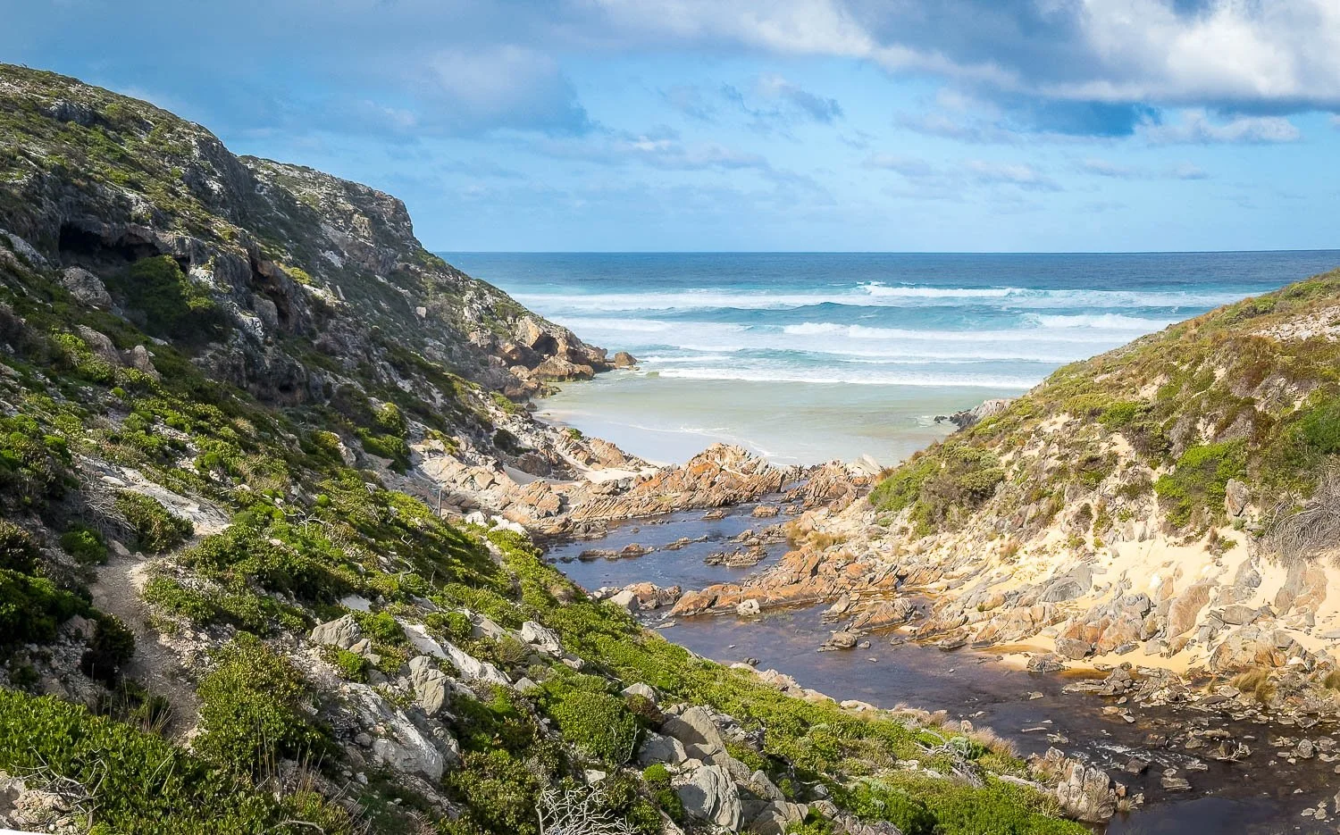
Turquoise water and golden sands. Stay tuned for Daily walk blogs, coming soon.