Hakea Trail - Planning and Tips
We recognise and acknowledge the Goreng, Menang and Wudjari people as the traditional owners of Fitzgerald River National Park.
Spectacular sea views, plus a seat from which to enjoy them!
Why Hike the Hakea?
The Hakea track in Fitzgerald River National Park traverses Western Australia’s rugged and spectacular southern coastline in an area renowned for its flora and fauna, comparable to the Galapagos Islands in diversity. It is amazing.
The world heritage-listed Fitzgerald Biosphere, with the 330,000ha park at its heart, contains over 2,000 plant species plus dozens that occur nowhere else; it’s home to an incredible 20% of Western Australia’s plants! It also has 22 mammal species, 41 reptile species and over 200 bird species - more than any other reserve in the southwest! - making it the cherry on Western Australia’s diversity hotspot cake.
Botanists, ornithologists, entomophiles and herpetologists will all love this hike, as well as the stunning coastal views that accompany them. Geologists will enjoy the fascinating rock formations. If you’re a nature-lover visiting Western Australia, don’t miss this park and, if you’re a leisurely hiker, keep reading for our alternative more relaxed itineraries to the standard schedule.
The region’s famous - and famously rare - Qualup Bell (Pimelea physoides) occurs nowhere else.
Vegetation also varies greatly within the park - we hiked the completely different Manang Trail (coming soon), as well as exploring inland and roadsides surrounding the Park for orchids and other wildflowers.
When to Hike
Prime wildflower season is September to November; the wonderful Ravensthorpe Wildflower Show is held in September each year. In terms of wildflowers, we were a scant 10-14 days early due to a late-breaking season, with numerous species in late bud rather than the carpeting kaleidoscope of colour the park is famous for. Nevertheless, other than on the beaches, not a step went by without something in bloom at our feet and I was not disappointed.
We experienced perfect albeit windy hiking weather; in summer, the track will be exposed and hot.
Nearly all of the hike is highly exposed either on beaches and through coastal heath, so you’ll be in sun most of the time. Summer and early autumn can be extremely hot, and rainwater tanks at Whalebone Hut potentially dry. Winter provides wild seascapes but fewer flowers, although something will be in bloom at any time of year.
Tide Times
Check tide times to plan your walk - beach distances are relatively short so you can work around them. Beaches around Hamersley Inlet and to the east are shallow, with high tide reaching the dunes at the time we hiked in September. While it would be possible to hike behind or on the foredune, this causes erosion, damages vegetation, and would be much more strenuous.
The most recent high tide reached the foot of the foredune, but we are hiking at a better time.
Leave No Trace
If you’re caught between toilets at huts or carparks, please bury your waste away from the path and 20cm deep. Mix the poo and soil with a stick before burying to speed decomposition. Folk with vaginas, please consider using a Kula cloth for pee, or pop your used pee paper in a ziploc bag that you keep with your toilet paper, hand sanitiser and trowel - pee is sterile, so it’s perfectly hygienic to carry out used paper in a sealed bag.
We all know not to pick wildflowers, but preventing the spread of phytophthera, the introduced fungal disease that kills plants in the Proteaceae and Myrtaceae families, is even more important. This means using boot cleaning stations wherever you see them, and sticking close to tracks.
Boot Cleaning Station at Hamersley Inlet
Getting There
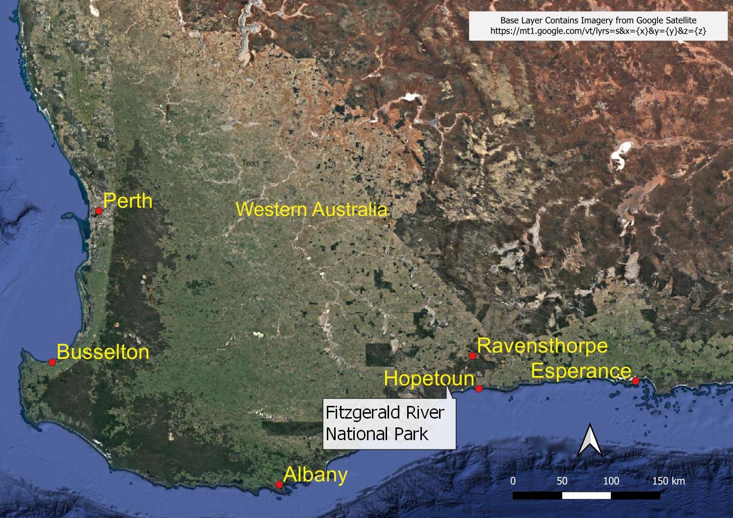
Fitzgerald River National Park is midway between Esperance and Albany on the south coast of Western Australia, approximately 550 km from Perth. There are two small towns located close by. Ravensthorpe is near the north eastern boundary of the park and Hopetoun is on the eastern boundary on the coast. Both towns have basic supplies such as groceries, hotels, cafes, hardware, fuel and a small range of accommodation options.
Ravensthorpe and Hopetoun are accessible by regional bus, but the park is large (just under 3,300km2) so you still need a car to get to the trail head; for us it was approximately 60 km from the park entrance to the trail head!
When we prepared this blog there were no car hire, taxi or track transfer options in Ravensthorpe or Hopetoun, so you will need your own or a hire car to reach the trail head. Car hire is available from Albany (300 km to the west) or Esperance (200 km to the east). Both of these large regional centres have flights to and from Perth as well as regular bus services.
Locality map for the Fitzgerald River National Park
Track Configuration
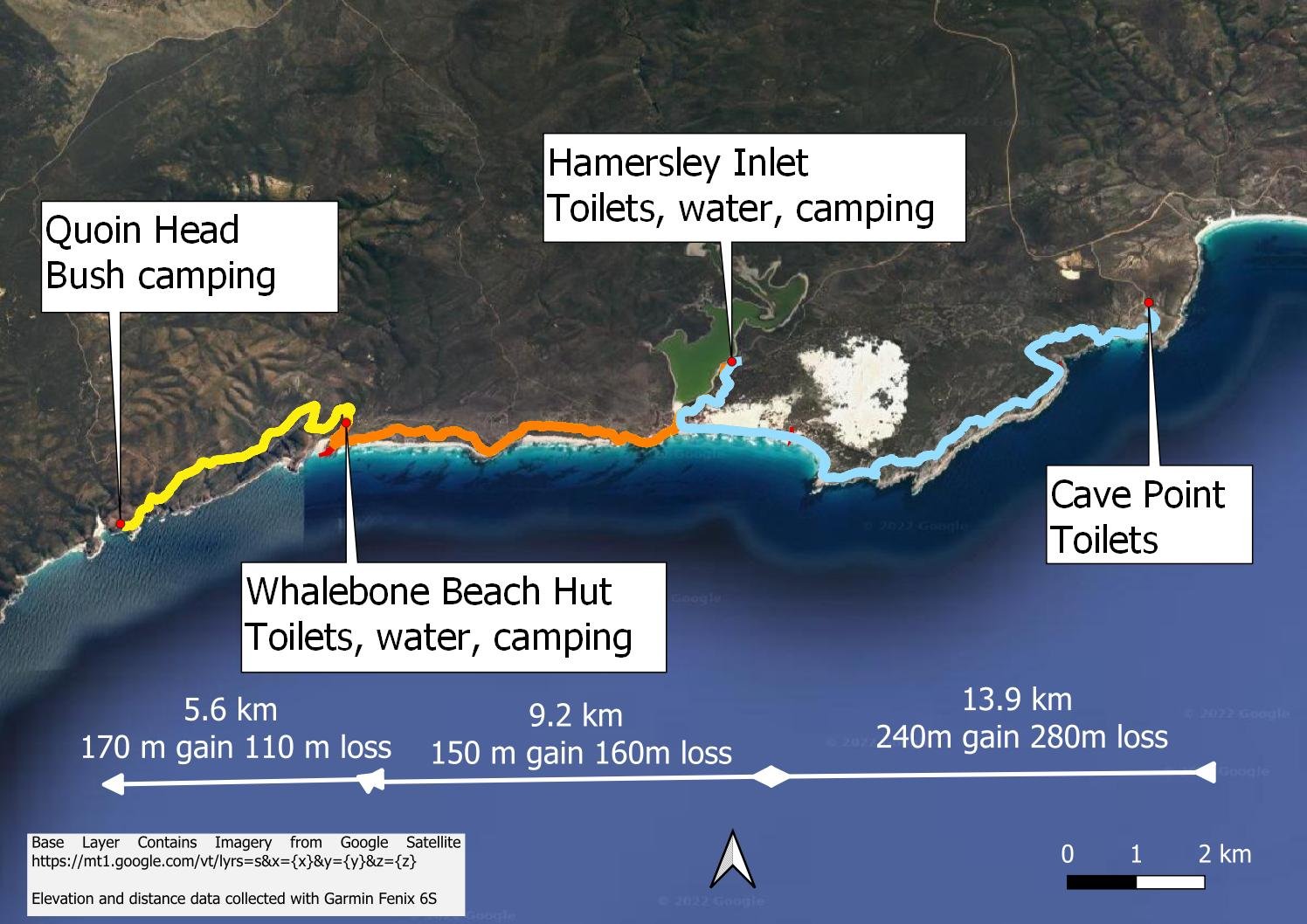
The hike is promoted as an out and back hike from Cave Point to Quoin Head. The total distance is 46.8 km, with around 1000 metres elevation gain and loss.
The main trail head is at Cave Point. There are toilets there, but no camping facilities.
A secondary trail head leaves from Hamersley Inlet which is 13.9 km from Cave Point. You access the Hakea trail from Hamersley Inlet by a 1.8 km spur trail (which we’ve included in the 13.9 km distance).
Hamersley Campground has good camping facilities, water and toilets, all about 200 metres from the start of the trail access spur. It is a mixed camping site run by the local Shire Council, so you’ll likely share the space with the odd car camper or even a caravan or two. Whilst the camping area and trail access point at Hamersley Inlet are off the main trail route, it is a pleasant detour and a good way to shorten the first day, whichever way you plan to do the hike.
View over Hamersley Inlet from the spur trail
The main Hakea Trail camp site is located near Whalebone Beach, approximately 18 km from Cave Point. That campground has a toilet and excellent hut that would sleep at least 16 people, but with limited campsites if you prefer tenting. When we hiked, we were the only ones in the hut so space was no problem. It’s difficult to imagine the hut filling up: we were hiking in prime wildflower season, during the popular Ravensthorpe Wildflower Festival!
Whalebone Beach Hut
Park maps indicated that water was not available at Whalebone Hut but there are rainwater tanks and a seasonal fresh water stream nearby; water availability should not be an issue if you are hiking in winter or early spring. Summer and autumn could be a problem.
Quoin Head (the third trail head) is only 5.6 km from Whalebone Beach Hut. We are advised by Parks that three small tent sites are available there. The campground is actually a 4WD camping area but road access to Quoin Head is problematic so the site is not promoted. For the most part the 4WD track is easily accessible, but there is a steep section towards the end that becomes badly rutted.
Hakea hike distances and elevation summary: one direction only.
However, the bigger issue for hiker transport logistics is that the track into Quoin Head is often closed at very short notice as Parks try to manage the spread of phytophthera. Basically, vehicle access is closed in wet seasons and after any period of decent rainfall (irrespective of the time of the year). So whilst car camping is possible, you can’t rely on vehicle access to Quoin Head. On the other hand, it is therefore a quiet bush camp for Hakea Trail hikers. We are not aware of any water availability at the camp site.
Sign on the rainwater tank at Whalebone Beach Hut; we recommend sterilisation tablets or a water filtration system rather than boiling, which uses extra fuel.
Alternative Itineraries
We think there are three most likely itineraries for leisurely hikers. You might like to work around one of them to suit your specific needs as we did.
Note that all the elevation gain and loss information is approximate only - estimated from my Garmin Fenix 6S watch recordings.
Option 1: 5 days 4 nights
This is our recommended approach for leisurely hikers which results in a five day hike with two nights at Whalebone Hut and another two nights at Hamersley Inlet. It provides time to complete the spur trail lookout, a lazy afternoon at Whalebone beach, and also the opportunity to explore Quoin Head beach which is a short (but steep) extension to the trail.
Beautiful sandy beaches - this one near Cave Point
Day 1: Cave Point to Hamersley Inlet. Details: distance 13.9 km, elevation gain 240 metres, elevation loss 280 metres
Day 2: Hamersley Inlet to Whalebone Hut. Details: distance: 9.2 km, elevation gain 150 metres, elevation Loss 160 metres
Day 3: Whalebone Hut to Quoin Head and return to Whalebone Hut. Details: Distance 11.2 km, elevation gain and loss 280 metres.
Day 4: Reverse of day 2, camp at Hamersley Inlet
Day 5: Reverse of day 1.
Option 2: 4 days 3 nights
This option involves bush camping at Quoin Head, so hopefully one of the three available spaces is free when you arrive. If the road in is closed then that’s likely. You will need to fill up with enough water at Whalebone Hut as you go past to get you to Quoin Head and back, including enough for dinner and breakfast. The option doesn’t really allow you time to explore Whalebone Beach; you should check/verify your hike plan with the Parks Ranger at the Albany Parks and Wildlife Office well before starting.
Rugged coastal views - Quoin Head
Day 1: Cave Point to Hamersley Inlet. Details: distance 13.9 km, elevation gain 240 metres, elevation loss 280 metres.
Day 2: Hamersley Inlet to Quoin Head. Details: distance: 14.8 km, elevation gain 320 metres, elevation loss 270 metres.
Day 3: Reverse of day 2 camp at Hamersley Inlet.
Day 4: Reverse of day 1.
Option 3: 3 days 2 nights
This option is the conventional Hakea Trail option. It involves bypassing Hamersley Inlet on day one and going all the way to Whalebone Hut. You stay at the hut overnight and the next day do a day walk to Quoin Head and back. You’d have time to check out the beach at Quoin Head, or alternatively Whalebone Beach, staying overnight again at Whalebone Hut. Day three you return to Cave Point.
Stunning rock formations through which you’ll have to weave
Day 1: Cave Point to Whalebone Hut. Details: distance 17.9 km, elevation gain 380 metres, elevation loss 410 metres.
Day 2: Whalebone Hut to Quoin Head and return to Whalebone Hut. Details: Distance 11.2 km, elevation gain and loss 280 metres.
Day 3: Reverse of day 1.
The Hakea Trail is promoted as a simple out and back Grade 4 hike but we found it offered much more than that. And there are a range of alternative approaches to tackling the hike that become even more flexible if you have two cars.
Whilst you need your own car to get there, the remoteness from large population centres means that its wild and rugged coastline with big seas can be appreciated in solitude. And our leisurely approach meant Helen could linger over her plant photography. In any case, this is such a biodiverse area within the south west of Western Australia that it makes no sense to rush through it!
With the benefit of hindsight, we’d spend more time exploring and appreciating the beaches at Quoin Head and Whalebone Hut: make sure to leave room in your schedule for at least one of them.
Follow each day by clicking on the buttons below.


