
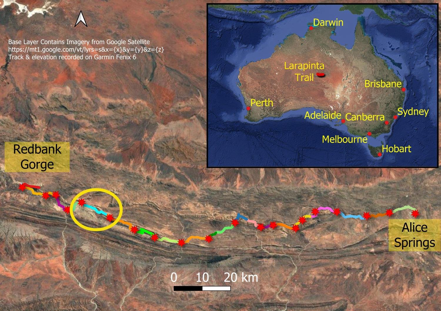
Ormiston Gorge to Hermit’s Hideaway/Giles Lookout/Waterfall Gorge (Day 7, Sect. 9 Part)
Plains, geology, wildflowers and spectacular ridgeline views

Glorious sunset views over Mt Giles
Today’s marvellous walk is between 12.5km/7.8mi and 15.7km/9.8mi depending on where you stop: one wild high camp, one designated intermediate high camp, both with spectacular views, and one designated low camp with a pretty rock pool. None of the camps have huts or toilets. Waterfall Gorge often has water, but not always: check before leaving Ormiston Gorge as you may have a big water carry ahead of you.
If you’re following our itinerary, compare your times to ours each day or check the table in Itinerary. That way, when you reach the more demanding sections around Standley Chasm, you’ll know whether you will be faster or slower than us on those days, and whether you need to allow more time. All up, including rest stops, sightseeing and meal breaks, this day took us 6.9 hours to get to Hermits Hideaway. Then another two hours the following morning to get to Waterfall Gorge campsite on our way to Serpentine Chalet.
Zooming along the trail (slowerhiking style)!
You initially follow Ormiston Creek before winding through the rolling southern foothills of the Heavitree Range with interesting geological formations, and then climb steeply to the ridge. Once you reach it, you follow it for a couple of kilometres with vast views to Mt Giles and beyond to the north and the Pacoota Range to the south. After travelling 2km/1.25mi along the spine of the range, you pass Hermit’s Hideaway tucked under sheltering trees just south of the escarpment edge, followed by more exposed sites at Giles Lookout about 1.2km/0.75mi further on. From there, despite the apparently quick 2.1km/1.3mi, it is a steep, slow descent and there’s a short rocky climb to Waterfall Gorge. If your bowels are amenable, avoid pooing at High Campsites because even a toilet trowel won’t make a dent.

There is also a campsite (Base of Hill Campsite) at the, well, base of the climb, but this will make tomorrow’s distance to Serpentine Chalet Dam too far for slower hikers.
How to Make Today Easier
Section 9 of the trail is graded Difficult, rockier and rougher than Moderate/Difficult Sections 12,11 and 10. You have a steep climb at the end of the day even if you stay at one of the closer high campsites. We therefore strongly recommend that slower hikers choose Giles Lookout (13.7km/8.5mi) as a designated intermediate high campsite, or Hermit’s Hideaway (a wild high campsite) as a safer option in windy weather if you can’t make it to Waterfall Gorge (15.7km/9.8mi). There is also a camp at the base of the hill before the climb for emergencies, but this will make your next day too long.
You’ll need to carry water for the day, night and breakfast, before topping up at Waterfall Gorge early tomorrow — provided of course that water is present! Your overall trip planning should allow for there being no suitable water at Waterfall Gorge tomorrow: check with east-west hikers before heading off. Topping up at Waterfall Gorge is your lightest and easiest option.
Although Waterfall Gorge is just 2.1km/1.3mi past Giles Lookout, you have a steep descent followed by a rocky creek and climb, and the going is likely to be slower for you than the distance implies (particularly if you’re carrying extra water). We recommend that, weather permitting, slower hikers choose one of the two high camps, reserving Waterfall Gorge only for strong wind days. Giles Lookout reduces tomorrow’s long day slightly, Waterfall Gorge more so. Serpentine Chalet Dam is another 16.4 km/10.2mi (from Hermits Hideaway) with a decent amount of elevation gain and loss including sections of steep terrain, definitely out of reach for slower hikers in a single day from Ormiston Gorge.
Walk with Us

You begin southeast in the shade of cliffs bordering the wide bed of Ormiston Creek, passing the turnoff to the Pound Circuit that you followed yesterday.

After about a kilometre you leave the creekbed into the lower foothills of the Heavitree Range. Today brings many marvellous geographical features: in the background, you can see the folds of ancient sea beds in the hills.

The wildflowers are amazing after rain, here a glade of Wilson’s Grevillea.

Second breakfast on the side of the track.

Free Carpel Fire-Bush (Seringia nephrosperma), named for its kidney-shaped seeds in the centre.

Central Australian Daisy Bush (Olearia ferresii)

Much of the trail is rocky: not difficult, but you have to literally watch every step.

A few short steep bits here and there.

Another fascinating rock formation.

Plenty of iron in this terrain!

These ultralight hiking umbrellas clip to the shoulder strap of your pack. You can buy proprietary clips, or make your own from two spring cord locks and lengths of bungee. It also takes a little while to place them properly in terms of height and angle so they don’t bump against the side of your face; large-breasted women will find it more difficult to get the angle of the umbrella upright.
Our relatively small (60L and 70L) ultralight packs tuck neatly just under the back edge of the umbrella, but those with bulkier conventional packs will need to raise their umbrellas.

You can see just how effectively the umbrella shades the body, and the attachments mean you can still use your trekking poles. The lower the umbrella sits above your head, the more area it shades.
An umbrella like this is also useful in rain: you still need a rain jacket, but can use a much lighter weight one with a lower hydrostatic head because the areas that are most susceptible to seepage — shoulders, upper back and straps — are protected from much of the moisture.

Lunch in the shade of mallee trees, surrounded by a small cluster of campsites that form Base of Hill Campsite. I sometimes leave the umbrella attached, lean my pack against a tree or rock, and use it as a backrest.

You can see how the trail is rarely flat in this picture. On the left is an ochre deposit.

Switchbacks on the steeper sections: yay!

Across a little flat…

and finally on the spine with grand views to the north for the first time today.

At your feet, just look at that incredible camouflage — even the eyes are the same colour! This is the Common Toadhopper, Buforania crassa.

Most Wilson’s grevilleas (G. wilsonii) are scarlet red, but now and then you’ll spot one like this in glowing orange.

As is the case in all the elevated sections of the trail, the path is rocky and uneven underfoot, but it’s hard to keep your eyes on the ground when the views are so fantastic!

Here and there, the track braids: I think the official trail goes along the narrowest, rockiest section of spine but here we have dipped onto the southern side. When this happens, don’t stress. Check your map or app and, chances are with a parallel trail, it will rejoin the main one.

Beautiful spinifex thriving in even the rockiest areas. What an amazing plant, with clever adaptations to survive the dry.

Looking east along the Heavitree Range to the knob of Giles Lookout at its end. You can see why the Giles Lookout campsites are so exposed to weather; conversely, Hermit’s Hideaway wild camp is tucked amongst a cluster of trees partway along, south of the rocky edge that forms a protective wall.

View of Mt Giles. If you hiked the Ormiston Pound Loop yesterday, you could have extended it as an overnight hike to Mt Giles (experienced hikers only as it’s an unmarked route with unreliable water). If we were doing the trail again with recent rain, we would schedule in three or four days and include this side trip to explore spectacular deep gullies tucked into Mt Giles’ sides.

Amongst the trees at Hermits Hideaway, which was reclassified as a wild campsite after we hiked, though it has been well-used for a long time as an intermediate campsite. The views are even better at Giles Lookout, but Hermit’s is more sheltered. Go for Giles unless Hermit’s is safer due to weather.

For comparison, here are a couple of the campsites at Giles lookout; another has a low rock wall on one side. All of the sites are in the “acceleration zone” where wind speeds increase as they bend and tumble over the crest; even the walled site on the lee side in southerly winds is likely to be in rotor. So make a decision as to where to stay when you reach Hermit’s Hideaway: stop immediately if it’s windy and you don’t think you can make Waterfall Gorge; continue to Giles Lookout in good weather or, if you still have fuel in the tank, continue on to sheltered Waterfall Gorge.

Preparing dinner with a view. I’m sitting on the raised rock edge of the escarpment: it shelters the campsites on the southern side from northerlies, and the trees and shrubs filter the wind from all directions.

We stayed in the high camps wherever possible: yet another glorious sunset behind Mt Sonder.
We respectfully acknowledge the Arrernte People as the traditional custodians of the land on which we walk and pay our respects to Elders past and present and to the Aboriginal people present today.