
Little Ramsay to Zoe
We respectfully acknowledge the Bandjin People as the traditional custodians of the land on which we walk. We pay our respects to Elders past and present and extend our respect to the Aboriginal people present today.

Zoe Falls, today’s destination.
Today’s hike is somewhat longer at 10.5 km, up to a saddle followed by a long downhill and interesting swampland. Enroute there are a few opportunities for a swim or bathe.
If you’re concerned about this distance with a climb in hot weather, you could spend the previous night at Banksia Bay instead of Little Ramsay as described in yesterday’s trip report. That would even up the distances, a little longer yesterday and then just 9.1 km today. You will still have the same amount of climbing to do but won’t need to wait for tides so could head off early to beat the heat.
After a little beach, an estuary to wade and a rocky headland, today’s terrain is primarily inland with forest, swamp, saddles, and river crossings. A short side trip to Banksia Bay is an option to enjoy the scenery there.


Mt Bowen bids us good morning in the soft easterly sunlight. This lagoon is incredibly inviting but it’s obvious that it’s easily accessible to saltwater crocs.

We have a longer day today, but we are in no rush. Time for a relaxed brekky and a chat, because one of the joys of hiking is also the company you keep.

We begin along the beach. A hammerhead shark is lazily cruising up and down not far out. More things with sharp teeth in the water!
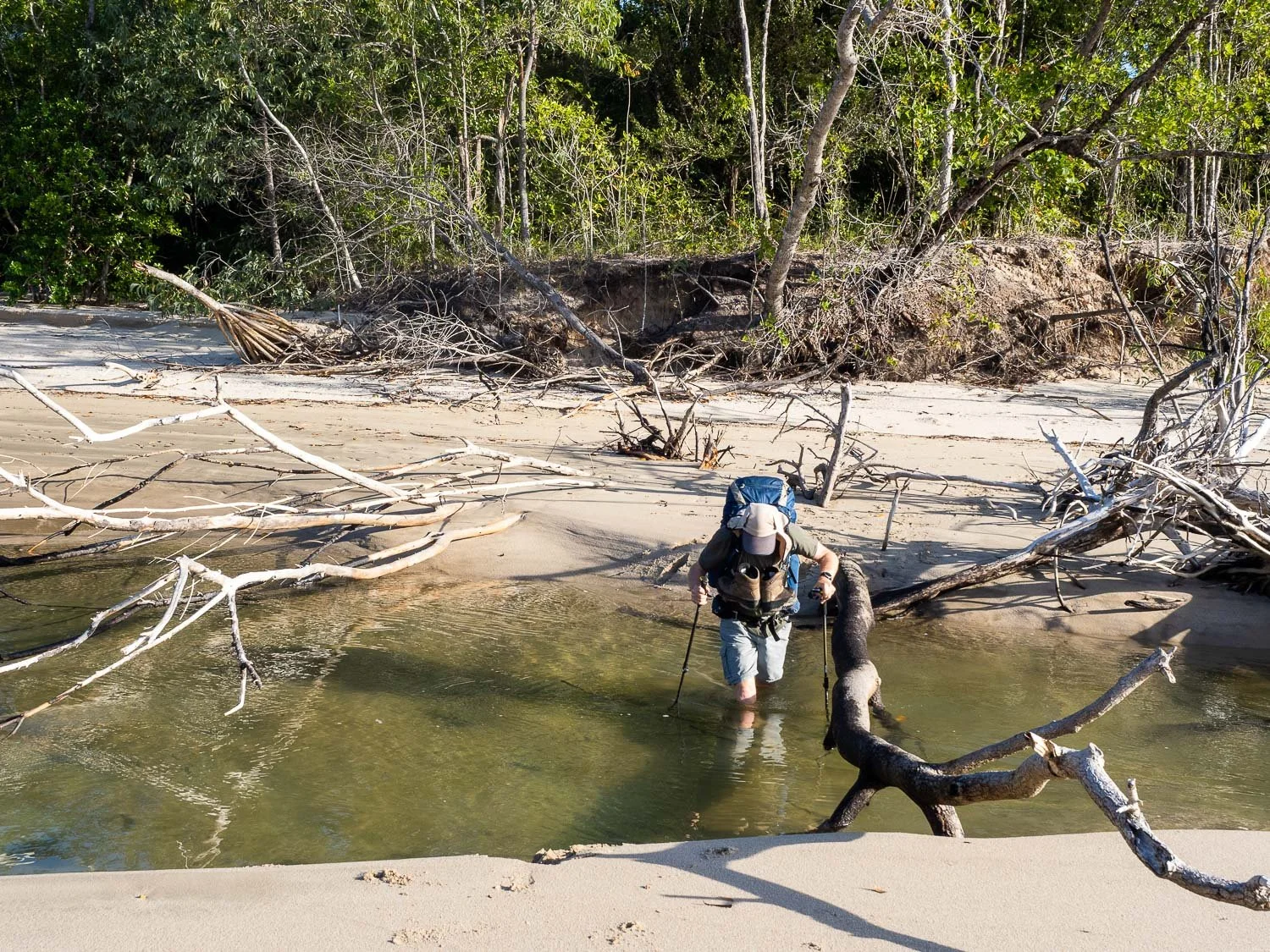
Another of the reasons we didn’t hurry breakfast is because we know that we have this small estuary to cross at the end of the beach. As it is, we wait another half hour or so for it to recede a little further before crossing because it’s nice to see the bottom as well as up and downstream; we southerners are more paranoid about crocodiles than the locals!

The estuary we crossed feeds into this lagoon, hidden just behind the beach. This walk has numerous secret treasures, including many culturally significant ones.

At the southern end of Little Ramsay Beach is a short rock scramble. At low tide, you’ll be able to walk around the headland on the sand, but it’s still too high for that today. The bank of trees in the background at the edge of the beach screens the lagoon in the preceding photo.

Over the headland is another tiny beach, at the end of which a rocky creek empties into the sea. Follow this creek upstream a short distance to find a small rockpool perfect for a refreshing bathe.

We take the opportunity to refresh in this lovely natural spa just up from the beach. The mosquitoes are fierce so we don’t linger!

Over another headland onto a third beach. The trail markers are regularly placed; along these headlands we’ve generally been able to see the next marker from each preceding one, other than where the track is unmistakable.

View back towards Little Ramsay Beach, Nina Peak and Mt Bowen.

And now we say goodbye to beaches for a while and head inland into shady forest. It is warmer today and the respite is welcome.

Not least because soon we are climbing… and climbing.

As we climb, the vegetation changes from shady forest to more open heath. Phew, it’s hot!

We reach the .45km spur trail to Banksia Bay and decide to head down for a look, leaving our packs at the intersection. It is a steepish descent but the beach is quite different, with small mangroves colonising the corner. The rocky headland offers interesting views. There are also fabulous golden orchids in the area but, like the others I’ve seen over the last few days, none are in flower; the best has been one plant in late bud.

Banksia Bay campground with a makeshift table. The sites are again well-spaced and flat. Remember you’ll need to carry in water from Little Ramsay if you decide to stay here for the night.
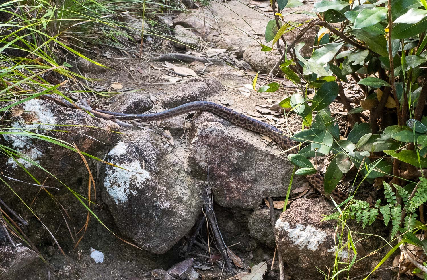
Up the spur trail and back onto Thorsborne, and this beautiful spotted python (Anteresia maculosa) is sunning on the track. There are about half a dozen species of snake on the island, including the green tree snake, a couple of sea snakes, two more pythons and the death adder.

More climbing. It’s hot and steep, but fun terrain. We’re following a drainage line, probably a dry tributary of Banksia Creek.
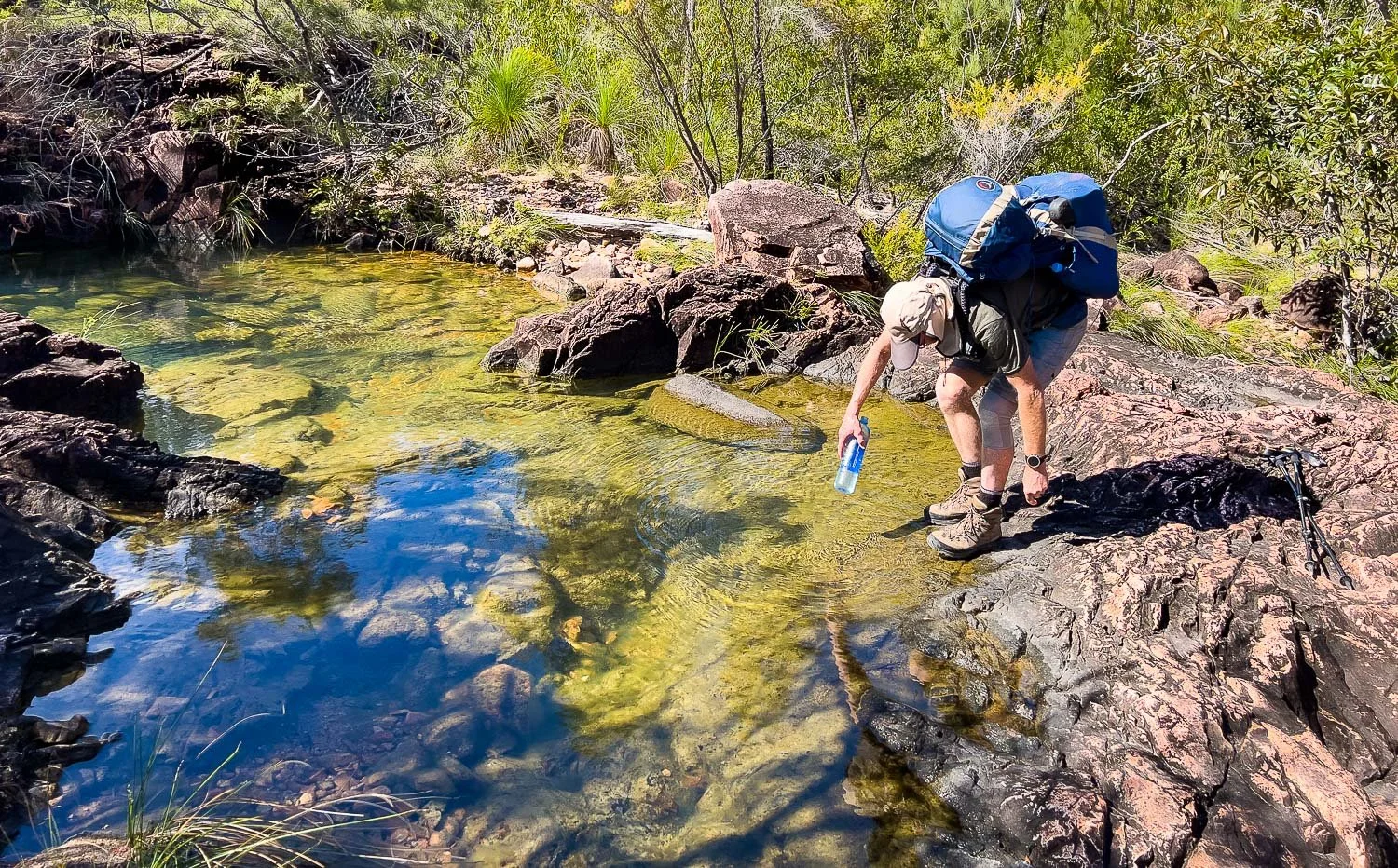
We take the opportunity to top up our water bottles here at what must have been Banksia Creek. This spot, about 400m past the Banksia Campground spur trail, isn’t marked on the maps, probably because it is ephemeral and therefore unreliable. You won’t find a reliable water source for a further 3 km, so if you do camp in Banksia Bay make sure you bring plenty of water to get you well into the following day’s walk.

We finally reach the saddle with spectacular views across the swamp to Zoe Bay. A long, rocky track is ahead but, hooray, we’ve done our climbing for the day and now it’s all downhill!

Chloanthes parvifolia

Guinea Flower (Hibbertia melhaniodes)

As we descend, we’re back into rainforest. The constantly changing nature of this hike over such short distances makes it so unique, and so much fun.

And then, suddenly, we reach the edge of the forest and are into yet another environment, open swampland studded with paperbarks.

The trail skirts the edge of the swamp: imagine this in the wet season! It’s tempting to make new trails on drier ground but grit your teeth and go straight through the mud, or the track gets ever wider, more braided and more subject to erosion. Epiphytic orchids perch high above on the branches of the paperbarks.

You’ll see many rocky creeks and lagoons on this flatter terrain, edged and dotted with those magnificent paperbarks.

Although this year had record flooding in areas of Queensland and New South Wales, the creeks are low here: they rise quickly but also fall quickly. The algae-covered rocks below the surface are extremely slippery.

When you look skywards in the forest, the light filters through a vast array of textures to delight the eye. Here, the spectacular Australian Fan Palm (Licuala ramsayi var. ramsayi).

And more creeks to cross. Keep an eye out for Cypress Pine Creek, the final one before you reach camp.

Fifty metres or so upstream of where the track crosses Cypress Pine Creek is a small waterhole known as Blue Lagoon, with sun-warmed rock slabs at the near end to lie on. Delightful. When we arrived, we were somewhat disappointed as it looked very shallow, perhaps a metre or so deep. However, we were completely misled by the water’s astonishing clarity: it is at least 2.5-3m at its deepest point, and you can see the bottom easily. In southern Australia where eucalypts are the dominant tree cover, their tannins stain the water like tea so that even in pristine pools it can be hard to see much. Here, the water is a glorious, well… aqua!

After your swim, it’s another four kilometres or so to Zoe Bay Campground but it is flat and relatively easy terrain when we hiked; the low-lying areas would be much more challenging in the wet or after rains. You’ll have time to make a cuppa and set up the tent before going to see Zoe Falls.

More flat, shady campsites. The following evening, our little tent was surrounded by those of a water polo team, so it didn’t look quite the same!

Zoe Falls with that extraordinarily clear water. And no crowds: we have the entire lagoon to ourselves, at least for the moment, because the day trippers have all gone home. Time for a quick dip in this little corner of paradise, before heading back to camp for dinner…

And a beautiful sunset over Mt Bowen. What a day, what an incredible day, filled with banner memories.