
Thorsborne Trail Overview and Planning
We respectfully acknowledge the Bandjin People as the traditional custodians of the land on which we walk. We pay our respects to Elders past and present and to the Aboriginal people present today.

Gobsmackingly beautiful Mulligan Falls: just one of many spectacular experiences on the Trail
The Thorsborne Trail is an exceptional 32 km thru hike on Hinchinbrook Island in tropical Queensland. The entire island is uninhabited, uncleared National Park, refreshingly without a single resort in sight.
Because the island is mountainous, you not only experience its wide empty beaches and rocky headlands, but also vast views over lush swamps, rainforest and estuaries. You’ll take a breather on heathland peaks and saddles, and walk in the quiet deep shade of tropical jungle. You’ll swim in crystal pools with inquisitive perch nibbling your toes, while gobsmackingly beautiful waterfalls thunder down beside you. At night, you’ll have a campsite amongst the trees, often within a stone’s throw of the beach.
This trail is unique – in its wildlife, vegetation (many species, such as the blue banksia, occur nowhere else), in its variety, and in its beauty.

You’ll do some rock scrambling depending on tides: this was very manageable
Terrain
The distances are short and very doable for leisurely hikers but don’t be misled: the trail is surprisingly demanding. At times the beach sand is soft; you’ll have a little scrambling here and there. Some parts are very steep with large steps over tree roots, sections of rock hopping, and slippery rocky river crossings that were easy when we were there but which can be dangerous during high flows. The swampy areas and floodplains can involve extended wading.

Heavy rain causes rivers to rise quickly.
Many are rocky and very slippery - wait for the level to drop if you’re unsure.

Rocky river crossing: low and straightforward here, but potentially treacherous at high flow. You can see how slippery the footing is.

Our friend has fun on the rope scramble beside Zoe Falls

Another short scramble
Estuarine crossings are sandy rather than rocky, but you can’t cross them when they are deep because of saltwater crocodiles. Shallow crossings mean good visibility!

We waited for the water level to drop here, not just for ease of crossing but so that we would be able to see crocodiles
It’s essential to time the crossing north of George Point carefully as you’ll be in chest deep water if you get it wrong.
Finally, many southerners will find the humidity and heat challenging, especially on the sunny beaches or in the rainforest where the air is still. Take rests, drink plenty of water, and avail yourself of all the safe swimming holes (not the sea)!
Direction
We walked north to south and would recommend this direction as each day becomes more spectacular, with your last two days at the waterfalls, with glorious views between them, followed by a restful short downhill and beach walk to complete the hike.
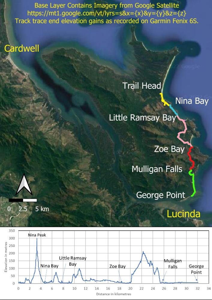
Overview map: 32 km with 960 metres elevation gain and loss
Itinerary
Our recommended 6-day, 5-night itinerary is, as always, for leisurely hikers... and this hike is tailor-made for us folk! In any case, this is not a track to rush in heat and humidity. And with so few people allowed on the island at any one time plus a competitive booking system, for many this will be the one and only chance we get. Pause at the peaks, soak in those views, explore the rocks and enjoy the plentiful wildlife. You may need to wait for tidal rivers to fall before you can cross, so this can increase time needed for certain days.
Although the sea and estuaries are dangerous, certain rock pools at the falls and elsewhere are safe, crystal clear and we guarantee that your swims in them will become banner memories. A relaxed itinerary and short distances between campsites means you can take a dip in the afternoon when you arrive, and again in the morning before you leave… and in pools you pass during the day as well! Make time to enjoy all aspects of this wonderful trail!
Day 1: Trail Head to Nina Bay, climbing Nina Peak enroute (5.4 km including 0.65 km each way to Nina Peak).
The Nina Peak climb is steep and rocky; it is also likely to be hot, so give yourself plenty of time and take water with you.

Steep climb up the spur trail to Nina Peak: the views are worth the effort!
Day 2: Nina Bay to Little Ramsay Bay (2.7km).
You’ll arrive early but you have lagoon surrounds to explore (not safe for swimming), the beach to walk, and you’ll be rock hopping a slow section between the two campsites. Little Ramsay Bay is a delightful campground but, if you’d prefer to walk further, you could stay at Banksia Bay, which is off a steepish 0.45km spur trail 1.8km further along the Thorsborne.
Banksia Bay is a much smaller campground and has no water supply so you’ll need to collect it from the creek feeding the lagoon in Little Ramsay Campground and carry it with you. There is occasional fresh water about 400 metres past the Banksia Bay spur junction on the Thorsborne Trail, as well as a little rockpool for a splash if Banksia Creek is running, otherwise its 1.3km from the spur trail junction before you can refill on your way to Zoe Falls the following day. This would make your second day 5 km and your third day 9.1 km.
Because you book the trail rather than individual campsites, you can decide which campsite to stay at when you arrive at Little Ramsay.
Those who have a permit to hike the challenging Mt Bowen side route will leave from Little Ramsay.

The beautiful lagoon beside Little Ramsay Campground
Day 3: Little Ramsay Bay to South Zoe Bay (10.5 km).
You bypass Banksia Bay (or pop down for a look as we did, taking a daypack with plb, first aid and water, but leaving your main pack at the junction), then stop for a swim at the Blue Lagoon which is only 50m upstream of where Cypress Pine Creek crosses the track.
If you have time, walk to Zoe Falls for another swim when you arrive in camp!

Swimming with jungle perch at Zoe and Mulligan Falls: the fish are friendly!
Day 4. Indulgence Day at Zoe Falls
Most descriptions recommend two nights at Zoe Falls and there is good reason for this. It’s a short hike to the falls from the campground, but you will not only want to swim in the glassy pool at the bottom (bring goggles!) but also continue the Thorsborne Trail to the top and soak in the famous infinity pool. Many people like to catch the sunrise here as well.
Alternatively, if you spend only one night at Zoe Falls, leave early the following morning and enjoy breakfast on the rocks above the falls.

Ridiculously beautiful Zoe Falls
Day 5. Zoe Falls to Mulligan Falls (6.7km)
Leisurely hikers may want to stop for lunch at the saddle, or down the hill at Diamantina Creek, before heading to Mulligan Falls.

Glorious views on Day 5 between Zoe Falls and Mulligan’s Falls
Day 6 Mulligan Falls to George Point (6.3km)
This short easy day is a relaxed finish. We elected to be collected late so we could enjoy another swim at Mulligan’s in the morning, but it will depend on tide times as there is another estuary crossing. Don’t be late and miss the low tide: chest deep wading is incredibly risky in crocodile infested waters.

A cruisy walk along the beach with one estuary to cross at low tide… chest deep at high tide would be much more exciting, and not in a good way!
When to hike
The track can be hiked year-round but it is insanely hot and wet in summer: April through September is recommended. We hiked in June and found it hot, although all the local mainlanders were complaining of a cold snap! June-July is the best season, when rainfall and temperatures are lower.
In the wet season, or straight after heavy rain at any time of the year, many of the rivers become impassable. Late in the dry season, water availability away from the main campsites could become an issue if you were to rely on it:
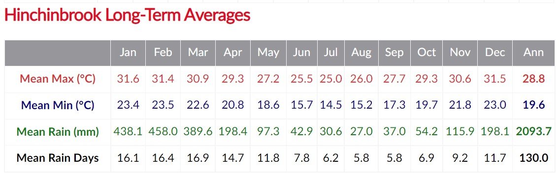
Ideal times to hike are quickly obvious from this table (https://www.eldersweather.com.au/climate-history/qld/hinchinbrook )
Campsites
Campsites are sheltered, flat and well-spaced:

Many of the campsites - Nina Bay, Banksia Bay, Little Ramsay, Zoe and others - are a stone’s throw from the beach.
Pack racks allow you to hang your packs out of reach of goannas and native rats; don’t hang your pack from tree branches as you’ll damage the latter. Bring a pack cover or liner bag for rain.

All campsites have “pack racks” to foil goannas and native rats!
We used our Triplex tent, neoair Xlites plus our summer quilt – it can get surprisingly cool and we needed it every night. The substrates were all firm sand, a bit rooty in places, and easy to peg with msr groundhogs.
There are no huts at campsites but you’ll find drop toilets at each of them. Some have picnic tables.

All campgrounds allow two night stays except Mulligan Falls, which is one night only.

All campsites have long drop hybrid composting loos. You pump the lever for a flush.
Fresh Water
Pristine creeks and rivers close to most campsites provide excellent fresh water; reliable sources are marked on Park maps. Neither Banksia Bay nor George Point have fresh water, but you can pick some up enroute if you choose to stay there. We didn’t treat the water except at Zoe Bay campsite – the island is uninhabited – but some people may prefer to use Aquatabs or filters throughout.

Collecting water enroute.
Maps and Resources
Cardwell Visitors Centre
We loaded the Cardwell (8161) 1:100,000 topomap onto to our phone through AVENZA
The trail is also on Alltrails.
For plant lovers, John Beasley’s Plants of Tropical North Queensland (The Compact Guide) is a handy resource.
Booking and Registration
With a current cap on hikers (40/day) and number of nights (5), registration is extremely competitive for the peak season. An additional 20 spaces for commercial tour guides is proposed in 2025-2026.
Reaader Michael Eardley comments below that the booking system has changed in 2025:
“QPWS announcement about the introduction of a new booking process means no bookings can currently be made for the Thorsborne Trail from the night of Thursday 24 July 2025 onwards.
The new booking process will re-open from 1st April 2025 for booking 24 July 2025 onwards.
Full details here: https://parks.desi.qld.gov.au/parks/hinchinbrook-thorsborne/about/thorsborne-trail-permit-releases
“Note the following proposed booking schedule:
When do you want to hike the Thorsborne Trail? When will permits be released?
24 July to 31 December 2025 Tuesday 1 April 2025 – AEST 9am
1 March to 31 July 2026 Tuesday 6 January 2026
1 August to 31 December 2026 Tuesday 2 June 2026
(and get fingers ready for a mass booking panic every 6 months!)
You still book the entire track, which you can do over up to five nights, ideal for leisurely hikers, and what we recommend. Only Mulligan Falls Campsite has a one night limit.
We were lucky in that friends who so love the track that they have hiked it an astonishing five times, offered us spare tickets when two in their group couldn’t make it. Thank you Martin and Diana for thinking of us!
How to get There
If you’re not driving, fly to Townsville or Cairns, then get a train or bus to Cardwell; if you’re driving, you can also stay at Lucinda. We took the Spirit of Queensland train which runs between Brisbane and Cairns four times a week. It was simple, comfortable and we enjoyed a glass of wine on the return trip. The bus runs more frequently. Stay overnight in the motels or campgrounds in these lovely coastal villages. Some of the motels will collect you from the train station, handy if you have more luggage than your pack and can’t walk the short distance into town (we stayed at the Cardwell Beachcomber Motel & Tourist Park and they will pick you up provided you ask them a day or so ahead - check with others before you book if staying elsewhere).
The following day, boat charters like Hinchbrook Island Cruises will take you to the start of the track in either the north or south, and pick you up from the opposite end.
Depending on operator and location, boat departures and pickups are often timed to avoid low tide so will vary. The boat journey in itself is wonderful and may include turtles, sharks or dugongs.
Book everything well ahead of time.

You’ll need a charter boat ferry to the island
Navigation on the track

The route is largely well marked with orange arrows for southbound, and yellow ones for northbound. They are attached to trees and rocks.
We mostly just used a hard copy of the parks trail map that we downloaded free from the web and printed. It had all the critical things you need but occasionally we checked our Avenza and Alltrails maps for more detail. The track in the main is easy to follow; the trickiest bits are at the end of the beach sections. Even so they are marked so just keep your eyes open, the track will either go over rocks around a headland or head inland, typically at 90 degrees. And you can download the trail app if you want to cover all bases.
Tides and River Crossings
Brad of Hinchinbrook Island Cruises gave us an in-depth natural and cultural history during our transfer to the Island, safety aspects, as well as a basic map and tide timetable to help schedule our river crossings on the island. Ensure you know when low tide is for the relevant days on the track.
What To Bring
Water bottles (4L pp/day in hot weather)
First Aid Kit that includes snake bandages, lignocaine, electrolytes and an emergency blanket
PLB and/or Inreach Satellite Communicator (NB: sat comms may not work in the forested areas and there is very limited to zero cell phone reception on most of the trail: do not rely on your mobile). Buy or hire a PLB for a tiny price that could nevertheless save your life. An Inreach will work anywhere with open sky and allows 2 way comms. Carrying both provides the widest range of options.
Map and tide timetable
Sunscreen and Insect Repellent
Long-sleeved lightweight, light-coloured collared shirt, plus shorts and gaiters or long pants
Warm fleece
Rain jacket
Swimwear, or underwear that doubles as such
Hat, sunglasses, swim goggles for Zoe and Mulligans so you can watch the fish!
Camp cooker and fuel (no fires are permitted), food, tent, sleep system and sleepwear
Toilet paper, lightweight trowel, ziplock bag for used paper, rubbish bag
Waterproof pack liner
Torch/headlamp, camera/powerbank, cables
If rain is forecast, a lightweight silnylon or dcf tarp for sitting under in camp is handy.
Biting and Stinging Things
Saltwater crocodiles and jellyfish:
Under no circumstances swim from those inviting beaches. Saltwater crocodiles regularly eat tourists who incorrectly believe they aren’t sufficiently tasty. And equally dangerous are the tiny but deadly Irukandji jellyfish.
DO NOT SWIM in estuarine lagoons or deep rivers directly open to the sea, or deep, murky ones anywhere. Don’t set up your tent or loiter near the edge of a sandy bank on a deep, murky estuary: Darwin will select you for such decisions!

You’ll see signs like this near beaches and estuaries. Heed them!
Snakes
Like the rest of Australia, Hinchinbrook has snakes. The usual precautions of shoes, socks and long loose pants or shorts and gaiters offer protection. You’ll see goannas around the campsites. They’re perfectly harmless – stand quietly so as not to frighten them away, and enjoy watching them wander through.
Lawyer vine (Calamus moti) and Hairy Mary (C. australis)
These vines and canes drape innocently through the jungle and their thorns will hook you firmly and be painfully reluctant to let go. Stay observant to avoid them.
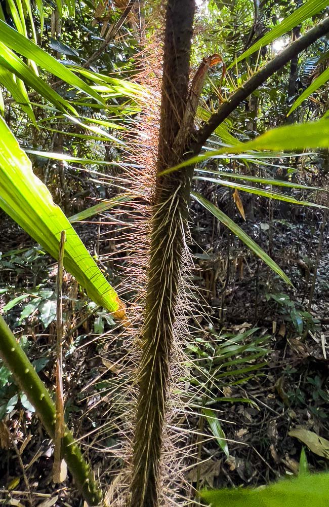
Hairy Mary (Calamus australis) - gets its hooks into you and won’t let go!
Midges:
Sandflies, midges, no-see-ums – these insects are so tiny that you rarely see or even feel them biting. Wear long sleeves and long pants, or apply insect repellent regularly, remembering that if you’ve just slathered on repellent and/or sunscreen, you can’t swim in the pristine waters. I missed just one application over three hours because I didn’t want to apply it before swimming in the Blue Lagoon. Big mistake. When they bite, they inject a protein to which most people react, some more severely than others. I got hundreds of bites on thighs and arms and, six weeks later, they still hadn’t completely stopped itching. Carry lignocaine as well as insect repellent!

Do as we say, not as we do, or you’ll end up with thousands of bites! This was a week later!
Leave No Trace
This pristine environment needs to be cherished. Please clean your boots, tent pegs, hiking poles and tent floor or footprint at home before your trip so as not to introduce awful diseases like phytophthera die back. Check also for seeds and insects in camping gear.
If you’re caught short between campsites, dig a 20cm hole at least 30m (100 ft) or as far as practicable from water and the trail, and 15-20cm (6-8 inches) deep. Make sure you can re-find the track! Carry out all rubbish including food scraps. Ladies, carry your used pee paper in a Ziploc bag and empty the bag into the toilet at camp, or use a pee rag.
If you’ve recently applied sunscreen or insect repellent, use a bottle of water and cloth to wipe it off before swimming.
Leave cultural artefacts such as middens and fish traps undisturbed. Stay on the trail. Respect significant locations.
Enjoy!

Mulligan Falls