
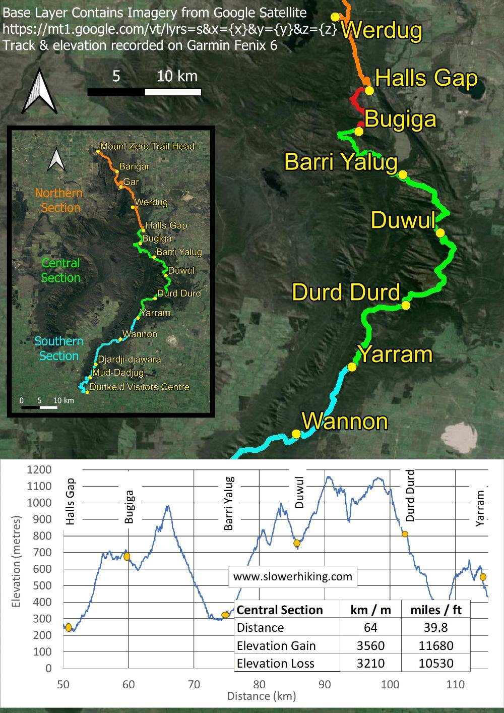
Halls Gap to Bugiga
We respectfully acknowledge the Djab Wurrung and Jardwardjali people as the traditional custodians of the lands and waters of Gariwerd.
Rockpools and waterfalls, narrow gorges and rugged tors, views and wildlife make for a spectacular start to the central section.

Expansive lunchtime views over Halls Gap and beyond from the escarpment beside Pinnacle Lookout.
Today’s 8.9 km walk climbs streamside past waterfalls and through narrow gaps to the top of the Wonderland Range, with its fantastical rock formations and vast views eastwards. You’ll follow the undulating spine for a few more kilometres before descending the western side to Bugiga campground. Although the distance is short, it’s demanding: you start with a 5.5km (3.4 miles) steep climb of 600m (1950ft) to the Pinnacle. Don’t worry: the ascent will fly by with rockpools and waterfalls to enjoy — you can even stop for a swim in Venus Baths! — and this popular section of track into the aptly named Wonderland Range is well formed with steps and good surfaces. It’s the easiest day of the Central Section. Here are the maps for today:
Overview map
How to Make Today Easier
You have five different ways to split this day to make it easier. The most demanding part of the hike is the morning’s steep climb from Hall’s Gap to the Pinnacle.
If you are in a group with two cars, shuffles make your options a breeze. Alternatively, use a track transfer company (eg Experience the Grampians) to take you — expensive but convenient. Book well ahead. All these transfers allow you to hike the day in reverse so you go downhill into Halls Gap rather than climbing.
The Mt Rosea Car Park is about 800m past Bugiga campground. In our opinion, the best option is to drive or get a transfer to this carpark in the late afternoon of your last rest day in Halls Gap and hike the 800m (0.5 miles) into Bugiga, with only 30m (100ft) elevation gain. The next day, hike the GPT northwards to Halls Gap, with only a little elevation gain and a long descent. Stay that night in Halls Gap, then return to Mt Rosea Car Park the following day to head south to Barri Yalug.
Alternatively, transfer to the same car park, but hike the entire distance north back to Halls Gap, passing Bugiga campground on the way. The next day, return to the same carpark and continue on to Barri Yalug. Of course, if you choose this option, you miss out on staying in Bugiga Campsite.
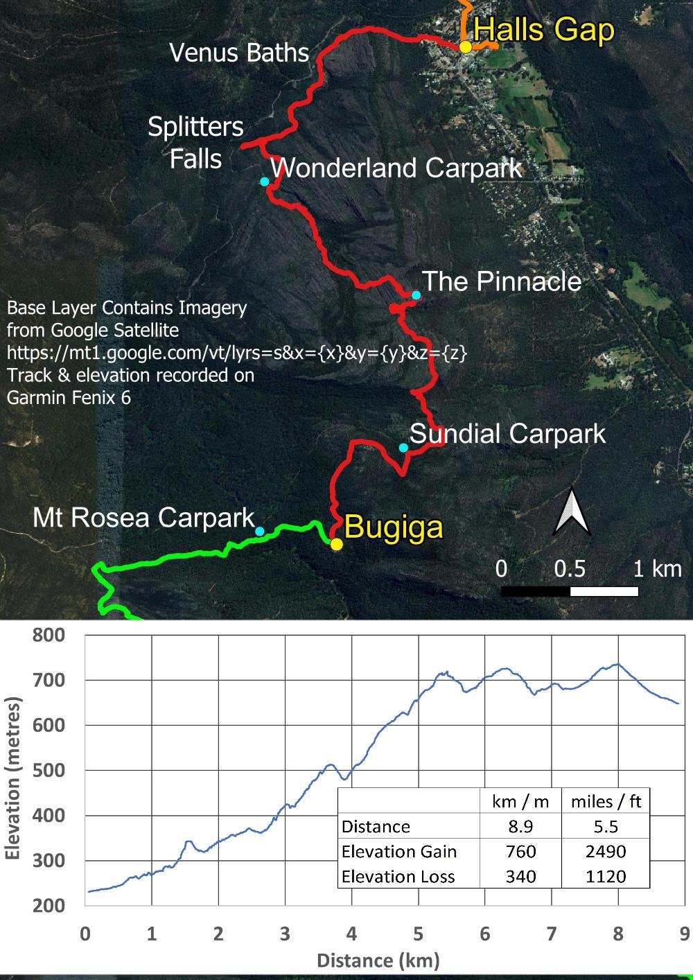
Elevation profile and route map with drop off locations and key points of interest
A shorter transfer to the Wonderland Car Park halves the climb out of Halls Gap by tackling this section in reverse northwards — ie downhill! — on one of your rest days in Halls Gap, and then another shuffle/transfer the next day to the same spot when you head south on the GPT.
If you prefer to hike nearly the entire distance in reverse and downhill, go to Sundial Car Park. You’ll hike northwards past the Pinnacle and into Hall’s Gap, then return to the same car park after a rest and at the end of the following day to continue southwards on the GPT, with just 1.5 km to hike into Bugiga. This option has the least elevation gain.
All the above options are ideal for hot weather too, not least because you’ll be passing Venus Baths and rockpools at the perfect time for a dip.
There is one more option. When we hiked, the Grand Canyon was (still) closed with a broken ladder at its top end. However, once the ladder is repaired, you will have a marvellous loop to complete on one of your rest days, climbing through the Canyon and then descending back along Stony Creek. When you start for Bugiga the next day, get a transfer to Sundial Carpark, do a short out and return to the Pinnacle (or do it the previous day) and then continue south to Bugiga.
You can also make this day easier by lightening your pack with an extra food drop. if you have a food drop at Jimmy Creek at the end of the Central Section, an earlier drop at Borough Huts Campground means you will only be carrying two days’ worth of food at the start of your hike instead of five. Because of the elevation gain on the first two days of the central section, and the scrambly nature of the second day, a lighter pack can make a big difference.
Walk with Us:

You begin in the heart of Halls Gap but within minutes the town is hidden as you climb the valley between boulders.

You’ll follow Stony Creek, serene now but with churning white wildwater after rain.

This famous section of track is good underfoot: you’re climbing, but you have stone steps and even handrails in places. Start early to beat the crowds.

Inviting rock pools all along the track

Venus Baths, perfect for a dip on a hot day. No one is here at this early hour.

Off a short spur trail is Splitter’s Falls, flowing today and spectacular after rain.

Scattered orchids about, here the Purple Cockatoo, Glossodia major

Just look at that track, so delightful underfoot as it follows the creek. Enjoy it while it lasts: tomorrow will not be the same!

A small bridge takes you over the creek and past cascades.

The hatched area in red and the no-go pictogram indicate a broken steel staircase that has been out of action since 2017. It was being repaired when we visited and should be open mid-2024, when the GPT will be re-routed through the Grand Canyon, for an even more stunning first day.

The beautiful Grampians Parrot Pea (Dillwynia oreodoxa) is one of many species that occur only here. Botanists will love the Trail.
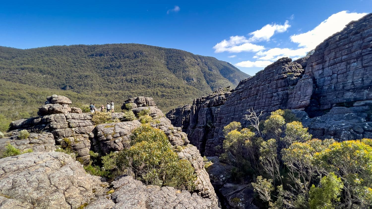
You emerge into the open and think, “Nearly there!” No, you are not, so take your time and enjoy the fissured tors and rock formations, many of them cutely named such as ‘The Lady in the Hat!’
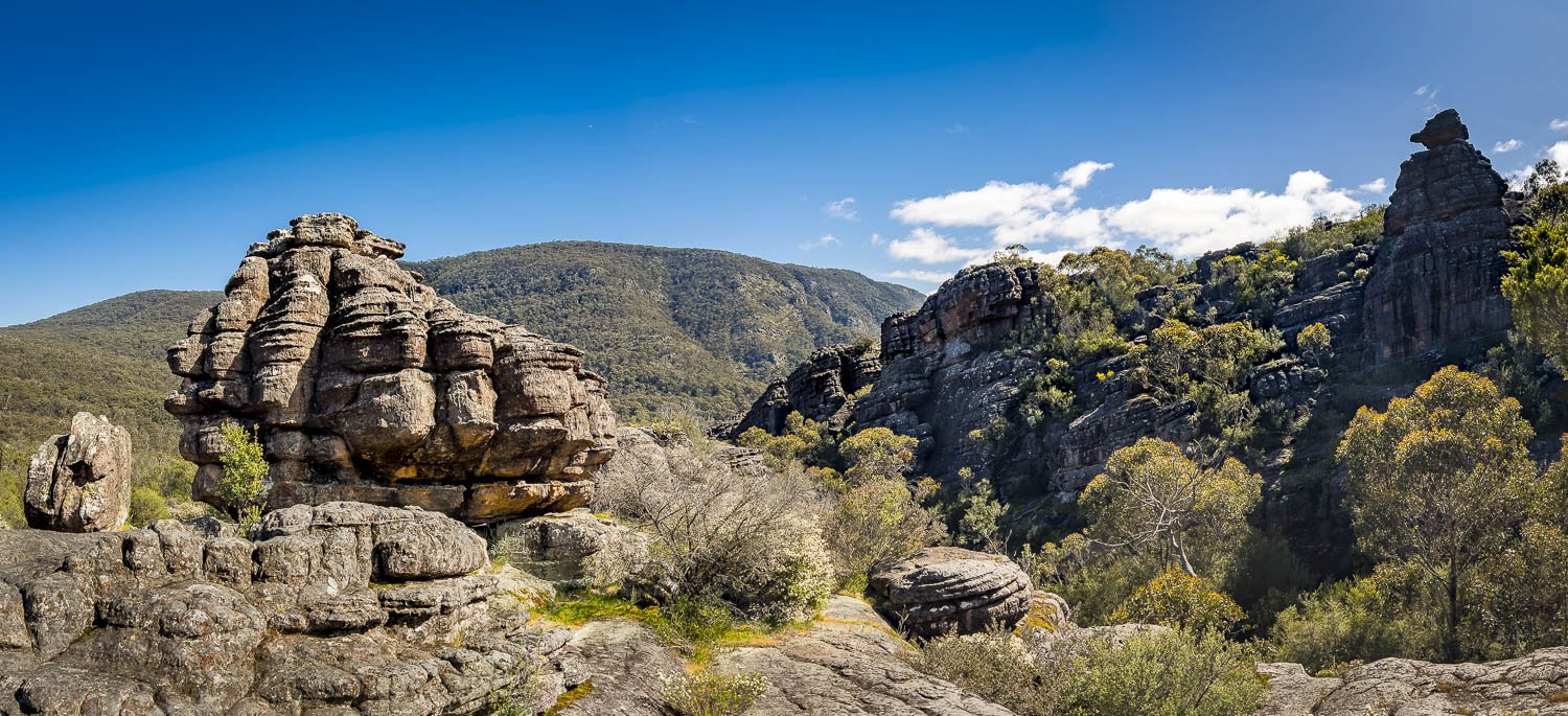
It’s already glorious, and just when you think it can’t get any more spectacular, it does!

More well-constructed track.
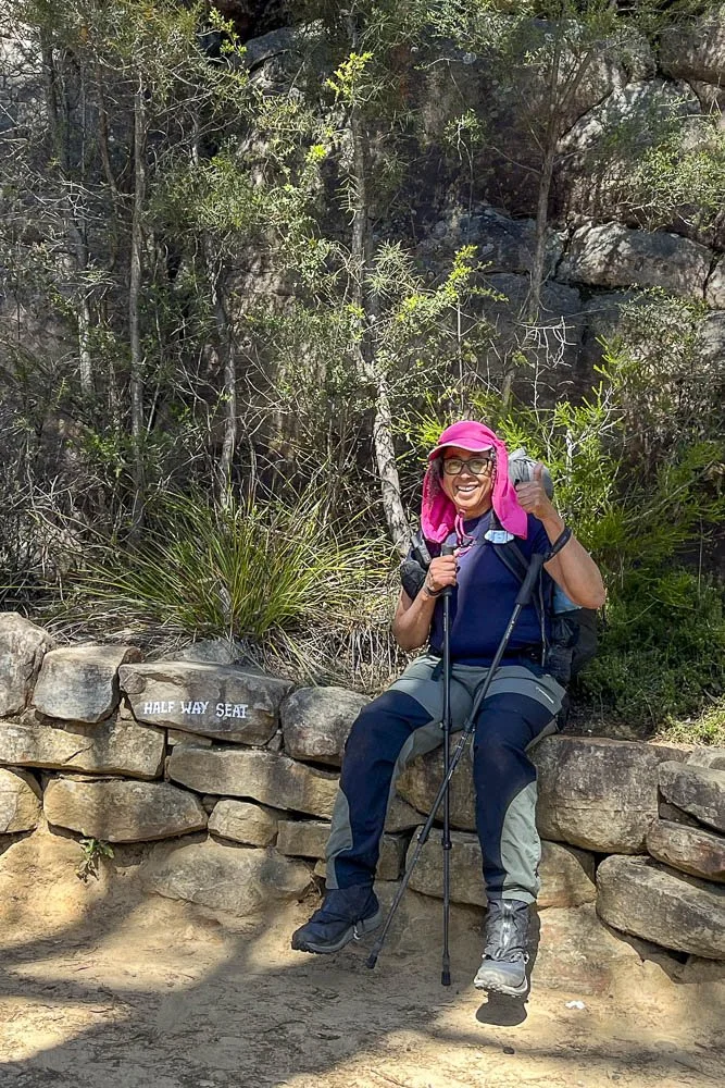
Halfway!
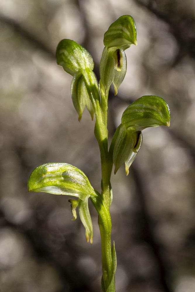
Grampians Greenhood (Pterostylis macilenta) hiding in dappled shade under bushes. There are several similar species; this one is recognisable by the bristly labellum.

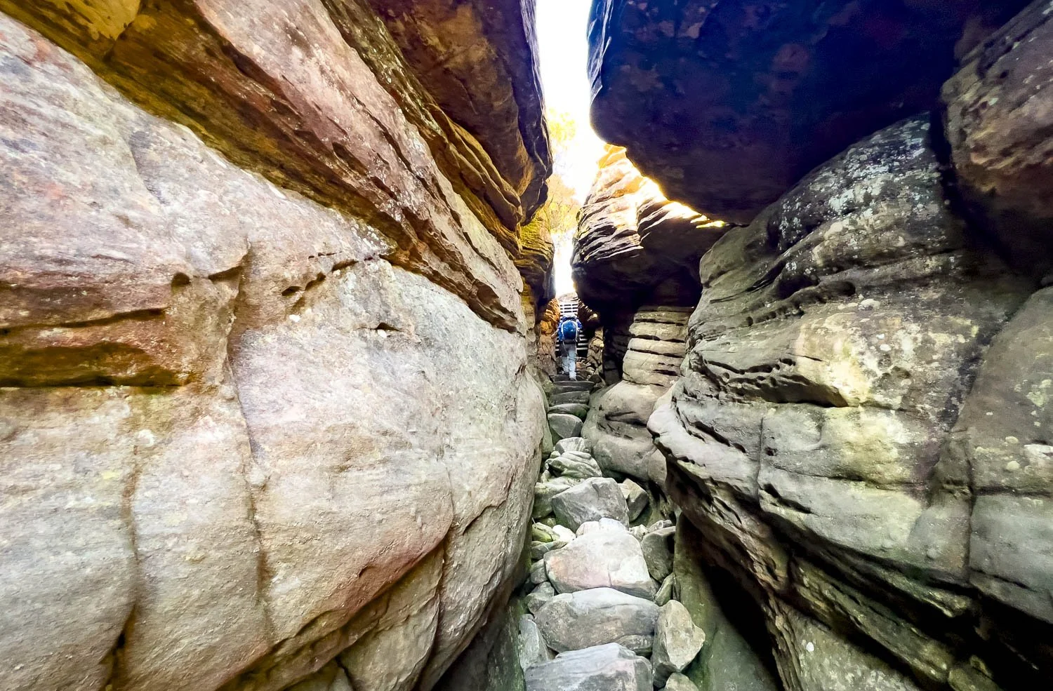
It’s already warm today, so these narrow sections between cool rock are welcome.
Silent Street is a lot of fun. Those with wide packs have a bit of a squeeze at the end. None of the walking is technically difficult, other than the relentless elevation gain.

At last you’re at the top, on the edge of the escarpment, here looking southeast towards Lake Bellfield; the lead image at the start of this article is taken from the same place but looking north. Tomorrow you’ll camp at Barri Yalug near the lake’s far southern edge, and after that the GPT follows the range behind it.
The Pinnacle itself, enclosed by cyclone fencing, is around the corner from the right top of this image. We are here around noon and a queue has formed; many people are on the lookout itself. Very few people venture anywhere else. We wait our turn and go to the tip but at busy times you will find equally good and far more serene views on the rocky edges either side.

Although they resemble crows and ravens, Pied Currawongs (Strepera graculina) are more closely related to magpies and butcherbirds. They are intelligent, bold and adaptable: this one was drinking from a small rock pool beside us whilst surreptitiously eyeing our lunch.

The moment you continue south past the Pinnacle, the Trail is suddenly, blessedly quiet: nearly all visitors are day hikers on an out and return from Wonderland Car Park.

You’ll pass the Spine, aka the Nerve Test. In the past, Darwin’s theory has unfortunately applied to those with more nerve than coordination: the drops either side are fatal. And no, lacking both necessary attributes but gifted with imagination, we didn’t.

Just look at that landscape. It’s so varied and — hooray! — no more big climbs for the day.

The weather and timing are exactly right for reptile humpy-rumpy. All the way up, we’ve seen pairs and even threesomes. With these Sleepy lizards, you’ll sometimes spot a train of them, a female in the lead and hopeful males jostling for position behind.

Skinks too: they are often so engrossed in each other that you can get much closer to them than usual. Female White’s Skink (Liopholis whitii) on the left, male on the right.

More undulating terrain with sandstone underfoot and tea tree either side.

A final descent into Bugiga. There are a few bits like this but nothing scrambly where you need your hands.

More Epacris impressa, here a lovely clear pink, elsewhere red or white.

The campground is off a short spur trail; the sign above illustrates the layout. It is a beautiful site that will become more so as groundcovers disturbed by construction regenerate.

The plate steel toilet block has been built to withstand bushfire; rainwater tanks are enclosed within, with an underground pipe leading to a tap beside the shelter. The tanks here are filled by water tanker and aren’t reliant on rainwater but, because the tap beside the shelter doesn’t have a spring switch and can be left running, the tanks can and have emptied. Hopefully Parks will replace the tap.

The somewhat industrial shelter is unique on the Trail. It resembles an aircraft hangar and, like the toilets, has been designed to survive bushfire. Clear polycarbonate roofing panels will melt but are more cheaply replaced.
Geoff is at the charging station, about to plug in his Garmin watch. He uses it to record distances, elevation and map our route for the profiles, data and maps you see at the start of each blog. He lost his first watch whilst hang gliding; this replacement is a recently superseded model. Recently superseded smartwatch models are usually heavily discounted and often functionally almost as good as newer models. Older eyes may appreciate bulkier versions with larger screens!

The platforms at Bugiga are circular and once again constructed without significant gaps between the planking: pretty but impractical. Instead of chains, wire runs along the outside of the platform. Nevertheless, the campground is beautifully placed, with the towering wall of Mt Rosea (you’ll climb it tomorrow!) to the south and views over valleys to the north. And you will likely arrive here with plenty of time to enjoy them after a fun day’s hiking!