
Dolomites Hike Planning and Tips

Mist-shrouded tors, Dolomites.
Why Hike The Dolomites?
The Dolomites in northern Italy is home to numerous world-class day, multiday and thru-hikes, with an astonishing network of well-signposted, named paths that make navigation straightforward. You could easily spend several liftetimes exploring these mountains.
The geology makes for spectacular crags and tors, mountains and unique vegetation; the Dolomites is famous for its amazing wildflowers, with about 2,300 different species, many of which flower in spring for a gobsmacking display; it’s one of our favourite places to walk. One elderly hiker we met told us that he’d climbed almost every mountain range in the world, but the Dolomites was his favourite: “In those big, vast ranges, you may be hiking for an entire day, and the view of the mountain changes only a little,” he said. “Here, you get a new view every hour.”

Villages tucked into valleys and rifugios at elevation provide numerous accommodation options for hikers.
You’ll see numerous villages in the valleys, and rifugios at elevation, with shorter distances between accommodation than for many hikes in less densely populated countries such as Australia, New Zealand and even the US: the Dolomites is perfect for us slower hikers because we will have no trouble planning hikes with shorter daily distances. Not only that but, for non-purists, there is often a cable car or chair lift to ease the elevation gain, and these are common and accepted components of many routes.

A cruisy start to a hike from Alleghe!
Accommodation

Invitingly cosy and comfortable Rifugio Tissi
The rifugios, or mountain huts, are not like those in Australia and New Zealand, but rather like tiny motels, and there are more than 1,000 of them in the Dolomites. For a fee, the hosts provide delicious hot dinners, breakfasts, and sometimes packed lunches: even on thru- hikes, you’ll have no trouble maintaining your weight! You’ll usually sleep in bunk beds and/or in small dorms; a few have private rooms. They provide blankets but not always sheets or pillowcases, so carry a YHA or travel sleeping bag liner.
Rifugios are not cheap because transporting food to them is expensive, but you can save by joining the Italian Alpine Club if you expect to stay in a handful or more rifugios on your trip. This excellent website tells you everything you need to know about booking and staying in rifugios.
If you’re carrying a tent, sleeping gear and kitchen, you have a great deal of flexibility. Wild camping is illegal in most of the Dolomites as so much comprises National Park, but many rifugios have adjacent areas with room for one or two tents should the hut be full or your budget small; for a more modest fee you can still use their facilities and eat their delicious meals.
However, camping is defined as staying 48 hours in one spot and some hikers set up after sunset and leave before sunrise the following morning in an overnight bivouac, especially when hiking longer routes such as the Alta Via. This appears to be tolerated but it’s essential you strictly follow LNT principles: no one should be able to see you’ve camped there.

Typical rifugio accommodation

My breakfast cuppa with dunking bickies and Geoff’s ristretto - yum!
In the off-season in little villages (as opposed to larger tourist magnets), there are more places to stay. Some have small campgrounds, or you can choose B&B’s or hotels with a $0 cancellation policy. This is important when planning hikes in alpine areas because, if the weather changes, you may be restricted to the valleys, instead of staying overnight in the higher-altitude rifugios, or you may need to delay or extend your schedule as we did on the Civetta hike. Even with a $0 cancellation policy, it’s polite to discuss your weather-dependent hiking plans with the manager beforehand or upon arrival.
Transport
Transport between towns, including the smallest of villages, is well served by the Dolomiti Bus company. There is such a fantastic network of hiking paths that, if you are carrying typical self-sufficient hiker gear, you can hop on a bus in a village at the end of one track and catch it (and/or several others) to the next place you want to explore. One thing to remember is that gauging travel time by distances between towns as the crow flies, or even road distances, is deceptively unreliable. The roads are narrow, circuitous and winding, so you may need large detours around mountains between seemingly nearby adjacent towns. Check timetables - and topography! - carefully!
When to Hike

Still plenty of snow this year in mid-July at Tre Cime
You’ll need transport and open rifugios, so the hiking season is usually mid-June to late September. However, bear in mind that a late season may mean that some rifugios and hikes may be closed or inaccessible due to snow, as we experienced one year in early July. Mid August is peak holiday season when everything will be trickier to book.
Wildflower enthusiasts should choose mid-July for the incredibly spectacular displays. Numerous wildflower tours are available but, if you are a hiker, you will not need one. Simply by traversing many kilometres through valleys and into higher elevations, you’ll pass through forest, sub alpine and alpine environments, with microclimates of scree, rock, marsh and more, with flowers growing right beside the path, and dozens of different species in just a few square metres of the acres of alpine meadow you’ll cross.

Alpine meadows filled with spring flowers

Edelweiss!
Maps, Trail Guides and Planning
Travel Guides vary in quality, but Gillian Price’s Cicerone Guides are some of the best we have seen. Her Dolomites books cover Day Walks, Multi Day Treks, as well as two thru-hikes, the Alta Vie 1 and Alta Vie 2. The books are accurate, readable and provide a real sense of the ambience of the hikes so you can choose those that suit your preferences.
Reading the guides is a great starting place for planning your trip, but you should team them with the relevant Tabacco Maps. These large scale maps are invaluable in planning eg for linking hikes, routing around sections you consider too demanding (eg Via ferratas) or for flexibility in planning alternate routes and bailouts in the case of poor weather.
And it’s worth noting that the trails, whilst normally well marked and trodden, often have significant elevation gains. Sections may be steep and rocky, so trails are usually more demanding than distances alone suggest: we recommend that leisurely hikers are conservative in their daily planning.
Civetta Hike

Torre Trieste with expansive views beyond
The spectacular, world class hike along and/or around Monte Civetta was our favourite in the Dolomites… so much so that we returned two years later for the part we weren’t able to complete the first time. The views are magnificent and the variety astonishing. You experience expansive views, spectacular crags, alpine meadows, high passes, a stunning cirque, scree and numerous wildflowers. The more adventurous can climb Civetta’s peak using via ferratas, but this was above our skill level: the options described here are true hikes rather than scrambles.
There are numerous ways to hike around Monte Civetta, including several day hike options. But the day hike options are long (typically 15 to 20km) and include elevation gains over 1600 m.
But we are leisurely hikers here, aren’t we? So we strongly recommend that you spend at least two days doing this hike, even budgeting an extra in case of bad weather if you plan to cross the Forcella della Sasse, which we also highly recommend for its superb views.
Slower Hiking Option 1: Pecol [or Alleghe], Lake Coldai, Rif Tissi, Rif Vazzoler, Forcella della Sasse, Pecol - a Loop Hike
This our recommended option in good weather and conditions. You can start from Mareson-Pecol or from Alleghe (as we did on our first hike – see Option 2). It involves walking around the flanks of Civetta with extraordinary views every step of the way.

Here are the elevation details for the full loop, nearly 2600 metres (8510 feet) gain and loss over 29.5 kilometres (18.3 miles)
If starting in Pecol, simply follow 556 northwest to Rif. Coldai. If starting in Alleghe, take the cable car and/or chair lift to route 554 (purists can walk 564 from town), turning south onto 556 to Rif. Coldai.

Resting enroute to Rif Coldai, looking back to where track 564 meets 556.
Past Rif. Coldai veer right onto 560 to skirt the lake and traverse Civetta’s spectacular northwestern face. However, when you reach the Rifugia Tissi spur trail, divert to stay overnight. There is a magnificent view down into Alleghe behind the hut, and of course the views of Civetta’s face are second to none.

View to Alleghe from the lookout at Rifugia Tissi
The next day, continue south to Rif. Vazzoler, then east and north along 558 past Torre Trieste, around Civetta’s southern and southeastern heights, through the Val della Sasse before crossing the high pass. People completing the circuit back to Rif Coldai continue all the way along Civetta’s eastern face on 557 with some exposed scrambling and a short section of Via ferrata, but we will divert east onto 587 to complete the loop and return Mareson-Pecol.
This route could certainly be done in two very long days, but the high pass after Rif Vazzoler should not be crossed in bad weather, which often occurs in the afternoon as clouds build. In this case, it’s better for leisurely hikers to stop short at Rif. Vazzoler, spending time in the botanic garden, before crossing the pass the next morning in fine conditions. Nor is it advisable for hikers inexperienced in alpine conditions when there is a lot of snow still about.
The route could be shortened by skipping Rif. Tissi and going directly to the Rif Vazzoler from Lake Coldai. But as you can see, the views from, and ambience of, Rif. Tissi are wonderful and worth a stop. The 250 metre spur track to Rif Tissi is steep and rough, so pushing on to the Rif Vazzoler on day 1 from Rif Tissi is not a very leisurely hiking option.
Slower Hiking Option 2: Alleghe, Lake Coldai, Rif Tissi, Listolade
If the summer season and snow melt are late, snow remaining at elevation will limit options for hikers without mountaineering experience like Geoff and me, so we did this two day hike instead. When planning ahead, always consider alternative routes and bailouts.

The lower flanks of Civetta are manageable for folk with little snow experience like us, but we weren’t prepared to cross the high steep pass this particular year.
The schedules from Pecol or Alleghe for this shorter option are the same up to Rif. Tissi. The next day, however, you will head to Rif. Vazzoler, explore the Botanic Garden and then, instead of continuing up 558 to the pass, you’ll descend to Listolade via 555, where you can catch a bus back to Alleghe – it’s a pleasant 30-minute ride - or go elsewhere. However, check bus timetables carefully before you leave because services vary throughout the week and month.
Alternatively, stay at Rif. Capanna Trieste a short distance before Listolade, if you think you won’t make it to the bus in time.
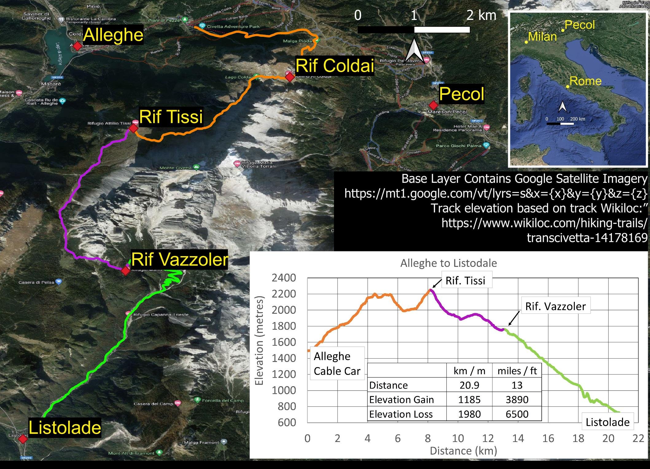
This alternate route is very doable at a leisurely pace over two days if weather or time limit your options.
The Pelmo Circuit
Monte Pelmo is east of Civetta, separated from it by flower-filled meadows dotted with convenient rifugios. A wonderful overnight (for slower hikers!) circuit runs around the mountain, starting on the western side at Rif. Staulanza and ascending to Pelmo’s upper tors to cross a pass, then descending to Rif. Venezia on the east. You return along the southern flanks to Rif. Staulanza, or branching off earlier along 474 to Rif. Coldai if combining this hike with Civetta. Although the two walks are adjacent, they are very different in character, with Pelmo boasting vast scree slopes, expansive views and even dinosaur footprints!

Because the walks are so close together, it is easy to link them and we highly recommend that you do so if in the region.
Combining the Civetta and Pelmo Hikes
You have numerous ways to combine this hike with the Civetta circuit, but we suggest you do Pelmo first.
Slower hikers will start from Pecol (or Alleghe) to reach Rif. Staulanza, before continuing to Rif. Venezia on the second day. On the third day, slower hikers either complete the full citrcuit to Staulanza and hike back down the 251 road to Rifs. Monte Pelmo and Pala Favera, or branch off (make sure you see the dinosaur footprints, then backtrack a little) to take Path 474 to Rifs. Monte Pelmo and Pala Favera, then Path 564 to Rif Coldai. The elevation gains and grades this day are the easiest so you should be able to reach Rif Coldai but if not, schedule a stop at the intermediate Rifugios.
From Rif Coldai you continue along the Civetta loop to Rif. Vazzoler but we highly recommend that you take the spur track to Rif Tissi for lunch to soak in the amazing views down to Alleghe and also of the Civetta face itself. That will add an extra km but worth the effort as you should have plenty of time.
If you start your walk from Alleghe you catch the funicular and ski lift; and then return via Listolade as per the Civetta Hike Option.
If you start from Pecol its a short walk up alongside the road until Rif Monte Pelmo where you branch off, or you catch a Dolomites bus to Rif Staulanza.
Here’s a map of the route options with distances.

Refer to the individual hike pages for guidance on the daily elevation details. When the tracks are combined, the Alleghe option involves a not inconsiderable total elevation gain of 2,250m (7,400 ft), the Pecol option 3,650m (12,000ft).