
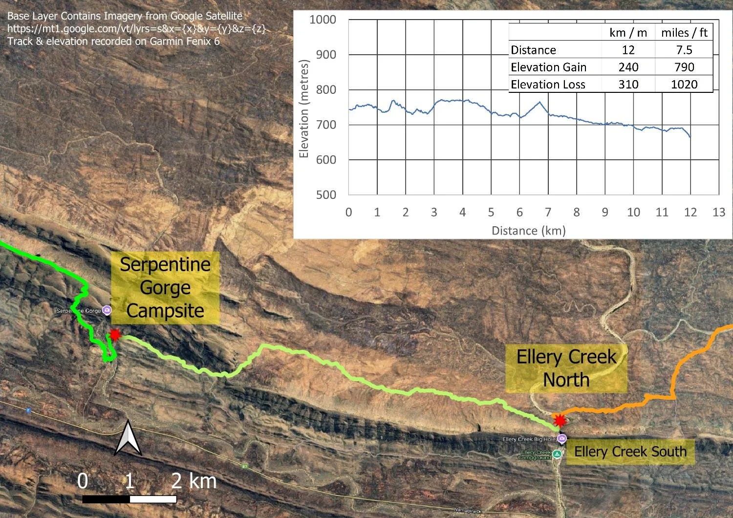
Serpentine Gorge to Ellery Creek North (Day 10, Sect. 7)
A wide, hot plain and a deep, cool waterhole

Today you enter the Alice Valley on the northern side of the Heavitree Range, here looking back at Serpentine Gorge from the north.

With the exception of the Ormiston Pound Day Walk, this will be the first time Larapinta hikers cross to the northern side of the Heavitree Range, with grand views of the Chewings Range to which you will cross in a day or two’s time.
Today’s hike
From Serpentine Gorge camp it’s just a couple of kilometres through rolling foothills to the junction branching north through a fun rocky gap to Ellery Creek North, or straight ahead to Ellery Creek South (see Planning and Tips and Itinerary for why we strongly recommend Ellery Creek North).
When you emerge from the gap, views immediately widen marvellously. Some hikers told us this was their least favourite part of the track, but we loved it. The track parallels the northerly face of the Heavitree Range, through the Alice Valley — really a wide plain — with grand views, and a tiny hillock to climb. You’ll see your destination as a break in the range for many kilometres, and feel small in the vast landscape.
The hut is some distance out from the gorge with campsites on the open plain around it, but many hikers prefer to camp under the trees on the sheltered sandy banks closer in.
If you’re following our itinerary, compare your times to ours each day or check the table in Itinerary. Or, check your times against the ones in your Park Maps. That way, when you reach the most challenging sections around Standley Chasm, you’ll know whether you will be faster or slower than us or official figures on those days, and whether you need to allow more time. We took 6 hours to get to Ellery Creek North.
How to Make Today Easier
For the first time thus far on your W2E journey, the track map is especially deceptive. A glance at the wide Alice Valley, the apparent lack of elevation gain and loss, those widely spaced lines on the topographic map, make less experienced hikers — or even experienced hikers unfamiliar with the terrain and the term ‘Larapinta flat’ — think that they’ll easily reach Rocky Gully (25.6km/15.9mi), Ghost Gum Flat (34km/21.1mi) or even Hugh Gorge (40.9km/25.4mi). And then of course there is the weather - even when we hiked it was hotter than we’d prefer with virtually no shade along the way. This track demands respect and, as long as you do, it is very enjoyable.
We met a number of E2W hikers on this section and during our Rest Day at Ellery Creek North who were all sweating to reach Serpentine Gorge campsite. On that rest day, we saw many hikers who didn’t even divert the 100m/328ft or so to look at Ellery Creek’s beautiful waterhole, such was the time pressure they were under. Several expressed regret that they couldn’t stop at Ellery Creek North.
Although you are hiking along the Alice Valley, the terrain is undulating and you have almost continuous small rises and dips, often too small to register on your Garmin… but definitely registered by your legs!
In addition, there is virtually no shade; remember that forecast temperatures are measured in shade. Although air temperatures are the same in shade, direct solar radiation makes us feel 10-15C (50-59F) hotter, so hiking in 29C/84F can easily feel like hiking in 40-44C/104-111F — temperatures we can all agree are uncomfortable.
This is why slower hikers should definitely stop at Ellery Creek North. However, if you’re faster and reach it mid-morning with plenty of gas left in the tank, by all means keep going after collecting water at the hut, remembering that the terrain becomes hillier further east. However, plan to stop here rather than at Rocky Gully, because this maximises your flexibility without imposing undue pressure, especially in hot weather. A conservative itinerary might mean you finish earlier than planned, but being ahead of schedule is not a problem when you can book or change accommodation later when you near Alice Springs.
Starting early helps you beat the hottest part of the day.
Walk with Us

Heading towards the gap early morning in delightful cool shade. The track through rolling foothills is easy underfoot.

Beautiful spinifex in mallee woodland.

I think this is some form of limestone.

Flat-leafed Mistletoe, Lysiana spathulata

Nearing the gap. Soon you will be through and onto the northern side of the range.

Pineapple Indigo (Indigofera amoena) and Wickham’s Grevillea (G. wickhamii) make a sensational splash of colour in the gorge.
E2W hikers who have their food drop in Ellery Creek South are locked into that site because it is many kilometres of backtracking to get to Ellery Creek North. Any hiker in either direction wanting to stay at Ellery Creek North should drop their food at Serpentine Gorge.

The gap gradually becomes rockier…

… with a little easy scrambling over a few boulders around tiny rock pools.

Over the hump.
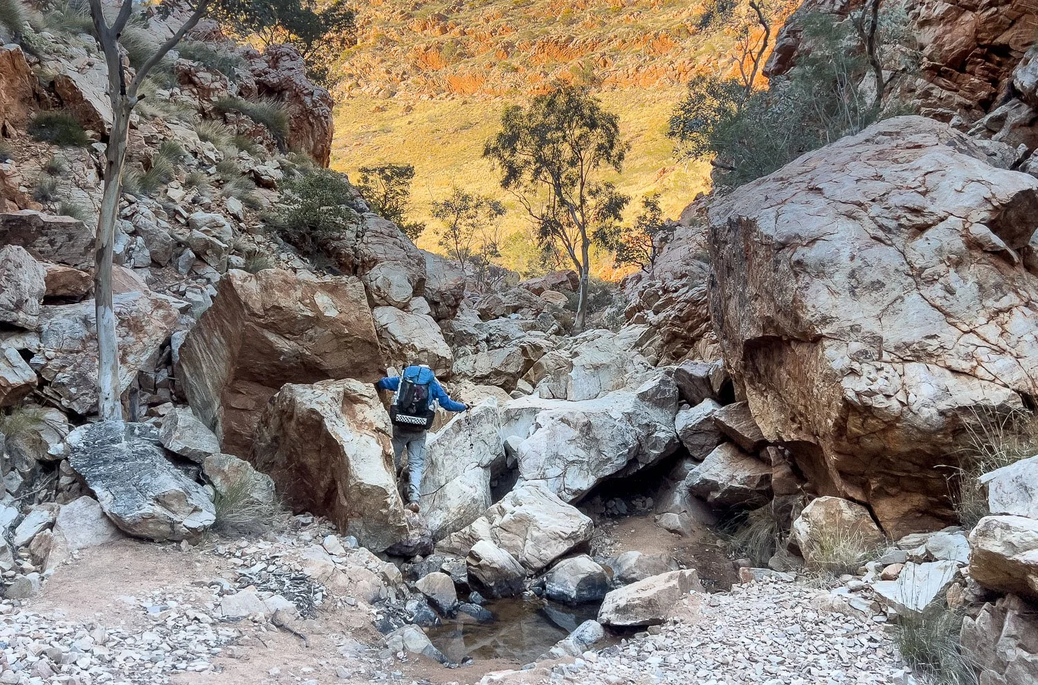
This wide image gives you a clearer idea of the rocks and scrambling. It’s only a short distance — perhaps fifty metres — and even in this picture you can see the other side.

Looking back into the gap from the northern side. The track is much easier now!

The views become increasingly expansive. Here, multiple little gullies and rises of the valley: it’s definitely not flat all the way!

The Heavitree Range stretches into the distance, a grand sight.

After good seasonal conditions, botanists will find a happy variety of interesting and quite different small flowering forbs like this Blue Goodenia (G. azurea) in the valley, as well as a healthy and diverse range of grasses.

The gap through which Ellery Creek passes is visible from many kilometres away (centre of picture)

Up a small hillock: why doesn’t the track avoid it?

On reaching the top the views are grand…

…and worth a pause to absorb them.

Lunch stop in a tiny patch of shade just off the track, umbrella balanced on branches for a little extra protection.

Then on again towards the gap in Heavitree Range.

Nearly there!

First views of Ellery Creek

After checking the sites around the hut, we return to the creek and pitch on its sandy banks.
Our down sleeping twin quilt is airing on a limb far left. It’s hydrophobic down so takes a long time to get damp, but nights have been cold and, over time, moisture builds up. Airing in the sun like this quickly revives loft.
We find a twin quilt by far the most comfortable lightweight sleep system we’ve ever used on trail as a couple. Teamed with mats strapped together and individual silk inner bags, we can spoon or sleep back to back or side by side. But you do need to be comfortable actually sleeping (not just canoodling, anyone can do that!) as a couple in such close proximity! Couples and solo hikers interested in going lighter, see our article about a lightweight sleep system.

The hut is further out on the plain.

The campsites around the plain are quite exposed, but it’s likely that the campsites in the gap will be less protected than you might expect because wind accelerates as it venturis through. In strong southerlies, the hut is likely the most sheltered spot.

And of course make time to visit the beautiful waterhole for a refreshing dip to cool down.

A magnificent sunset… another one.
We respectfully acknowledge the Arrernte People as the traditional custodians of the land on which we walk and pay our respects to Elders past and present and to the Aboriginal people present today.