
Day 6: Turua Beach to Osmiridium Beach
Deserted beaches, mountain views and a fun estuary crossing

A fun estuary crossing.
Today’s 12.6km (7.8mi) hike has all the wonderful variety of previous days, with a fun boat crossing thrown in. At the end of Turua Beach you climb over a headland past Menzies Bluff and descend steeply to the narrow gorge at the western end of Prion Beach where you’ll cross Grotto Creek. Then it's 4km (2.5mi) of sand, a row across New Lagoon and a climb over another headland with more creek crossings before your final descent to Osmiridium Beach. The views are marvellous, with the spectacular face of Precipitous Bluff dominating the skyline, and grand vistas westwards from all the high points.

Two main climbs (with smaller ups and downs) for the day, with the beach in between.
How to Make Today Easier
Today’s hike of 12.6km (7.8mi) is perfectly manageable, and most slower hikers should have no trouble completing the day if you don’t have to wait for low tides at Grotto Creek, or strong winds at the estuary. Check tide times and plan accordingly.
The sea can be powerful at Grotto Creek, and hikers have been held up there (as well as at the New Lagoon crossing). We timed our run between waves to avoid getting our feet wet but, in wild weather, this spot could be dangerous with deep, turbulent water and submerged rocks. Check and print out tide times and plan accordingly; in stormy weather with southerlies, consider waiting. If it’s that wild, you probably can’t cross the estuary anyway. Collect water at Grotto Creek before traversing Prion Beach; water at both Prion and Osmiridium are unreliable.
The skiff is flat-bottomed and stable, but this also makes it highly susceptible to weathercocking as well as drifting sideways, especially with inexperienced rowers. Check the forecast and time your crossing for when winds are light; wind always varies but upper level currents usually reach ground level around 11am so conditions are often best early. Afternoon seabreezes can get strong too.
We crossed the 200m (220yd) distance in a light breeze, and even then one of us was rowing mightily to keep the skiff travelling straight. Remember, you have three trips: one to reach the second boat on the eastern shore, one to tow the second boat back to the western shore, and a third trip to get yourself across, thereby leaving a boat on each bank. If you think you won’t be able to make three trips due to conditions, do not cross at all (unless in the happy coincidence of another hiker crossing from the opposite shore). If you leave one bank without a boat, you are stranding all the hikers on that side.
If delayed, you can stop at Prion Campsite once you cross, but this will change your itinerary from our recommendations. However, it’s essential to stay flexible: never stick to a plan when conditions dictate otherwise, for example strong winds at the estuary. You may need to add an extra day here, and hike a longer distance tomorrow, or skip our rest day at Granite Beach.
Walk with Us:
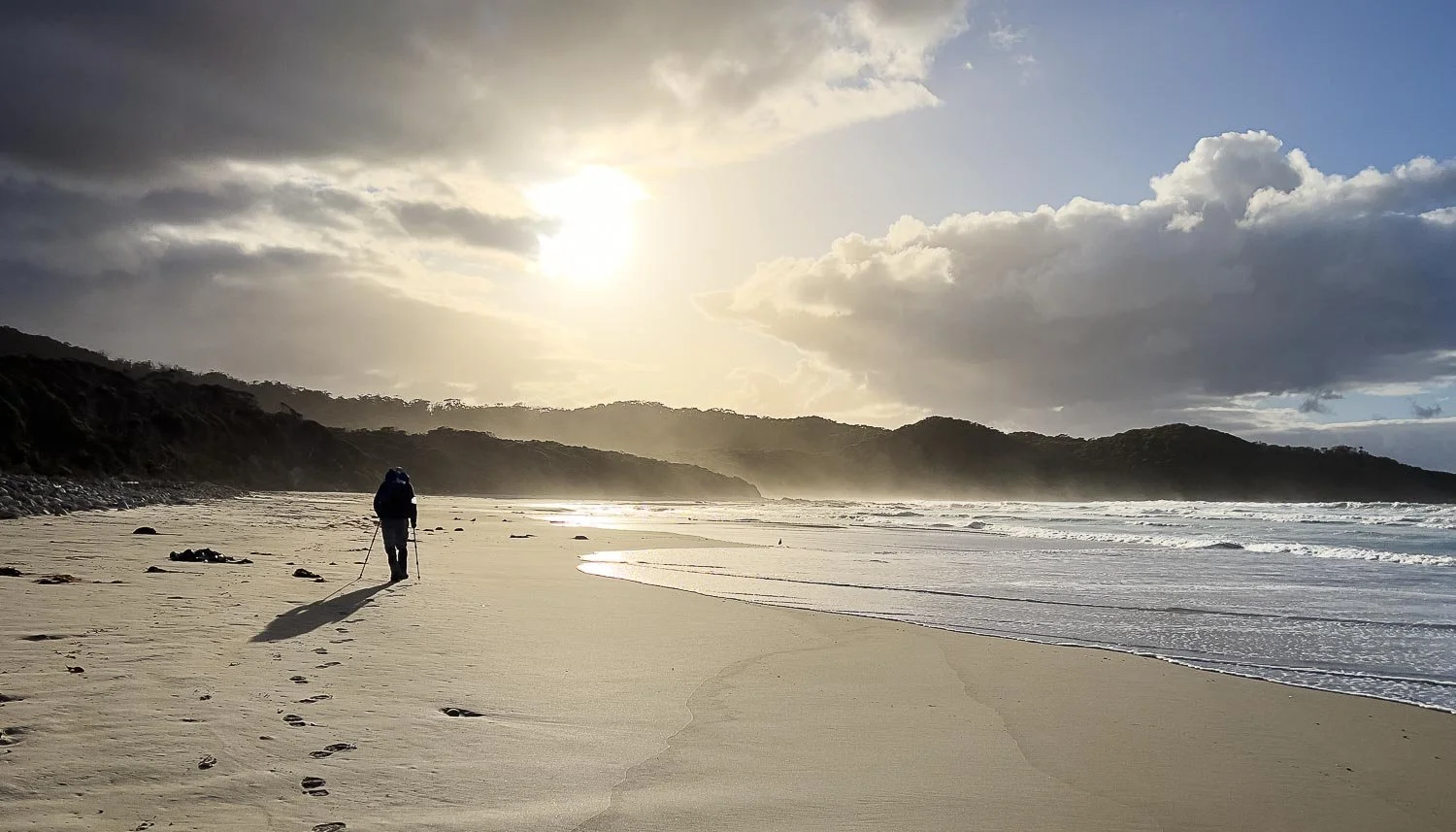
An early start into the soft morning light ensures leisurely hikers reach the estuary crossing at a good hour.

Beautifully textured and coloured rock near the end of Turua Beach.

Into open forest to cross the headland.

Ferns provide a glorious mix of textures, here Pouched Coral Fern (Gleichenia dicarpa).

Plenty of thick and overgrown sections are dry now, but you can imagine how wet you would get with poor rainwear.
From Menzies Bluff you have views that stretch westward with Purrar Point, followed by Havelock Bluff and the Ironbounds, with Cox Bluff and Telopea Point in the distance. You have walked almost the entire way!

The forest is delightful and the weather, well, only a little drizzle a few times on the hike thus far. A Bassian Thrush flits ahead on the track, never quite close enough to photograph.

After a very steep descent into Grotto Creek, Geoff climbs a short distance upstream to collect fresh water.

Although many people use water bladders, we prefer BHP-free "smart" water bottles of the type found in every Australian supermarket. Here, a 1L and 1.5L easily fit in one side pocket of Geoff's ArcHaul 70L. We have used such bottles exclusively for many years and none have ever broken. They are a fraction of the weight of most bladders.
Place the heaviest bottle closest to your back and drink first from the one furthest from your back for optimal pack balance.
There is no reliable quality water at Prion Beach, and the water at Osmiridium Beach (Tyler Creek) is also unreliable. Collecting water a Grotto Creek is your best option. it also provides you with maximum flexibility should you get held up at the New Lagoon crossing.

After dodging the waves at Grotto Creek, you're onto Prion beach, four marvellous kilometres of sand, sea and sky. You can see the vegetation is much lower on this dune, and the face is sandy rather than rocky: much more prone to erosion. We saw no established campsites along here though we may have missed them, and John Chapman mentions none in his guidebook. Please don't make new campsites in the dunes or anywhere else on the track.

A jellyfish, possibly a Moon Jelly.

Once you near the end of the beach, watch for more flotsam markers: you'll head inland 120m (130yd) along the western side of the lagoon and over the dune to the boat mooring.

Self explanatory, but check oar lengths as there are long and short ones. Two long ones are not suited to two inexperienced rowers sitting side by side. We crossed together with our light packs each time rather than leaving them on the opposite shore, unwilling to be separated from them. The skiffs are meant for one but, by this stage of the trip with half our food eaten, we figured our combined weight would be well within the boat's capacity.
We crossed with perhaps 10-13 knots of offshore breeze only in the centre of the estuary and would not have wanted it much stronger: we maintained our heading, but only just.
Geoff and I own a kayak and sit-on-top so have paddling experience, but aren't skilled rowers. If you've never rowed or paddled before, choose lighter winds.
The current was also moderate when we paddled across but would be much faster in the narrower section closer to the sea should you be blown there.
Paddles are stored beside the box containing the PFDs.

Warnings.

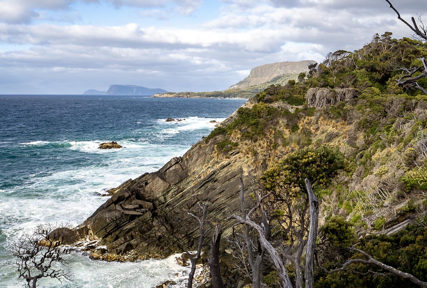
Looking across New Lagoon to the eastern shore, with Precipitous Bluff in cloud behind.

Halfway across, facing west. One pack is in the front of the boat to reduce windage. Boots are tied to our packs and our waterproof dcf packliners are tightly rolled and clipped inside.

The skiff is quite heavy! If you are pushed downwind, simply wade towards the mooring when you reach the opposite shore, towing the skiff.

It's also essential to drag the boats all the way up the sand and attach them securely to their moorings, or high flows will carry them away.
From here, experienced hikers can take a difficult 2-3 day side trip to climb Precipitous Bluff, but that's not for us today. Instead, we dry our feet and head back into the forest.

Almost immediately you reach Prion Camp, a maze of good camp sites scattered over a large area.
We have lunch here and decide to keep going towards Osmirdium Beach. If you elected to camp here then your next day would most likely be to Granite Beach (12.1km/7.5mi), or you could stop short at the lovely Surprise Bay (9km/5.6mi), then have a short 3.1km (1.9mi) day into Granite Beach rather than having a complete rest day at Granite Beach. Never feel you are locked into a single itinerary.

When you reach Wierah Hill headland, look behind you often for marvellous views over the beach and estuary.

Coastal Pinkberry, Leptecophylla oxycedrus

Milford Creek but look, Happy Days! A bridge!
The bridge is about 2km/1.3mi on from Prion Camp and the walking is easy - this section used to be fairly tough, pushing through vegetation or wading along the side of the lagoon, but we suspect the track was improved with building the bridge. However, the 700m section after the bridge, along the side of the lagoon before turning inland, is surprisingly demanding with a lot of steep, loose sand, and the track heavily overgrown with coastal wattle to duck under/push through. Fortunately, the sunshine and cooling breezes are welcome.
A couple of small but good campsites are on the western bank near the bridge so you could stop there if you are very tired. That makes Granite Beach a little easier the next day(10km/6.2mi) if that is your objective. And you could stop at Osmiridium Beach for lunch!
In benign conditions like we have experienced on this hike, the SCT is not especially difficult, but all that changes when the weather is bad. Deep creek crossings with strong currents, high seas, and exposed hillsides where the wind literally blows you off your feet wind make for a completely different experience. It’s then that you may need to change your planning as suggested above.

More duckboard through rushes. That pink blob on Geoff's pack is his towel drying in the sun. Small microfibre towels are light and absorbent, dry fast and wring out well when drenched.

Southern Leek Orchid (Prasophyllum australe)

Once you emerge into coastal heath, views open up again. It is beaut walking.

The views east are equally good, the track is gentle, the weather great. A banner day.

Tasmanian Christmas Bell (Blandfordia punicea)

Unseasonable Pink Fingers (Caladenia carnea) under the melaleucas around camp.
We take the well-marked junction to Osmiridium Beach. You’ll pass through a very swampy, boggy section with a maze of tracks where hikers have tried to avoid the wet, but where you need to head is clear.

Drop off your gear in camp and follow the creek 120m (130yd) to the beach.

Geologists will love Osmiridium Beach with its spectacular headland of folded, swirling rock. Geoff is sitting at its foot.
Osmiridium is a rare "natural alloy(s) of the elements osmium and iridium, with traces of other platinum-group metals". (Wikipedia). It's apparently one of the heaviest metals and presumably is to be found in the rock formations here, but we have no idea what to look for: both Geoff and I have long forgotten our Geology from Uni. Geologist reader input welcome!

A closeup of the rock in green, orange and red: through the lens it is reminiscent of a satellite image of arid landforms.

And then back to our pleasant campsite amongst the trees. Is this our favourite day? Maybe, but they have all been great!
We acknowledge the Tasmanian Aboriginal people and their enduring custodianship of lutruwita (Tasmania).