
Grampians Peaks Trail Guide and Planning
We respectfully acknowledge the Djab Wurrung and Jardwardjali people as the traditional custodians of the lands and waters of Gariwerd.
Endless exhilarating views, fun and challenging hiking, exceptional wildlife and a blaze of spring wildflowers: the extraordinary Grampians Peaks Trail is the newest iconic Australian walk.

Why Hike the Grampians Peaks Trail
The Grampians/Gariwerd National Park is a 1,700 sqkm (652 sqmi) reserve in Australia’s central-western Victoria. Set amongst plains of farmland studded with shining lakes, Gariwerd comprises a series of north-south ranges with peaks that jut spectacularly 1000 metres above the surrounding landscape. These ranges boast vertiginous cliffs and imposing crags, sweeping slopes and high plateaus, deep shady gullies and rushing waterfalls… and you’ll experience all of them on the walk.

Waterfalls in winter and after rain

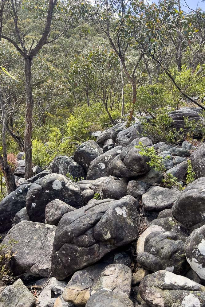
Amazing rock formations
Because the trail largely follows the backbones of these ranges, jumping between them now and then, you not only enjoy the unique landforms but also vast views to the east and west, sometimes simultaneously. When you reach the highest points, the ranges stretch ahead and behind you. Of all the walks Geoff and I have done in Australia, this one has the most consistent vistas, not just when you reach a peak but along much of the Trail.
Geologists will be thrilled by the story written in folded and twisted sedimentary sandstones, siltstones and mudstones, weathered granitic igneous intrusions, fault lines and numerous other rock formations.

Because such varied geology and topography provide so many different environmental niches, wildlife and wildflower diversity are equally extraordinary. The Grampians boasts an astonishing seven different vegetation types and is host to almost 1,000 vascular plants, more than one third of all the plants in Victoria; many of them are found nowhere but in the park. The spring wildflower display here is as famous as those in Western Australia.

Orchid enthusiasts are in for a treat as well: here, Pterostylis macilenta. Make time to explore surrounding reserves while you’re in the region.

White Spider Orchid (Caladenia venusta)
Wildlife is prolific too. You’ll be woken by kookaburras laughing and gang-gang cockatoos creaking open doors each morning. In Halls Gap, kangaroos and wallabies hop around town — the paddocks look as if farmers are raising them! — while cheeky rosellas and sulphur-crested cockatoos snatch snacks from your hand when you’re not watching: overseas hikers are in for a real treat. But alas there are no wombats… read our daily blogs and you’ll soon understand why!

View from our motel in the heart of Hall’s Gap

Cheeky sulphur-crested cockatoo.
The hike finishes in Dunkeld, a beaut little country town that offers a less touristy version of Australia than many places nearby. And of course this incredible environment has supported First Nations people for at least twenty thousand years; the Brambuk Cultural Centre is closed at time of writing but the Information Centre is open.

Someone walking down a Dunkeld side street with a pet or Judas sheep. Supermarket far right.
Although the GPT is new — it was officially opened in November 2021 — it is so wonderfully unique that we have no doubt that it will soon join the ranks of other iconic Australian Great Walks like the Cape to Cape and the Overland. It is certainly equal to both.
Hike Overview
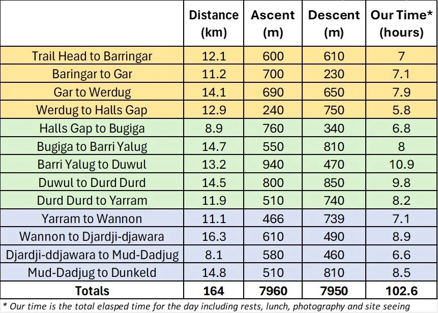
The 164km Grampians Peaks Trail is bi-directional but was designed to be hiked north to south. It is arranged into northern, central and southern sections. The northern section (4 days, 51km/32mi) starts at the Mt Zero Trailhead and finishes at the township of Halls Gap. The Central section (5 days, 64km/39mi) starts at Halls Gap and finishes at Yarram campground. And the Southern Section (4 days, 49km 31mi) starts at Yarram campground and finishes at Dunkeld township.
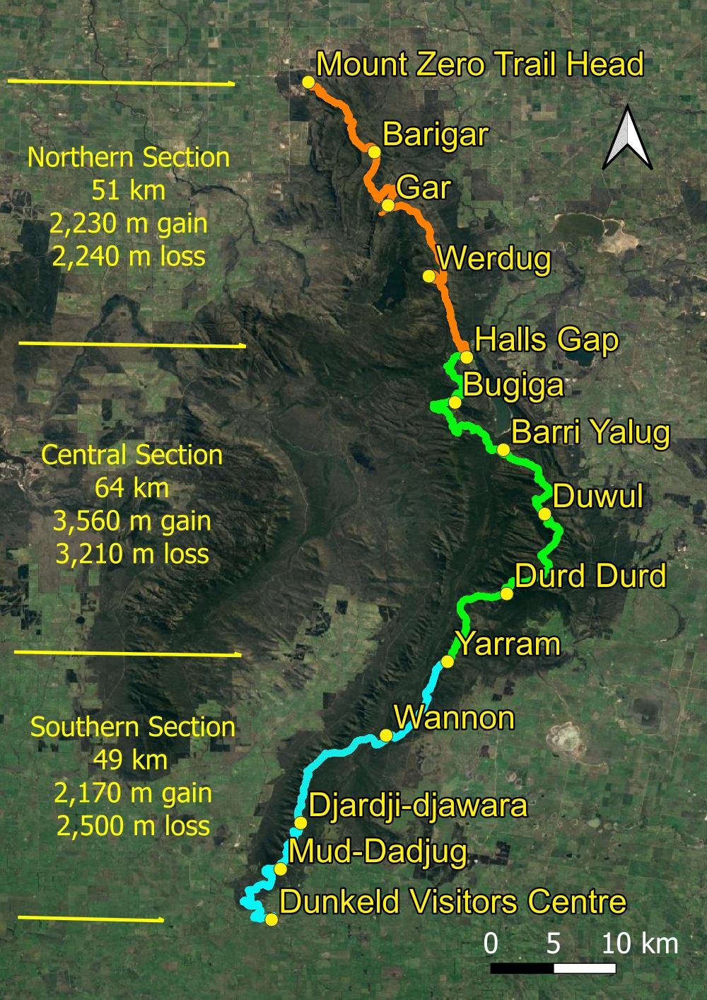
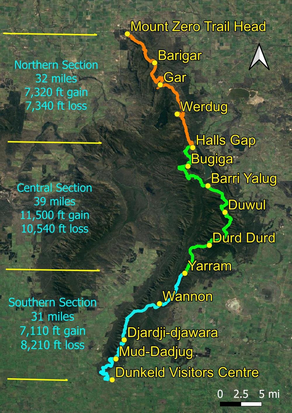
Click image to toggle between metric and imperial measurements.

End to end section statistics Grampians Peaks Trail
Much of the Trail is itself an incredible feat of engineering. It took two decades to complete; the northern section was built without large machinery so as to preserve the environment, and countless steps were constructed with old-school crowbar, block and tackle.

Beautifully constructed rustic steps. We generally prefer more natural tracks but boy, were we grateful for these!
The central section links existing tracks and is infamously described as ‘the bit where the money ran out’; this may be true as Parks usually have money for new trails but little for maintaining existing ones. The southern section traverses entirely new ground along the Serra Range before joining and linking upgraded existing tracks.
Grading

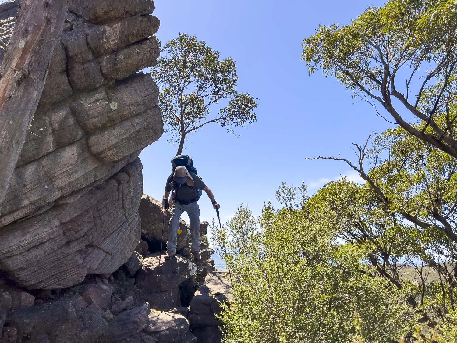
The trail is fabulously fun and varied. There are steps and rock overhangs to scramble up and under and through, bridges and stepping stones, steel mesh walkways, boulder-hopping and easy scrambling but don’t be misled: much of this Trail, especially the central section, is Grade 4 and 5. Though some parts are sandy and easy, most of the track is rough and uneven underfoot and, for slower hikers, you will be walking for much of the day despite the seemingly short distances. There is no real exposure to steep dropoffs but the track still passes close by to offer those amazing views.

Lunch with a view. Another one!
A number of rangers and tour guides told us that many hikers underestimate the track’s difficulty. Rather than daunting slower hikers, the following description aims to foster realistic expectations and appropriate planning to complete your hike successfully and enjoyably.
A total elevation gain of around 8,000m (26,000ft) is nothing to be sneezed at: you will almost climb Mt Everest; in these 164 km there is more ascent and descent than on nearly all comparable mainland Australian hikes. Averaged out, the grade when you’re gaining elevation is 9.6%. Compare that to the Australian Alps Walking Track’s 8.2%, The Overland Track’s 7%, Larapinta’s 6.4% and Bibbulmun’s 4.5%. The stone steps are beautifully rustic but uneven in height; in the central and southern sections the trail often comprises scree or boulders. You’ll regularly traverse long sloping rock slabs that become extremely slippery after prolonged rain. The continuous 550m (1800ft) descent into Halls Gap murders creaky knees. We found this hike significantly more challenging than the Cape to Cape, Overland Track, Larapinta and even the South Coast Track. Make no mistake: this track is demanding.
Elevation profile, Grampians Peaks Trail

We met a significant number of younger solo hikers who were alone because their hiking companion(s) had bailed in the central section. We read about a group of a dozen where half bailed through exhaustion and injury. We met a group of four young twenty-somethings running the track in preparation for the 100-miler event; when we saw them later two had pulled out due to injury. We know a group of Queenslanders who bailed due to inclement weather and inappropriate clothing. Older hikers will greatly benefit from correctly-used trekking poles; we are all too aware of what injuries mean and tend to take it more carefully. For this reason, we are likely to be especially slow on this track.
The Tour Mt Blanc is a comparable distance (170km) with more elevation gain (10,000m), but the tracks there are smooth and well trodden. We found the GPT more difficult. Here are some pictures of tricky bits of trail to give you an idea of what to expect:

Plenty of fun scrambly bits…

More scrambles
This looks exposed but it is never climbing and there is more room between you and the edge than it appears.
Sometimes the track is identifiable only because no bushes are growing on that part of the hill!

More ‘track’. Young folk will skip across these, but older folk are likely to be slower both going up and going down.
Our daily descriptions include many more images of the track itself, especially the more challenging bits, to help you decide whether this trail is for you and to help you customise your itinerary for a fun hike. Links to each section follow, with daily blogs within each (Button links to each section are also provided at the end of this blog).
But also remember that there is easier trail between the tricky bits, and slower hikers like us can start early and take it carefully. Even a very slow hiker like me was able to successfully complete the entire trail using the standard itinerary but with a longer break in Halls Gap. Most reasonably fit people, old or young, should have no problem with the northern section but, if you find it near your limit, the central and possibly the southern sections are likely to be too difficult. Having said all that, some young fast hikers were double-hutting them, although this is unlikely to be relevant to our readership!
In our opinion, the majority of reasonably fit hikers should be able to complete this trail.
When to Hike

A fabulously squally day with orographic and low cloud sporadically obscuring the peaks.
Because the Grampians jut above the surrounding landscape, weather on the ranges is often completely different from that on nearby plains and even Halls Gap nestled at the base. Elevation alone means temperature is several degrees cooler at high points, and it’s often much breezier too. Orographic cloud — cloud formed through the shape of terrain — sees peaks in whiteout when surrounding lands are clear. These clouds also drop rain, so the ranges are wetter than the plains, clearly reflected in rainfall data:

Monthly Mean Rainfall Mt William vs Stawell (Image Credit: Australian Bureau of Meteorology)
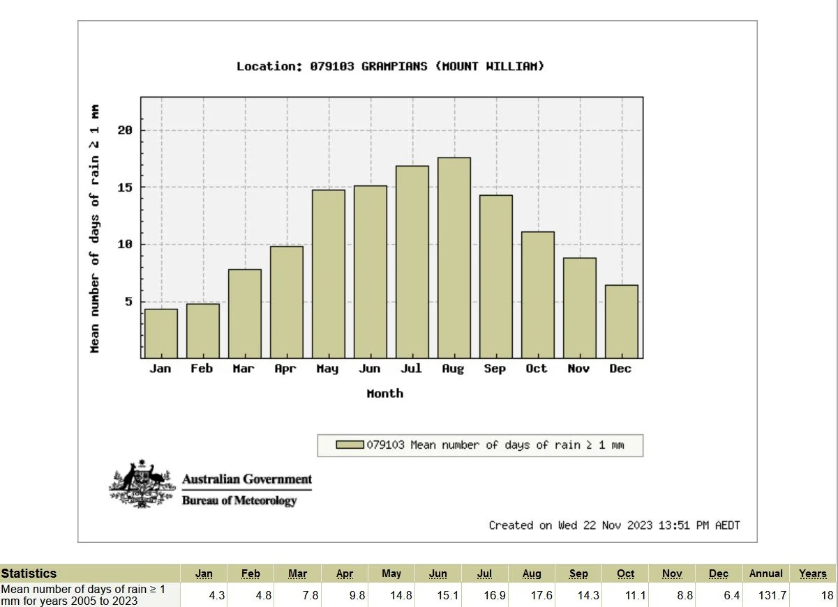
Monthly Mean Number of Days of Rain (Image Credit: Australian Bureau of Meteorology)
Storms are most common in winter and spring but can occur at any time. Extremely exposed sections of track are dangerous in strong winds, in thunderstorms and in whiteout and you should not set out on them if the forecast is bad. Here are some useful links:
https://www.mountain-forecast.com/peaks/Mount-William/forecasts/1167

Monthly Mean Minimum Temperature (Image Credit: Australian Bureau of Meteorology)

Monthly Mean Maximum Temperature (Image Credit: Australian Bureau of Meteorology)

Spring
For botanists and wildflower enthusiasts, early- to mid-spring is a no-brainer. Some parts resemble gardens, with breathtaking sweeps of colour. However, spring weather is highly changeable so you can expect anything from rainy cold days to clear, sunny 30C+ days — we experienced both and everything in between. Nights can be extremely cold so don’t underestimate them: tent platforms provide little insulation and we strongly recommend a warm sleeping bag (0C comfort level, warmer for cold sleepers) and mat.
Summer

Pleasant today in October, but still relatively warm on the open rock that you are traversing much of the time. On sunny days, you can feel the heat radiating back up at you.
Australian summers are hot and dry. We do not recommend hiking in mid summer (January-March) not just because of potential heat — you will need to carry extra water, doubly so if campground tanks are dry — but also because of bushfire risk: parks will close at short notice on forecast catastrophic fire days. Of course this depends on the season but we suggest that, if you really want to hike in midsummer, you check the forecast and book at shorter notice (fewer hikers are likely to be on the track at this time of year and booking will be less competitive).
Autumn
Autumn usually has the most stable weather pattern. It’s cooler but still dry: you may need to carry as much water as in summer because some campground tanks are likely to be empty. If you delay until after the first autumn rains, you’ll find plenty of fungi, and more animals will be out instead of hiding from the heat.
Winter
Although this hike is challenging in winter with low temperatures, days of rain and terrain that becomes slippery after prolonged precipitation, many people enjoy winter’s special ambience. Winter orchids are out, and August brings the first flush of wildflowers. Orographic and low cloud mean you may miss out on a few views, but clear cold days bring a joy all their own. Photographers appreciate the often dramatic light and cloudscapes. Check forecasts carefully as storms and whiteout conditions on the higher reaches are dangerous.
Booking
The Parks Victoria booking site was a nightmare when we tried in early 2023 and we ended up ringing so that we could spend more than one night in Halls Gap. Fortunately, it is now much improved, with far more flexibility. You may still want to ring if you are planning a non-standard itinerary, for example 3 nights in Halls Gap (at time of writing the system allowed 3 nights, but subsequent dates didn’t change correspondingly). Should you want to try our slower hiking itinerary tweaks you will have to book individual sections: see Geoff’s slowerhiking suggestions below for more detail. When we hiked in peak season 2023, the booking system was still so awry that most nights there were only a few other couples at campgrounds.
At over AUD550 for campsites alone, plus track transfers, the GPT is not cheap. Unlike many other hikes where you book per person, the GPT is per campsite and assumes two people in one tent, ie one platform. AUD275 per person is still expensive, but of course it is twice as expensive for solo hikers. However, it is definitely possible to fit two small tents on one platform, and you will not be exceeding any prescribed limits by doing so when there are only two of you. Standard platforms meaure 3.5m x 3.5 m (3.83yd x 3.83yd); only Bugiga’s are circular. If price is important to you, we highly recommend that solo hikers cosy up in one tent or find a buddy with another small tent to share the platform and split the cost (do a test pitch at home). Alternatively, consider completing the GPT as a series of loop walks using the free campsites either side of the track. Larger platforms are more expensive and suit groups or families.

Two small Lanshans squeezed onto a platform (Image Credit: Rob Morgono)
How to Get There
For our overseas readers, the Grampians are in southeastern Australia:
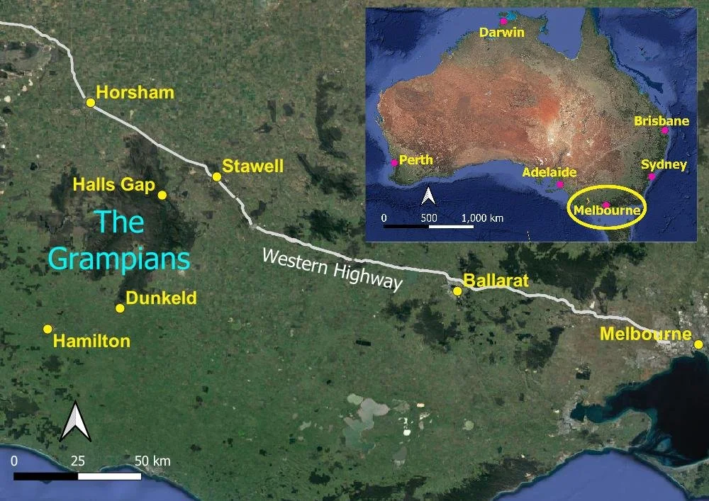
A short drive along the Western Highway from Melbourne
Without A Car:
The nearest capital city to fly into is Melbourne; Adelaide is slightly further away. From both of these cities you can catch buses and/or trains to Halls Gap, Dadswell Bridge, Dunkeld or Stawell. Here are some useful links:
https://www.ptv.vic.gov.au/route/1731/halls-gap-melbourne-via-stawell-and-ballarat/
https://www.travelvictoria.com.au/dunkeld/transport/
https://transitapp.com/en/region/victoria/v-line/bus-nhill-melbourne
https://railmaps.com.au/journeyplanner.htm
Once you are in Halls Gap or Dunkeld, track transfer companies can take you to the start of the track; these transfers aren’t cheap either, because distances aren’t short. The Grampians Peaks Walking Company has a scheduled service that runs on a timetable like other bus services (you still need to book). Experience the Grampians can be booked for a specific time and slower hikers may prefer this option because you can start earlier in the day. Caro Ryan has many excellent tips also.
With A Car:
Because this is a thru-hike, you’ll still need a transfer. Book transfers well ahead. This is what we did (you’ll need two nights in Halls Gap):
Leave your car in Hall’s Gap. Your accommodation is likely to allow this if you ask especially if, as we recommend, you are staying with them two or three nights after the northern section. There have been multiple reports of break-ins and theft from cars left in the Mt Zero Car Park at the start of the track.
Get a track transfer north to the start of the track and hike back to Halls Gap.
Because you have at least one day up your sleeve and are not continuing on the GPT on the day after your arrival in Halls Gap, one person in your party drives your car south to Dunkeld in the afternoon. En route, leave your food drop for the Southern Section at Jimmy Creek tank where the GPT crosses Jimmy Creek Road. You have numerous other options for additional food drops should you want them - see our tips on tackling some of the harder days. When you reach Dunkeld, leave your car at your accommodation (ask when booking) and walk to the Visitor Centre.
From the Visitor Centre, catch a track transfer back to Halls Gap.
The next day, begin your walk from Halls Gap to Dunkeld. Because your car is at your accommodation, you are under no pressure to reach town by a certain time.
Before leaving the area, drive from Dunkeld to pick up your empty food box(es).
Quite often after arranging logistics like this you hit upon improvements, but this worked very well for us and would be even more economical for groups of three plus. Alternatively for hikers going straight through Halls Gap, one person could drop the car at Dunkeld, and catch the transfer to the start of the track, their companion(s) joining them in the bus as it passes through Halls Gap (a full-length transfer is expensive).
Another alternative for a group means a very early start. The designated driver drops their companions at the Trailhead and they wait while the driver returns to Halls Gap or Dunkeld, dropping resupplies enroute if you have not yet done so. The driver then gets a transfer back to the Trailhead to rejoin their companions. If your group has two cars, use them for your own transfers.
What to Bring

Geoff bundled up with hot soup and merino baselayer, fleece midlayer, hat, 3 layer goretex windshell and rainpants against bitter wind, rain and cold… in mid October. We put gloves back on after lunch: wind chill was significant.
PLB or Inreach: the rough terrain increases the chance of injury and phone reception is not available throughout
Water, plus filter or sterilising tablets — be prepared to carry at least 3L pp, more in summer or when hut tanks are dry
First Aid Kit including snakebite bandages
Warm clothing: beanie, balaclava or neck gaiter, gloves, fleece midlayer, thermal baselayer
Good quality rainshell
Maps, mapping apps, compass (see below)
Sun protection year-round
Hiking footwear with grippy soles
Trekking poles with rubber tips
Warm sleeping bag and mat
Tent, line extensions
Food, toiletries etc.

Passing packs up through a narrow scramble.
We recommend keeping your pack as small and light as possible due to the elevation gain and scrambly nature of the track; see Geoff’s recommended extra food drops to help make your carry easier. The Grampians Peaks Walking Company in Halls Gap rents out packs, tents, cooksets, trekking poles, sleeping mats and bags.
Navigation
Official maps are detailed and accurate but, at time of writing, printed on crap paper. Ours tore even before we got onto the trail so we had them laminated (you can buy laminated ones here or here). We also downloaded AllTrails but found it mostly unnecessary as the route is relatively easy to follow if you’re not rushing; we checked only a couple places electronically. Apparently the sectional All Trails route is inaccurate: download the full route version instead.
We also highly recommend The Grampians Peaks Trail Guidebook, for navigation tips if you lack experience and for useful alternate itineraries; you can hike much of the GPT using side loops and routes if the cost of the official campsites is too high for you. We provide our own specific slowerhiking itinerary modifications and suggestions below.

Spot the trail marker!
Triangular yellow navigational markers are generally well-placed; if you’re traversing rocky terrain look for worn, lichen-free areas of rock, and pause to scan for those yellow markers. Branches and debris laid across a side track or route mean ‘don’t go this way!’ In the southern section you’ll see almost no trail markers. There’s the odd yellow stake here and there but in this section the trail is usually obvious with no alternative place to walk. We found the side track to Mt Gar the trickiest but even there we didn’t stray far.
Campsites, Facilities and Town Accommodation
Halls Gap has a campground, cabins, B&Bs and motels, with excellent cafes and pubs, a supermarket and a hiking supply shop. Dunkeld is smaller and has B&Bs, cafes and a modest supermarket. The pub has restricted opening hours.
On the track, campground facilities are excellent, with a few quirks.

Large enclosed huts with seating, tables and a steel bench for cooking at seven of the eleven campgrounds. Strangely, one hut has no doors.
The remaining four campgrounds have seating and curved windbreaks that look pretty but are sometimes unfortunately oriented; several funnel wind:

One of the ‘Communal Gathering Places’ that replace huts in four of the campgrounds.
Wannon has only (very hard) compacted tent pads but all others have timber platforms; a few have both. Chains run towards the centre of tent platforms; some but not all platforms also have wire around the outside edge. The increasing number of hikers with non-freestanding trekking pole tents should carry line extensions and brush up on their anchoring techniques, not least because, somewhat incredibly, the platforms have been constructed without gaps in the timber. Narrow gaps have started to develop here and there as the wood shrinks, but not consistently. Standard red aluminium fishbone deck hooks will mostly not fit the few gaps there are; our thin stainless ones fit more of them.

Pretty platforms but no significant gaps. Really?

Toilets at all GPT campgrounds.

USB charging stations inside huts or, as here, on a little shelf under the veranda of toilets at campgrounds without huts.
Water
When we hiked in spring, all campsites had water, but the tanks cannot be relied upon year-round and you should always check with recent hikers or your track transfer company. With the exception of Bugiga, those campgrounds with shelters have relatively large tanks associated with them. Bugiga’s shelter, designed for bushfire resistance, is not amenable to catching water so this campground has a smaller tank at the toilets, too. The tap at Bugiga is (still!) not spring-loaded, so the tank can potentially drain completely as happened to two hikers we met who had been through the previous year: the tank was empty despite Parks assurances that water was available.
The four campgrounds without shelters also have only small rainwater tanks associated with a correspondingly small recharge toilet roof area, and these tanks are likely to empty much earlier in dry periods. They are also likely to empty quickly when events are held along the trail or when large groups pass through.

Fortunately, you have reliable water points at specific road crossings between campgrounds. As you can see above, these tanks are small but they are kept topped up with trucked town water. We’ll provide more information about these water points in the northern, southern and sectional daily blogs.
You’re advised to treat water but we didn’t except at Bugiga, where Geoff (a hydrologist) couldn’t ascertain exactly from where the water was coming. Parks recommends that all water on the track, including tanks filled with town water, be treated. Of course treat any water collected from creeks.
Ways to make Days Easier
As always, there are practical ways to reduce distances or pack loads on many days, with fewer options on some of the hardest days. Here are tips to make this hike easier. Logistics seem complicated but, with the exception of additional track transfers, are simpler than they sound. You can:
Seriously consider spending two or even three nights in Halls Gap, so you are tackling some of the most difficult days well rested.
Book intermediate campsites to split days in half or even to have a(nother) rest day.
Arrange a pick up from intermediate locations and get dropped back the following morning after spending the night in Halls Gap
Use additional food drops to significantly lighten pack weight
Be smart about water resupply to lighten pack weight
Slackpack (using a transfer so you can hike with a daypack)
Start early

A food drop can contain not only food, but medications, fuel, clean undies, socks and even tees so you can refresh. Leave the dirty clothes in the box and retrieve them later.
Let’s take a closer look at these options.
Although our focus is supporting your E2E hike, there are numerous section hike alternatives. The Parks website has many suggestions and track transfer companies, Experience the Grampians and Grampians Peaks Walking Co also provide helpful tweaks: discuss it with them when you book your sectional hike transfers.
Experience the Grampians offer flexible service arrangements with transport options in both directions for 1-3 people (in a 4WD) or 4-22 people (in a bus) to many locations, whilst Grampians Peaks Walking Co provide scheduled transfers for groups and individuals from south to north with numerous drop off points along the way. We used both companies during our E2E hike and found them punctual, friendly and reliable. Both offer good but different services.
Booking campsites is straightforward for the conventional 12 night/13 day schedule, but is more complicated if you are doing things differently. The system has been improved from when we booked (we had to book a series of linked day and section hikes) so it is now possible – although cumbersome - to book individual nights. Booking linked sectional hikes is now reasonably straightforward.

Pleasant campsites at Jimmy Creek Campground
Helpful intermediate camping options need to be booked separately as well. These are available at the following locations:
Trail Head to Baringar - Coppermine campsite
Baringar to Gar - Troopers Creek campground
Bugiga to Barri Yalug - Borough Huts Campground
Duwul to Durd Durd - First Wannon campground
Durd Durd to Yarram - Jimmy Creek Campground
They also allow a rest day in camp as you can book them for multiple nights (excluding First Wannon). All the standard hike-in campgrounds can only be booked for one night.

First Wannon has a toilet, small and larger campsites

One of the larger campsites at First Wannon
Track transfers from several trail access points also let you split a couple of days.
Halls Gap to Bugiga – transfer to Wonderland carpark returning to Halls Gap with a day pack, restart your hike the next day with a return transfer to Wonderland car park. This removes a significant climb out of Halls Gap that you instead descend.
Barri Yalug to Duwul – Bypass this demanding day completely with a transfer from Borough Huts campground to Mount William Car Park (or Middle Gap if you would still like to camp at Duwul).
Barri Yalug - Duwul - Durd Durd – A transfer from Borough Huts campground to Jimmy Creek campground allows you to bypass the two most difficult days so you can enjoy rather than endure your hike if you’re struggling. There are still many great views and experiences to be had south of Jimmy Creek!
You could of course do this from most road crossing points along your hike with a transfer back into Halls Gap – for a fee!
There are many supported food drop locations so use them as necessary to lighten your pack weight. We had a drop at Jimmy Creek for the Southern Section, but an additional food drop at Borough Huts Campground halves the food weight you carry out of Halls Gap for the Central Section.

Griffin Trailhead has a water tank and 4WD access for a food drop
Serviced water tanks are usually - but not always – located a short distance north of campsites so if you are concerned that the water tanks at the campsite may be dry, you still often don’t need to carry water for your evening meal or for the next morning – southbound hikers can fill up within a few kms before reaching the hut. Use this track configuration to your advantage when it is available.
Leave No Trace and Safety
Please, PLEASE ALWAYS use the sanitation stations to thoroughly clean not only your boots but also your trekking pole tips. This is to help prevent the spread of cinnamon fungus, which kills native plants, especially some of our most totemic and important ones.

Boot cleaning stations: please use them! We very much hope one is soon installed at Griffin Trail Head so the disease in the picture below isn’t spread into the Serra Range, which appears clear thus far.

Grass Trees (Xanthorrheas) are highly vulnerable to cinnamon fungus that is being spread along this section of the GPT. Grass trees and banksias are essential habitat for all kinds of small creatures such as pygmy possums. When grass trees and banksias disappear, so do all the animals and birds that live and/or feed on them. The yellowed plants in the background have succumbed; the ones left foreground will be dead soon too.
Please carry out all your rubbish and keep campsites clean of food scraps. Somewhat surprisingly — and counter to advice for every other track we’ve hiked — we were told not to hang our food (from a thin line) in huts but to keep it in our pack in the tent vestibule.
People with vaginas, please use a pee rag (carry two and use one while the washed one dries on alternating days) or empty your ziplock of pee paper into the toilet at the end of each day.
People with an anus, try to time poo stops for toilets. If you’re caught short between campgrounds, find a less-rocky spot well away from watercourses and 50m from the track and dig a 20cm deep hole. After doing your business, throw in a handful of your excavated top soil and mix with a stick to help speed decomposition. Then cover the lot with more topsoil and firm down. Avoid moving rocks.
Please use rubber-tipped trekking poles to avoid marking rocks (replacement tips are available from Absolute Outdoors in Halls Gap). Remember to clean them at stations together with your boots!
This trail isn’t remote but its uneven footing increases the chance of accidents and injury. Phone reception is not universal. At least one person in each party should carry a PLB or Inreach/Zoleo. These can be rented from the Grampians Peaks Walking Company in Halls Gap.

Well then, what are you waiting for? Our Section Blogs are below. They include pictures of the track and campsites as well as elevation profiles so you know what to expect, plus suggestions for each day aimed at making the track more achievable. Reading the daily blogs in each section will give you a good idea of whether the GPT is for you; this hike is in Geoff and my Top Ten and we think it will be in yours too! We’re sure you’ll love it as much as we did, and you’ll feel proud of completing the more challenging parts. It is a truly fantastic hike and the memories you make will last a lifetime.