
Planning and Tips - A Nine Day Trek Combining the Hellismannaleid, Laugavegur and Fimmvorduhals Trails
This truly awe-inspiring hike links three trails in the central highlands of Iceland combining snow, ice, fire, volcanoes, lava and ash fields, waterfalls, glaciers, alpine lakes, rivers and steaming mudpots and hotsprings.

Our hike linked the Hellismannaleid, Laugavegur and Fimmvorduhals trails where we enjoyed many ‘otherworldly’ experiences.
‘Otherworldly’ is often used to describe places, but it’s rarely an accurate reflection. And yet, on this walk, we often felt we could have been on Mars, or in a fantastical world where at any moment a dragon or unicorn might appear. Revealed by extensive deforestation, volcanic activity and soil erosion, the colours of this tiny island are astonishing. The rhyolite mountains around Landmannalaugar glow in every shade of purple and green to white, black, orange, yellow and red, whilst the mountain-studded highland plain around Álftavatn is a colour we couldn’t identify, somewhere between turquoise and teal green. In many places, moss on distant hills was so golden bright than we mistook it for sunlight shining on rock. Hellismannaleid, Laugavegur and Fimmvorduhals are all stunning.
The total distance if they are all linked is around 142 km or 89 miles, with a elevation gain of 3,580m/3580ft and loss 3,660m/12000ft. For the most part the climbs aren’t excessively steep; there are a couple of exposed sections, but we found them manageable. The steepest sections are on the Fimmvorduhals.

Elevation profile

Spectacular volcanic landforms
No superlatives are excessive in describing this hike. The memories – and there is a new one around every corner of the track, multiple times each day – will last you a lifetime, never to be confused with any other place. It is literally extraordinary.
Planning and Hiking Resources
Maps: 1:100,000 Mal og Menning – 4 Landmannalaugar Porsmork Fjallabak, 1:100,000 Ferdakort – Porsmork Landmannalaugar
Online 1:50,000 map sheets and topographical map layers are available for download or on line viewing courtesy of National Land Survey of Iceland
Other resources:
Katie Featherstone’s excellent Laugavegur Guide
Walking and Trekking in Iceland by Paddy Dillon (Cicerone Press) – highly recommended.
https://www.facebook.com/groups/546699382189648
Best Time to Hike
July to very early September. Daylight shortens very quickly towards the end of the hiking season.
Transport
Flying into Iceland.
WOW air was expanding rapidly at the time we travelled and was notorious. Luggage was regularly lost or delayed, flights cancelled or rescheduled at short notice. Allow more time for connecting flights than the computer booking algorithms suggest. We literally ran from one end of Oslo airport AND BACK AGAIN when gates were changed as WOW flights were rescheduled. We took as many essentials as possible as carryon luggage – tent, all hiking clothes and rain gear, toiletries, twin quilt and mats: the advantages of ultralight gear! Only our tent pegs, hiking poles and kitchen went in the suitcase with the car camping gear (for further travel after our hike). If possible, allow a buffer day and night in Reykavik before you begin your walk, so a delayed flight doesn’t destroy your entire schedule.

With views like this we quickly forgot about our trekking back and forth at Oslo.
Buses
Buses travel regularly from Reykavik to or past:
1. Rjupnavellir (northern terminus Hellismannaleid),
2. Landmannalaugar (southern terminus Hellismannaleid and northern terminus Laugavegur),
3. Thorsmork (southern terminus Laugavegur, northern terminus Fimmvorduhals) and
4. Skogar (southern terminus, Fimmvorduhals).
A hiker’s bus pass (also here) allows the greatest flexibility in pick up times from Skogar at the end of your hike.
https://trex.is/tour/landmannalaugar/
Accommodation
These trails are popular. Huts along the Laugavegur and Fimmvorduhals book out 6 -12 months in advance of the short late June to August hiking season (you can’t go earlier due to the environmental damage you’ll do to thawing tracks and sensitive vegetation; weather deteriorates quickly in September, and some seasons are so cold that tracks require mountaineering experience even in early June). From 2026, campgrounds now also need to be booked — again do so well ahead of time.
The Hellismannaleid is much quieter – we were able to get into one hut just by turning up. The other dozen bunks were empty. On the Laugavegur and Fimmvorduhals we booked only two huts, Hrafntinnusker and Fimmvorduhals/Baldvinsskali at the highest elevations. One we booked successfully 6 months ahead, the other was a wait list reservation when a cancellation appeared. Recently, they have been booked out 12 months ahead, so a good solid tent is worthwhile.

Red roofed, green sided huts for rent.
We stayed in the campsite - Geoff is setting up the tent
You might find these links useful.
https://www.fi.is/en/mountain-huts/all-mountain-huts
https://nat.is/mountain-huts-in-iceland/highland/
https://nat.is/landmannahellir-cottages/
There is also a campground in Skogar for the end of your trip, or book one of the hotels. If you’ve bought a hiker’s bus pass, you won’t be locked in to arriving at Skogar at any particular time or day.
Like everything else in Iceland with a summer tourist population that, when we hiked, was about five times the population of actual Icelanders, accommodation is expensive. But access to the central highlands is along dirt roads with river crossings. It’s going to be expensive in an already expensive country.
We had booked for certain dates but, when we hiked into in Landmannalaugar, a storm was forecast for the next day and rangers would not allow people to begin the Laugavegur. We had scheduled a rest day here to provide flexibility for precisely this eventuality – there is more than enough to see to spend a day or two in the valley. The ranger explained that, in these circumstances, there would be no problem honouring our bookings at Hrafntinnusker and Baldvinsskali – much better for hikers to wait for safe conditions than set off in dangerous ones to meet a booking timetable. So this should set your mind at rest when booking.

A little cramped, but warm and welcome highland hut - after a day hiking in the elements there’s no problem falling asleep!
Finally, please don’t be That Guy. The huts are small. There are many hikers. The huts are first and foremost for safety. Despite what prices might suggest, these are not hotels. If there is a storm or dangerous weather, people will be squeezed in – on floors and in corridors – to keep everyone safe. If there is a delay due to whiteout conditions and no one arrives one night, and double are there the following … don’t be the person who browbeats the warden about this as the wind howls around the hut and horizontal rain batters the windows. We had booked a downstairs twin space but, when we arrived (slow hikers!) they were all taken … but of course we were in the chief that was a day late! We gratefully slept squashed up beside two Japanese women instead.
Food and Fuel
Because food is so expensive in Iceland, bring as many dehydrated meals with you as possible, checking current import allowances.
Basic food (instant noodles, soups, pasta, nut bars) can be purchased at huge expense from Landmannalaugar and huts to the south. Cheaper to stock up in Reykavik if you haven’t brought it from home.
Álftavatn has basic hot meals. So does Volcano Huts in Thorsmork.

Álftavatn hot meal: the soup of the day was very expensive but deliciously welcome!
The hardware store in Reykavik and petrol stations sell fuel alcohol (methylated spirits or Rauðspritt) coloured pink, and gas canisters. Check the latter are compatible with your stove. This is one of the reasons Geoff prefers alcohol fuel as it is widely available whereas compatible gas canisters can be hard to find. There are always lots of free fuel canisters at the campground near the airport (fewer at the hostel in town), as well as all kinds of food left by hikers finishing their trip.
Campsites
We paid for our campsites when we arrived at each of them. Some are small, some sloping, some crowded. Landmannalaugar can be muddy; volcanic glass shards surround Hrafntinnusker. A Tyvek footprint protected our tent floor and inflatable sleeping mats. We carried Gossamer Gear thinlight pads for additional insulation and emergencies should our inflatable mats develop a leak.

Small campsites, few of them flat, around Hvanngil Hut
Full-sized groundhog pegs and long guylines for all guy-outs on your tent are ESSENTIAL. We took a few additional guyline extensions and pegs. Iceland is one of the windiest places on earth!

The infamous tent-destroying Álftavatn campground. At elevation, winds here can be extreme.
A good 3+ season tent is important; you should know how to secure your tent for strong winds with a solid understanding of proper pegging and guying. The nature of Landmannalaugar means there are usually many inexperienced campers with a variety of tents. When we hiked, only a tiny proportion were properly guyed before the storm, and the majority of poorly secured tents – even quality ones – failed because of insufficient support. After the storm, many people left rather than starting on their hike, because all their clothing and sleeping gear was soaked, their tent flies torn, and their tent poles broken.

Landmannalaugar campground after a storm
Our Duplex served us well!
Our Slower Hike Itinerary
We planned our hike for around 15km/9.3mi per day and with only one day above 20km/12.4mi.
This was skewed on the Hellismannaleid with one long day, but if we’d stayed in Rjupnavellir the first night before heading off, then we’d have had Afangagil (19 km/11.8mi), Landmannahellir (22km/13.7mi), and Landmannalaugar (17km/10.6mi) the third night. Iceland’s long summer daylight hours means you’ll be able to cover these distances even at a slow pace. We recommend that slow hikers start their hike by spending the first night at Rjupnavellir before heading off as the bus arrives too late for slow hikers to make Afangagil on the same day.
The Laugavegur is traditionally done thus:
Landmannalaugar – Hrafntinussker (12km/7.5mi) – there is plenty to see and a lot of elevation gain, so we don’t recommend slow hikers continue to Álftavatn.
Hrafntinussker- Álftavatn (12km/7.5mi). Again, a lot to see, some snow, and a long descent. We had planned to camp here but arrived very early, so decided to push on another 2km to Hvanngil, making a very doable 14km/8.7mi day.
[Álftavatn to Hvanngil: 2 km/1.2mi, 1 hour. The campsite at Hvanngil is smaller but more protected than the one at Álftavatn.]
Hvanngil to Emstrur: 14km/8.7mi, 5-6 hrs. The undulating terrain allowed plenty of time to hike the 2km/1.2mi side loop from Emstrur into the canyon.
Emstrur to Thorsmörk (three hut locations: Husadalur, Langidalur or Basar): The most direct route is to go straight to Langidalur which is 15km/9.3mi. It’s also 15km/9.3mi to Husadalur which is where Volcano Huts are located with HOT MEALS and a HOT POOL! Going to Volcano Huts does however involve a detour and you will still need to go though Langidalur. There are a couple of detour options - the one we took added 3km/1.9mi to the following day (to get to Langidalur from Volcano Huts) but for us the hot shower and fresh meals were worth it. Once you get to Langidalur it’s an extra 2km/1.2mi to Basar.

Still smiling:
knowing there’s a hot meal and shower awaiting us at Volcano Huts tonight may help a little!
The Fimmvorduhals distances vary depending on where you’ve spent your previous night. If you’re feeling energetic, you could continue on the extra 2km/1.2mi (if you take the direct route or 4km/2.5mi if you go the high potentially more scenic but not so well marked high route via the Vestrihattur peak) to Basar Huts on the Fimmvorduhals Trail. This will give you more time the next day to make the 900m/2953ft ascent to Fimmvorduskali Hut (11km/6.8mi) or 12km/7.5mi to the Baldvinsskali Hut.
Fimmvorduskali Hut – Skogar 16km/9.9mi is all downhill.
The shortest, most evenly spread walking would be Emstrur-Langidalur or Basar, Basar-Baldvinsskali, and Baldvinsskali-Skogar. However, when we booked we couldn’t specify which of either Fimmvorduskali or Baldvinsskali huts we could stay at (we booked Fimmvorduskali but were given Baldvinsskali; the opposite might just as likely happen). No matter, it is no more than 1 km extra, no biggie either way.
Clothing, Navigation and Safety
Safetravel Iceland has excellent information.
Whiteout and storms are common in the Icelandic highlands even in summer. You will likely be hiking through snow. Bring appropriate layers (wool and synthetic, not cotton), excellent rainwear, insulating beanie, and boots or shoes that will be comfortable in snow. Trail runners are popular in hiking but, if you use them, consider waterproof socks so your feet stay warm.
Whilst we didn’t experience them, flying insects can be bad on the Hellismannaleid trail so it’s best to be prepared: we always carry light and effective fly nets in our packs.

wool thermals under fleece, and rainshells in our packs.
The Laugavegur and Fimmvorduhals are very well marked. The Hellismannaleid is a route that is mostly track; some bits are untracked and although the route itself is generally well signposted, and with white posts across plains, you do need better navigation skills than for the more popular tracks. Handrail navigation is useful in a treeless country like Iceland! We used paper maps and really only needed our gps for one day for navigation in poor visibility.
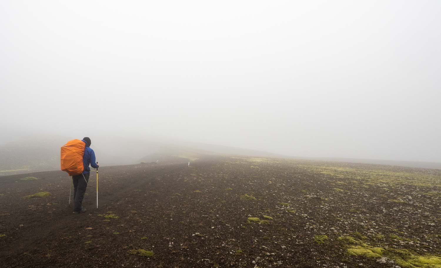
Poor visibility on the Hellismannaleid
Hire a PLB if you don’t own one. There is also an app for Android and iPhone to update weather conditions, but reception is spotty. Don’t expect to recharge batteries or phones in huts: carry a power pack or extra batteries if you think you’ll run out.
Listen to rangers if they tell you not to leave from Landmannalaugar in whiteout conditions. People have died even in midsummer, just a few hundred metres from huts. There’s little point in setting off anyway – the spectacular views will be hidden in cloud, and you’ll see more in the valley. Or you could, as many people did, spend all day in the hot spring!

Plenty to do in Landmannalaugar if rangers ask you not to start the Laugavegur!
And plenty to see in the valleys around Landmannalaugar without ascending to the highland plain:

Spectacular country around Landmannalauger.
Leave No Trace (LNT) Principles
PLEASE RESPECT SIGNAGE AND RESTRICTIONS
Iceland is a tiny island that receives millions of visitors every year. Much of the vegetation is extremely sensitive to trampling, and takes not months but decades to recover from disturbance. Respect signage, stay off sensitive moss, stick to tracks. Respect restrictions on wild camping in Reserves and Parks.

Fantastic to see the above sign is working.

If there’s a sign, take your selfie somewhere else just as beautiful . There is always somewhere else just as beautiful in Iceland!

Mosses are especially sensitive to traffic and can take decades to recover - so please respect signage.
Poo in Loos!
Millions of visitors produce a lot of poo. Every town has a park or even just a paddock with a toilet where you can camp. You’d hardly think this would need saying, but playgrounds, front yards and schoolgrounds are not toilets! And yes, all of these places have been used by tourists!
Iceland’s short warm season means that organic matter takes a very long time to break down. Your crap and toilet paper, even when buried, takes years to decompose. Worse, repeated freezes and thaws are likely to pop your leavings back to the surface. Along the track, hang on and use hut toilets.

Farmers really shouldn’t have to put up signage like this!
Carry out used pee paper
We women are responsible for a lot of discarded toilet paper. Use a Kula cloth (buy two, wash one each night and alternate). If you use pee paper, carry it out, don’t bury it or leave it. Unless you have an UTI, pee is sterile. Carry a ziploc bag in an outer pocket of your pack, and put your used pee paper inside it. Or just put it in your rubbish bag with all your other rubbish. Squeamish? The alternative is coming across the used paper of everyone else who feels the same. That’s much, much yuckier!