
Day 21: Mulga Camp to Simpsons Gap, (Sect. 2 Part)
Easy walking, wildflowers, rivers, plains and gaps

Evening light at Simpson’s Gap
Today’s Hike
Today’s 16.9km/10.5mi (including a 500m/0.3mi side trip to Bond Gap) hike follows the flanks of the range and crosses undulating terrain broken by wide impermanent watercourses. Take a short spur trail to visit pretty Bond Gap, then return and continue to Simpson’s Gap, whose notch you can see for miles. Nearing the gap, the trail joins the Woodland Circuit Walk, taking a strangely and somewhat annoyingly circuitous route so that it seems to take forever to reach camp, perhaps to make it interesting for day hikers!
There’s a rotunda and barbecue area at the gap, but travelling west to east you first reach the campsites and hut, tucked amongst mulga a little higher up the hill. Set up camp and visit the Gap now to see the rock wallabies, or early the next morning. You’ll find public toilets and a satellite phone dish at the car park so now is the time to make calls to alter bookings in Alice Springs if needed.

Nearing the end of your journey!

One of the longer days on trail, but with little elevation gain or loss, and the track is largely smooth underfoot.
How to Make Today Easier
Although today at 16.9km/10.5mi is one of your longer days on trail, you have relatively little cumulative elevation gain and loss, and it’s spread across the day as numerous smaller climbs and descents rather than a single big one as has been the case on other days. The trail is also straightforward underfoot, without the bouldery creeks or steep rocky scrambles of previous sections. West to east hikers who have come this far are likely to find the terrain easy.
Nevertheless, start early to give yourself plenty of time to cover the distance; omitting Bond Gap shaves 500m/0.3mi from the total distance but it’s a pretty spot and, being about halfway, ideal for lunch. A (now) emergency campsite in a sandy creek bed is marked on the Parks Map about 4 km west of Bond Gap, but it isn’t well-placed for west to east hikers. No camping is permitted at Bond Gap. If you are struggling to make Mulga due to injury or heat, check your topo map for watercourses with their resilient sandy beds as emergency campsites.
Walk with Us:

Prepare for all kinds of weather on this trail! Like us, in winter you’ll likely experience hot and dry, cold and wet, sunny, and overcast conditions. Today, low cloud obscures the range in the background; the mild conditions are perfect for hiking!

No need for a hat this early in the overcast morning!

Although you’re walking through more and more buffel grass, keen-eyed botanists will continue finding new plants even in the less-pristine ecosystems closer to Alice Springs, here Perennial Sunray (Chrysocephalum pterochaetum).

You get a good idea of today’s undulating terrain here, with little rises capped with rocks, followed by…

… sandier stretches in the dips and flats.

Inviting rockpools in the bed of the watercourse.

Not today!

The evocatively-named Dead Finish (Acacia tetragonophylla). Each phyllode is tipped with a needle-sharp thorn.

Veined Peppercress (Lepidium phlebopetalum)

You’ll see and cross several impermanent water courses snaking across the flats.

Rock slabs and sand…

Again, if you need an emergency campsite in the dry season, you need only look at the topo map to find those watercourses with their sandy beds.
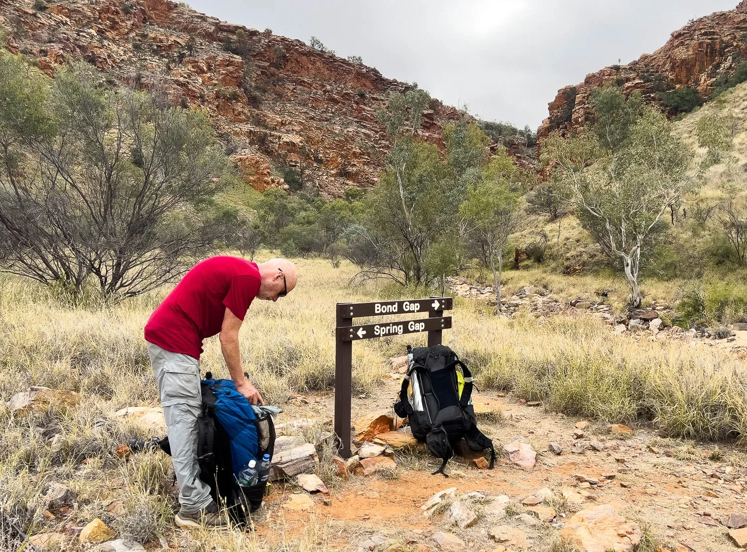
Leave your pack at the start of the spur trail and take a day pack with lunch, water, first aid kit and emergency comms to Bond Gap.

Bond Gap is secluded and cosy, with a small grassy knoll from which to enjoy the fish in the pool and the flitting insects above the water.

Once you’re back on trail, unmistakable Hat Hill dominates the landscape.
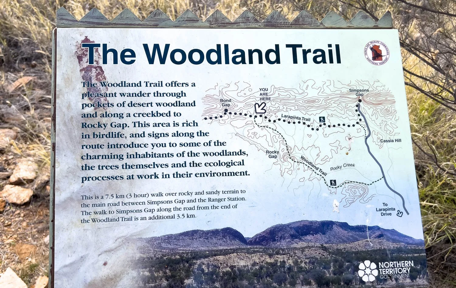
About 7.1km/4.4mi from the campsite at Simpson’s Gap, the Larapinta Trail joins the Woodland Circuit Hike, a day walk from Simpson’s Gap. It doesn’t appear so on the maps, but the trail meanders a great deal, or perhaps I am just tired and sore! The full circuit excluding Bond Gap is about 18km/11.2mi.

Still fantastic terrain.

Fabulous mille-feuille (not an official geological term!) rock formations.

And finally you near Simpson’s Gap. But wait, the trail takes one last long looping detour to the west!

The same excellent, practical hut as elsewhere. It will be your last one, for there is only an open-sided rotunda at Wallaby Gap.

Plenty of flat, shady campsites a pleasant distance from the main carpark, rotunda and barbecue closer to the Gap.

Preparing dinner in the hut. Another hiker also has an alcohol stove, the bomb-proof time-tested Trangia. Our Caldera Cone works on a similar principle but is simply a lighter, more efficient but less robust version. We carry just one pot and no plates or bowls; one of us eats out of the rehydration bag or large mug while the other eats out of the pot. Compare this with the full Trangia set behind us. If carrying a set like this, consider what you really need, and leave the superfluous components at home.
Paired with a highly efficient stove, our pot is also a little faster to boil water: it’s very light and conducts heat well, but is less suitable for actually cooking food than is aluminium. Aluminium is also much cheaper.
If you’re not sure what stove might work best for you, see our stove series.
Tonight is likely your penultimate dinner on the trail, so consider taking your kitchen down to the Gap and eating there instead. This isn’t really an option for us tonight, because an extended family group are celebrating there with cheerful Indian music, singing and mouth-watering food smells drifting up to us in the hut. After three weeks of dehydrated dinners — even with more than fifteen or so different ones (see recipes) — we have a major case of Food Envy and are eagerly anticipating the restaurants in Alice!
We respectfully acknowledge the Arrernte People as the traditional custodians of the land on which we walk and pay our respects to Elders past and present and to the Aboriginal people present today.