
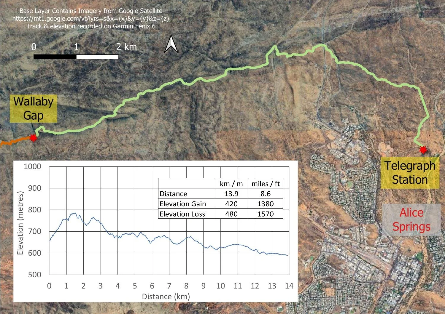
Day 23: Wallaby Gap to Alice Springs (Sect. 1, Part)
Spectacular views from a knife-edged ridge

Traversing spectacular Euro Ridge

Your last day!
Today’s Hike
It’s your final 13.9km/8.6mi day to Telegraph Station, or walk all the way into Alice Springs (approx. an extra 4 km/2.5mi). From what you’ve read, you might expect the terrain to be open but, although it’s less rugged than the ranges further west, you start with a long and exhilarating climb out of camp and then along the spine of Euro Ridge with marvellous views the entire way. Once you descend, you gradually begin to encounter railways, roads and bridges, and to hear traffic. Nevertheless the last few kilometres into Telegraph Station offer new culture, history, landforms and geology, with mica sparkling like glass everywhere you look. It’s a delightful way to ease out of a hike.
Larapinta-style ‘downhill’ all the way, with almost equal cumulative gain and loss!
How to Make Today Easier
Once again your biggest climb for the day for West to East Hikers is straight out of camp in the morning when it is still cool; start early if the forecast is hot. West to East hikers who have made it this far will not find the day overly challenging.
The best way to make the day easier is to finish at Telegraph Station rather than adding the extra 4km/2.5mi into town; call a taxi or an Uber from the shelter at the track terminus as we did.
Walk with Us:
It is your last day on trail, always bittersweet: you will soon move on with your life, the trail becoming a lifelong memory. Cold drinks, hot food and a soft bed are likely beckoning, but it’s worth trying to remain in the moment to enjoy every last step of this amazing experience.

Paved track and steps straight out of camp: luuuxuuury!

And even on this last day, botanists will find new plants, here Ixiochlamys filicifolia

Soon you are climbing the northern slopes of Euro Ridge…

… with grand views behind you.

Once you’re up on the ridge, breathtaking views to the east…
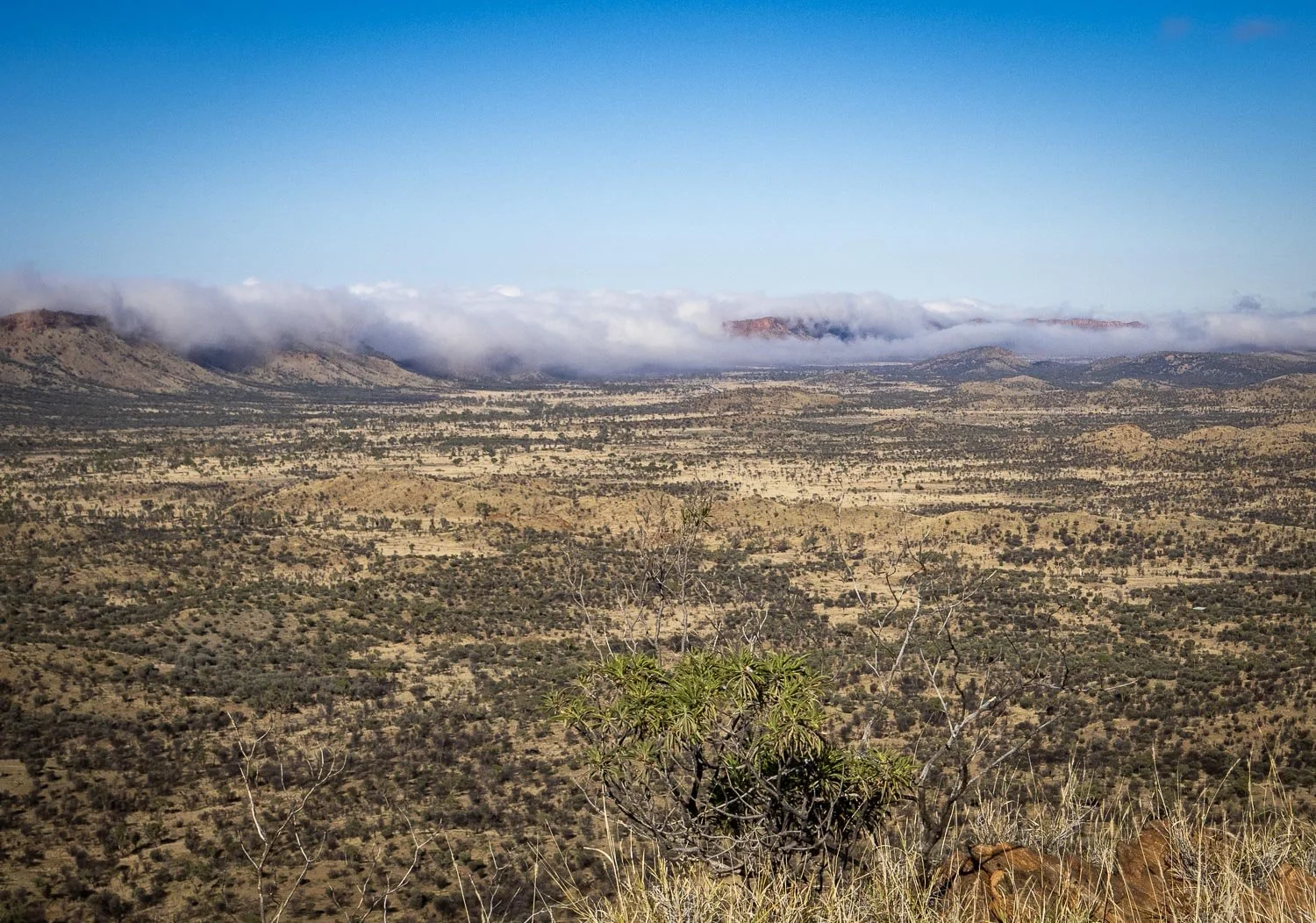
… and the south, here with clouds spilling over the Heavitree Range.

The track follows the very edge of the escarpment!

Look behind you, all the way to Mt Sonder on the horizon where you began.

Western Storksbill (Erodium cygnorum)

After following the ridge for about 1km/0.6mi, you drop off to the north through undulating country, gradually descending to the plains.

Views across Burt Plain…

… but of course, the plain isn’t flat! The trail contours its way through countless dips and rises.

It has been very dry with many fires, and the plants reflect this.

This section on the northern side is hot and exposed, with almost no shade. Here’s Geoff, drinking in the last views from a cool spot.

You’ll go under the bridge, across the railway, and into rocky country once more.

The trail follows the Charles River for a short distance.

Mica sparkles like fish scales everywhere at your feet…

…as you follow what’s left of the the original old telegraph line towards Alice Springs.

Oh my!

Your first glimpses of European history after being enfolded in the ancient landscape of the West MacDonnell Range. Here, a tiny cemetery with the graves of five settlers who died in the late 1800s.

You join the Trig Hill Loop Walk.

And finally you reach the Larapinta Trail Head with its little shelter. You will be somewhat grotty, but we’re sure you’ll have the same big smiles on your faces after this once-in-a-lifetime experience.
The Larapinta is deservedly one of Australia’s most famous walks, mentioned in the same breath as the Overland Track. Although it’s notorious for its boot-shredding rocks and heat and is not to be underestimated, we firmly believe that moderately fit slower hikers can enjoy this hike in the same way as we did.
With a conservative itinerary, light packs, solid preparation and realistic expectations, we did not find it more difficult than anticipated and, if you’ve looked at all the images in our blogs and read our Planning and Tips and Itinerary pages, you too will have a clear idea of what this marvellous trail entails.
But one thing was unexpected. The trail was far, far more beautiful and immersive than either of us thought it would be. The sense of the aeons was almost palpable, with wide sunrises, sunsets and elevated views dwarfing you to exhilarating nothingness in an ancient landscape. It is a hike like no other in the world, and we can’t recommend it highly enough.
Start planning!
We respectfully acknowledge the Arrernte People as the traditional custodians of the land on which we walk and pay our respects to Elders past and present and to the Aboriginal people present today.