
Day 3: Buoy Creek to Louisa River
Buttongrass, creeks and breathtaking views

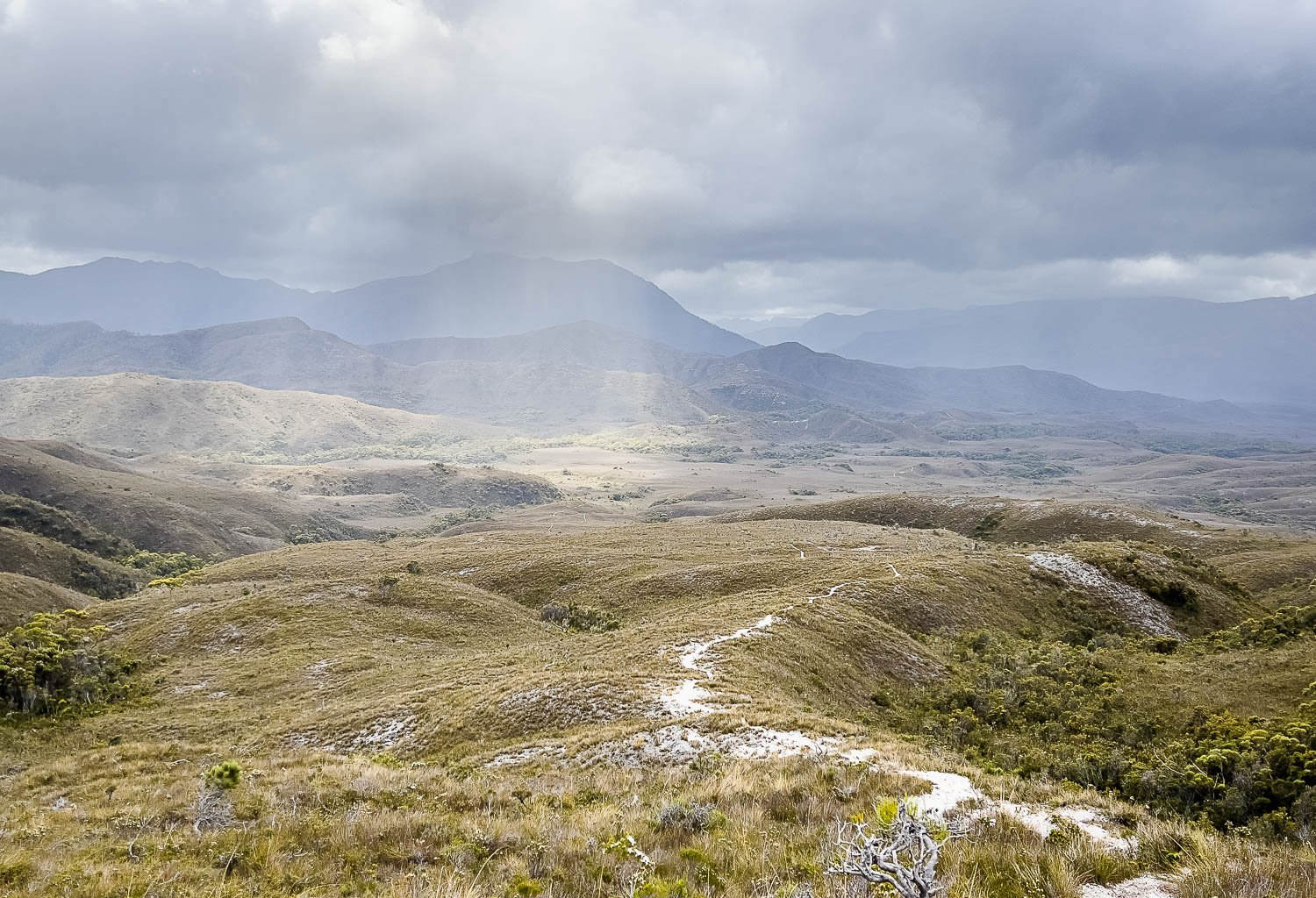
Climbing up Red Point Hills with plenty of pauses to absorb the glorious views.

Today's hike of 13.8km (8.6mi) heads inland, northeast across more buttongrass before a steep 225m (738ft) ascent in 800m (875yd) up Red Point Hills, followed by a slightly longer descent with expansive views to the Ray Range, the track itself the only sign of human activity. You'll cross a few creeks and, after heavy rain, may need to wait for Louisa Creek or the Louisa River to abate, a good reason to always carry extra food. The track is mostly excellent underfoot, with a few sections of broken duckboard towards the end of the day, and some steep rough sections on your climb. However, most fit, leisurely hikers should be able to complete the distance comfortably if they leave early.
Walk with Us:

Almost immediately out of camp, you emerge from the forest and head towards Red Point Hills across the buttongrass plain, with treelines on the flats marking Buoy Creek and its tributaries. The track is excellent underfoot here, with very little bog.

Nothing to complain about, with duckboard much of the way. You can just make out the trail snaking faintly up the central spine in the distance.

Crossing a small tributary, probably Billiarchie Creek.

Dappled sunlight on Red Point Hills. We saw no one on the track yesterday, and so far no one today: solitude very different to the Overland Track and the Larapinta!

We mention this regularly but it's important for hikers who dislike infrastructure to remember that boardwalk protects the environment. The erosion that develops on tracks alters drainage and turbidity in swamps far beyond the track itself. You need only look at the lush growth under the FRP boardwalk to see how well it protects the sensitive vegetation compared to the original track on the left.

Steep steps take you up the hills through flowering River Rose (Bauera rubiodes). Sections here are quite overgrown, but eventually you emerge into the open...

... to breathtaking views back over the morning's walk, and further across Cox Bight to Cox Bluff. But the views don't end there.
Once you reach the top – there's a tiny exposed campsite to the right – beaut new views open up to the north. You can see the track wending its way around and up and down little hillocks and spines way, way ahead.

Looking northeast with Mt Louisa looming beyond the lower hills.

The track is in amazingly good nick. By now you might be wondering what all the fuss is about. You will find out tomorrow!

Beautifully constructed steps. Enjoy them while they last!

A little more forest.

Pink Swamp Heath (Sprengelia incarnata)

Crossing Louisa Creek. Easy today, but levels can get much higher. When flows are strong, our conservative preference is to look for a crossing point where water is no deeper than just above the knee, but today it's easy. Dawgs sandals double as camp shoes and are safer than thongs (flip-flops) which are easy to lose in streams. Crossing streams bare-footed is a recipe for disaster and, in truly challenging crossings, hiking boots, waterproof or not, are your safest option.

Time for lunch at a lovely campsite on the banks of Louisa Creek. You could stop here, but tomorrow is one of or the most demanding days of the entire hike, so it's better to minimise the distance then instead. Only a little further to go.

Lots of little ups and downs: you're rarely on flat ground, and the landscape is captivating. We have met just one other couple coming the other way and it's hard to believe it's peak hiking season.
The SCT is certainly for experienced hikers due to its remoteness, terrain and climate, but we are both surprised – and pleased – to see so few people. Huts are proposed for this track but, in our opinion, this would be a disaster for the wilderness. There are plenty of other tracks with huts: why can't some tracks be left with minimal non-essential infrastructure? Toilets and duckboard on this hike are to protect the environment; huts will be for private operators and the government to make money. End of rant!

I have been walking past hundreds of closed and finished flowers of this beard orchid for the last two days. They are self-fertile, often pollinating without opening, but finally there's a slightly manky one still flaunting its hirsuteness, the Pale Beard Orchid (Calochilus herbaceus).

Short Purple Flag, Patersonia fragilis

Contouring around Spica Hills, with Mt Louisa beckoning you onwards. You won't be climbing her tomorrow, but the adjacent Ironbound Range out of frame to the right.

Some old boardwalk here...

... and some even more dilapidated, but it's only a short distance.

Sweeping Louisa Plain: the track is nearly all duckboard and you'll likely make good time. Tomorrow you'll be climbing that spine centre right.

Here you can see tomorrow's track more clearly, up through the centre of the sun-dappled patch, then zigging right before zagging left again to the crest (a false crest, there is more beyond!).

A few short dodgy sections but most is in excellent condition.

More Prasophyllum concinnum in a recently burnt area near Louisa River.

Crossing Louisa River.
You'll find nice campsites on both banks and for the first time we see half a dozen people, plus four tents pitched on the western side. We ask about tomorrow's infamous Ironbound Range traverse and receive different replies. Some are dismissive, others suggest it's tough. No suprise, really, as it depends on your fitness, strength, stamina, agility and expectations, whether you're climbing or descending and which you find easier, whether you're under time pressure, the weight and size of your pack, your footwear... the list goes on. We will have to just suck it and see.
After rain, the Louisa River can rise quickly, and you may need to wait for it to subside before crossing (hence campsites on both banks). Hikers have been held up for days or have even had to turn around at various crossing points on this track. If you camp at a river with sites on both sides, always cross when you arrive in case there is rain overnight. Again, carry extra food.

And here we are at Louisa Campground East, with sheltered, nicely-spaced sites. You can see our food bags hanging and this time we made a good call, as during the night something boldly had a go at my pack in the (open) vestibule. I switched on my headlamp and looked straight into a spotted quoll's beady eyes. I don't know who was most surprised, but I was thrilled to see this beautiful little marsupial for the first time in the wild.
I'm slightly apprehensive about tomorrow, but Geoff's itinerary is particularly conservative on this remote track, and he's tailored it to my strength and fitness. It should be just the right level of challenge!
We acknowledge the Tasmanian Aboriginal people and their enduring custodianship of lutruwita (Tasmania).