
Day 4: Louisa River to Ironbounds Low Camp
Steep climbs to montane terrain with expansive sea and inland views, and a demanding descent through lush rainforest

A little breather with a view.
Today's elevation profile explains some of the story, but not all. After leaving camp, you're quickly out of the forest and into open country with marvellous, ever-expanding views over Louisa Bay as you climb 850m (2789ft) onto the Ironbound Range. Australian hikes generally don't do switchbacks and the trail is rough and steep. It's extremely exposed: wonderful in good weather, horrendous in bad.

Once on top and with the climb behind you, you're in montane vegetation with yet more views to the Arthur Range. You might think the hard part is done, but the notorious Ironbound descent has defeated numerous hikers, specifically their knees and ankles!
Sheltered southeastern aspects of mountains in this region are usually covered in lush, dense rainforest. These faces are often steep and wet, rooty and rocky, in this case extremely so. You're also ducking under and over branches and bigger timber. It is slow going even for relatively fast hikers. How will slower hikers fare?
We left Louisa Campsite at 7am and arrived at Ironbounds Low Camp at 5pm ie 10 hours, minus about an hour for second breakfast and lunch. The descent itself took us 4 hours: I'm slower up hill than down, and Geoff is the opposite. To our surprise, our descent times were not much longer than that of other hikers we met. If we can do it, so can you!
How to Make Today Easier:
Start early to maximise daylight hours.
In bad weather — snow can fall on the top of the range even in midsummer, and it is extremely exposed in strong winds — delay. This has less to do with making the day easier, than making it safer.
Utilise intermediate campsites: we recommend stopping at Ironbounds Low Camp rather than pushing on to Little Deadman’s Bay, which is the conventional camp. The map implies you’ve done most of your descending, and that Little Deadman’s is only 3.3km (2mi) further on, but the terrain remains demanding; it took us 2 hours. In the dark, it would be worse. If you plan for Ironbound Low Camp and arrive early, you can always continue, but if your itinerary requires that you must make Little Deadman’s, you have no flexibility. The next day, we caught up with two young hikers with whom we’d shared the plane into Melaleuca. They had walked into Little Deadman’s at 10pm and been forced to have a rest day there due to tiredness/injury. If you can’t make Ironbounds Low Camp, there is a small but serviceable Emergency Camp about 1km before it.
Don’t hurry. This sounds counterintuitive but the roughness and slipperiness of the muddy track claims many victims who fall or wrench joints. Slow and steady wins!
Keep your trekking poles handy, but don’t be afraid to stash them either: in some sections, your hands will be of more use grabbing onto holds.
Minimise your pack size and avoid having things hanging off the outside: they will likely be lost. You are squeezing under and between numerous branches and logs, not now and then but for hours. We met a strapping young man with a bulky, heavy 80L pack who was in a world of pain purely because of the size of his pack.
If you find rough descents signficantly more difficult than rough ascents, consider hiking this trail east to west.
Ensure you are moderately fit. The trail is challenging but doable, even for someone like me: I’m reasonably fit, but no athlete. Unfit people will struggle.
Wear footwear with grippy soles.
Having said all that, today’s walk is my favourite day on the track… in hindsight, not on the day! Definitely Type 2 on the Fun Scale of Adventure! The montane section and views are second to none, and we make camp comfortably before dark. Take a good look at the gallery slideshow in this blog and in Planning and Tips for a clear idea of the descent, remembering that the challenge is because you have hours of hiking with almost no intermediate place to stop early: the vegetation is too dense and the terrain too steep. Thanks to Geoff’s thoughtful, conservative planning, I could be proud of successfully tackling such a famously challenging day.
Walk with Us:

The track starts leisurely enough through rainforest beside the Louisa River.

Soon you emerge from the forest and begin your climb. The campsite is in that big patch of trees centre. Mt Louisa looms behind Louisa Plain.

The track is rough and steep...
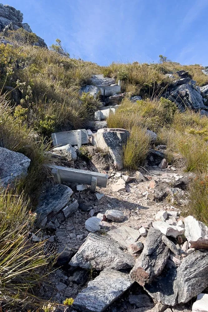
... and many of the steps have collapsed. Nevertheless the terrain is open, so you can use your trekking poles.

Even early in the climb, the views are already fantastic. What will they be like later?

A wolf spider mum with her babies, basking in the summer sun.

Amazing views over Louisa Bay with Louisa Island close to shore on the right, and the Maatsuyker Group of Islands further out. We passed a side track to Louisa Bay yesterday, but it was too far for us to consider without adding an extra day into our itinerary. Faster hikers could drop their packs at the junction for an out an return, or stay at the campsite there.

As you climb, you pass below great jutting buttresses of stone, with interesting plants growing in their shelter.

You're also climbing into subalpine vegetation, here the Lemon-Scented Boronia, B. citriodora...

... and the Butterfly Flag, Diplarrena moraea.
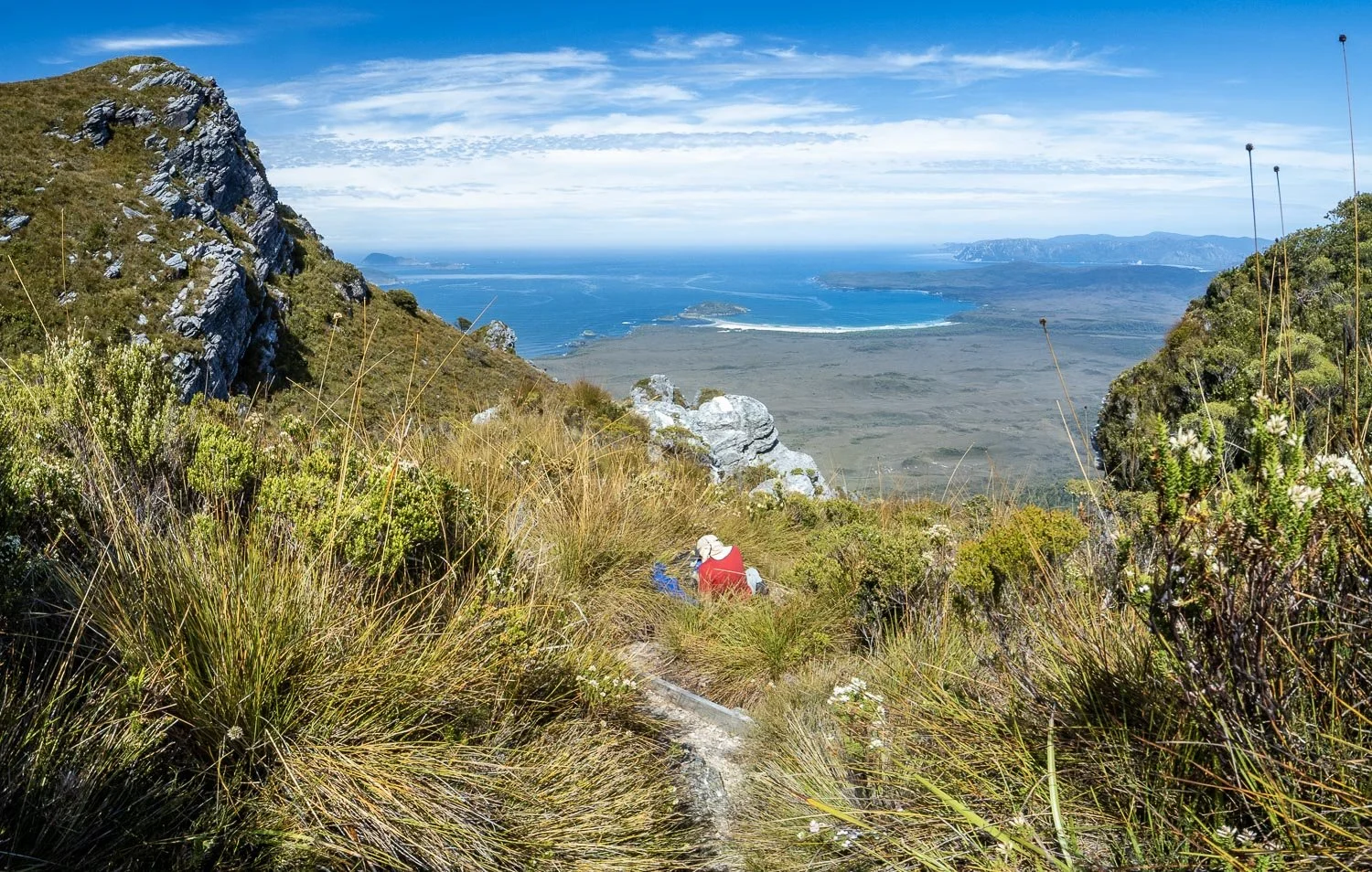
Pausing again to relish the view across Louisa Bay to Red and Cox Points and beyond.
It is fantastic, and just look at the weather! On recent days, and a few days after we are here, conditions are not so great: hikers had no views due to low cloud. Rain and wind are forecast for this afternoon, but we hope to be well on our descent by then.

As you near the top, grades ease, with duckboard protecting sensitive cushion plants.

Mountain Rocket, Bellendena montana. Botanists, keep your eyes peeled today, for it is the only section at this elevation and you'll see plants that occur nowhere else on the SCT.

Here comes the weather, but by the time it arrives you'll be in the shelter of the forest.

Down down down on boardwalk! You can see just how exposed this would be in strong southerlies.

Before descending too far, collect water from this little creek. Although the rainforest and track are wet, you cross no further watercourses between Ironbounds High Camp and Ironbounds Low Camp (though there is a creek 300m/328yd past it, so collect from there if you are happy to walk an extra 600m/656yd at the end of the day).

Olearia pinifolia

We pass a small, very sloping campsite that could be used in an emergency...

... and the muddy Ironbounds High Camp. Neither of these are inviting; they are definitely emergency camps.

Lunch with a view eastwards. Stop before you get into the forest, which is wet and shady without views.

After lunch, the real descent begins.

Common Heath (Epacris impressa).

Here we go!

Here's an 'open' section of track, complete with tree roots, rocks, mud, puddles, overhanging branches...we're in Southwest Tasmania!

And of course, there's now deadfall too and the first spits of drizzle. Time to don the rainwear!
After a couple of hours of ducking, slipping, clambering, weaving and sploshing we are nearing the base of the main descent.

Here is the emergency camp, with one small but appealing site on each side of the track. Lower Ironbounds is 1km (0.6mi) further down.

And here, finally, at Lower Ironbounds Camp. A few sites, only one big enough for the XMid, and it has stopped raining! There is only the odd leech (others have reported more) but some areas are unpleasant with poorly buried waste. You need a proper toilet trowel like a Deuce of Spades to cut through the rooty substrate. Please buy and carry one because a stake, trekking pole or stick literally won't cut it.

We made it! Yay!
What a day it's been: other slower hikers will no doubt feel equally proud when they complete this section! Strangely, the descent was not as difficult as expected, most likely due to stopping here rather than continuing to Little Deadman's, and perhaps because my apprehension exaggerated the challenge in my mind. And now here we are, cosy in our tent at dinner time (our favourite meals are saved for tough days, so bolognese is on the menu tonight).
We are both looking forward to an easier day with new views tomorrow!
We acknowledge the Tasmanian Aboriginal people and their enduring custodianship of lutruwita (Tasmania).