
Hilltop to Finke River (Day 4, Sect. 10 Part)
Water crossings, plains and a steep descent with expansive views

Wide wide wide country with the Pacoota Range stretching along the horizon, and not a building or structure in sight.

So much already seen and so much more to come!
If you stayed at Hilltop, today’s marvellous 10.4km/6.5mile hike takes you initially south down a rough and steep slope with switchbacks and fantastic views to Pacoota Range and the snaking treeline of the Finke River — your destination for the night — before you hit the Mereenie Valley with its scattered woodland and apparently flat terrain. However, like all of the trail, it is “Larapinta flat” with many small rises and falls, little gullies and Davenport Creek to cross. You pass fascinating rock formations and finally traverse the Finke floodplain with its tall trees and the river itself for a beautiful campsite on its banks, with the hut nearby for inclement weather.
We took 5.9 hours to get to the Finke campsite (including rest stops, sightseeing and meal breaks). If you’re following our itinerary, compare your times to ours each day. That way, when you reach the more demanding sections around Standley Chasm, you’ll know whether you will be faster or slower than us on those days, and whether you need to allow more time.

Today’s map.
If you stayed at Rocky Bar Gap, you start the day with the steep climb to Hilltop, followed by the steep descent for a total distance of 15.9, an elevation gain of 760m/ 2500ft and loss of 450m/1480ft.
How to Make Today Easier
Staying at Hilltop makes today much easier as it is only 10.4km/6.5mi with very little elevation gain, just 90m/300ft, and 450m/1480ft loss. Even us slower hikers should reach Finke River campsite early, perhaps just after lunch or mid-afternoon, with plenty of time to explore the river, lounge on its banks to watch the waterbirds, or to go for a swim.
However, if you busted a gut reaching Hilltop yesterday, the benefits of a short day now might not be worth it: your body will likely respond better with two moderate days than one demanding one plus one easy one. Of course only you know what works best for you, and even you may not have known until you arrived in Rocky Bar Gap yesterday. Stay flexible.
Walk with Us
The best-laid plans… so much for that spectacular sunrise!
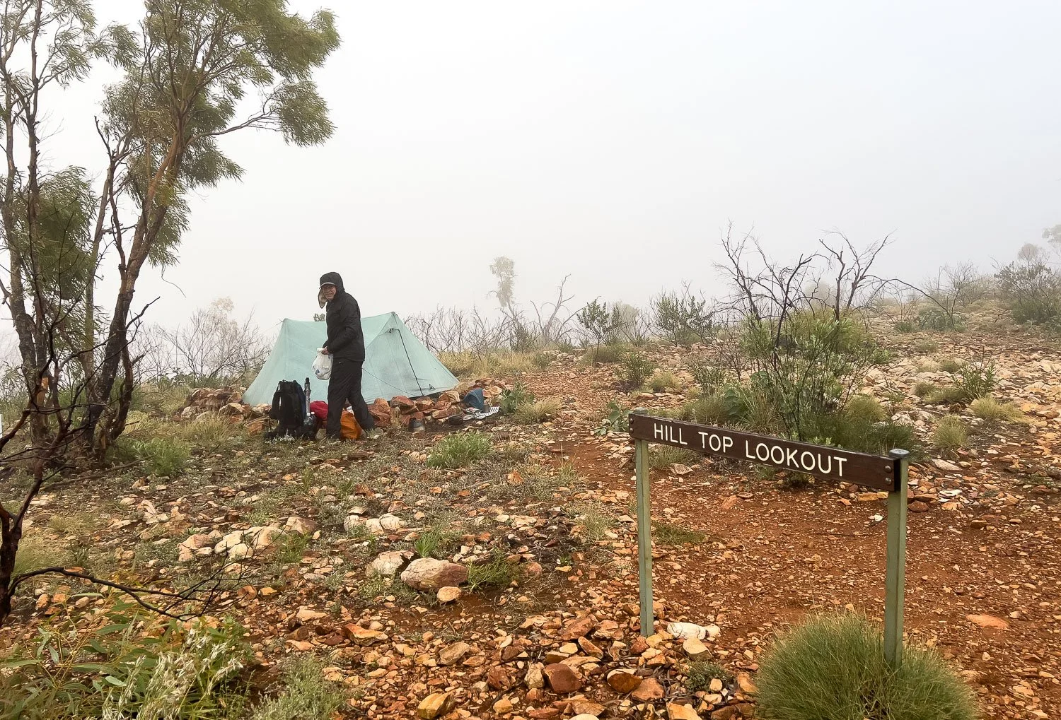
In fact, it’s drizzling, cold and windy. We stick our heads out of the tent early, but clearly there are to be no views of Mt Sonder: we can’t see fifty metres, let alone a couple of kilometres! Oh well, the sunset was stunning, and there will be plenty more sunrises on the track.

Breakfast (instant noodles with added protein and vegetables) huddled in the shelter of the rock wall after taking down the tent. Geoff is wearing his lightweight rainwear; the Visp has sadly been discontinued but the Outdoor Research Helium jacket should perform quite well here (we have the OR Helium pants).
Although you definitely need to carry a rain shell on this track in winter because it sometimes gets cold and wet, you don’t need the same heavy duty performance as for, say, the South Coast Track or alpine Tasmania; we wouldn’t take either of these jackets to those environments. We also carried rain pants, as much for warmth as for rain protection. Whenever wearing rainpants, it’s worth using a sitpad or piece of tyvek to extend their lifespan.

It’s time to leave and, although the cloud has begun to rise with Sonder’s lower flanks emerging, the peak is still hidden in mist.
Also in this image, you can see that white siliconised sandstone and the rockiness characteristic of every high point. This is why it’s not possible to sweep aside a few loose stones to create a new campsite: all the sites that are sufficiently free of embedded rock have already been found and cleared. In many environments, you might see rounded or flattish terrain on a map and know that you’ll find suitable campsites. Not so on the Larapinta: the rock and/or spiky spinifex will effortlessly destroy your tent floor and fly.
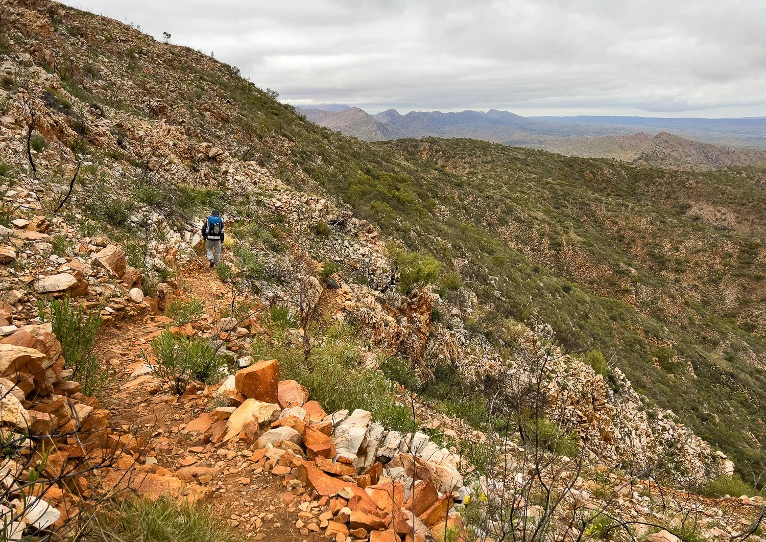
As soon as you leave camp, the descent begins. It’is steep but there are switchbacks and, ahead to the east, enticing glimpses of the range disappearing into the distance.

When we hiked, this descent had some of the the most diverse vegetation of the entire trail with hakea, acacia, eremophila, grevillea, senna and numerous other shrubs in bloom. Your mileage may vary, because flowering depends on recent fire regimes as well as rainfall.

Finke River mallee, Eucalyptus sessilis.

As you zigzag down the slope, your view switches from east, to south, to west as here.

Sections of the trail are extremely steep. In one spot — yay! — rustic steps have been constructed…

… but most of it is like this, rough and rubbly with a lot of loose rock. Trekking poles are your friend!

A trio of ghost gums. With their pale airbrushed bark and graceful limbs, these are surely the supermodels of the family!

The beautiful Sturt’s Desert Rose (Gossypium sturtianum). Similar flowers include the Australian Desert Rose (G. australe) and Hibiscus solanifolius.

Nearly at the bottom, and the plain stretches before you. From a little higher up, you will have seen the taller trees marking the banks of the Finke River snaking its way through the woodland.

To any ecologist, healthy spinifex grassland is extraordinarily beautiful. The tussocks allow countless forbs to grow between them, as well as other grasses. Their prickliness is protective, so they are home to the region’s small mammals, reptiles, insects and even birds that shelter in them from heat and predators.

Conversely, Buffel grass (Cenchrus ciliaris and C. pennisetiformis) is a horrendous weed of national significance that is devastating entire ecosystems in central Australia. Introduced initially as cattle feed (like many such introductions, this failed) it grows up to 1.5 metres in a thick carpet that smothers everything else. Worse, buffel grass burns extremely hot… so hot that overstorey trees are often killed, unlike in the cooler fires of burning spinifex.
And there’s worse news. Buffel grass regenerates faster than native species and tolerates hotter burns so, every time there’s a fire, buffel grass creates an environment that increasingly suits it more, and native species less.
Although all Aussies know about weeds and cane toads, and the damage that cats and foxes do, few of us have heard of buffel grass because it is in our central heartland, and nearly all of us live in cities around the edges of our continent. Scientists and Traditional Owners are working together for solutions, but none of them are easy.

Wild Parsnip (Trachymene glaucifolia) is pretty and yes, its root is edible both cooked and raw.

You’ll see many different species of Mulla-Mulla, sometimes great swathes of of them as beautiful as any European field of wildflowers. Here, Hairy Mulla-Mulla (Ptilotus helipteroides).

Crossing Davenport Creek, my boots slung around my neck with laces tied together.
Sandals or slides sold by budget places like Target and Kmart, are much lighter and cheaper than hiking sandals sold in outdoor retailers. We bought Dawgs some years ago, more expensive than Target slides, but they have a heel strap so are more secure for river crossings (sometimes you can find Target models with heelstraps). Geoff wears the Dawgs women’s model because they are less chunky and therefore lighter than the men’s model.

The native Blistered Pyrgomorph (Monistria pustulifera) walks around rather than hopping like other grasshoppers. You’ll likely see them on the track.

More ‘Larapinta flat’ terrain.

I’m a plant nut, not a rockhound, but Anthony is a geologist and says, “It's Bitter Springs formation, approx 800 million years old. These rocks are carbonates (limestone and dolostone) and you can see very fine laminations in one of your pictures that are the original bedding of the rock. The red colouration is probably a ferricrete; an iron precipitation formed by groundwater reacting with the rocks.”

Many fine layers, like millefeuille!

The eremophilas, or emu bushes, are astonishing in their variety with about thirty species listed for the area. This is a very pink form of the Limestone Fuchsia Bush, E. freelingii.

… and the Crimson Emu Bush, E. latrobei.

An early lunch stop in a little copse to shelter from the heat. We often use our packs as back rests.

Our favourite freeze-dried feta reconsituted with water, pepper, a glug of olive oil and Geoff’s home-made sourdough seeded crackers: yum!

Down into the floodplain beside the Finke, chockers with Buffel Grass under the trees.

A short shallow wade through bullrushes before we reach the river. I was distracted and didn’t take a photo then because hikers on the opposite bank waved and pointed south, indicating we should cross there. Sure enough, fifty metres or so away the river went undercround, so we crossed on sand.
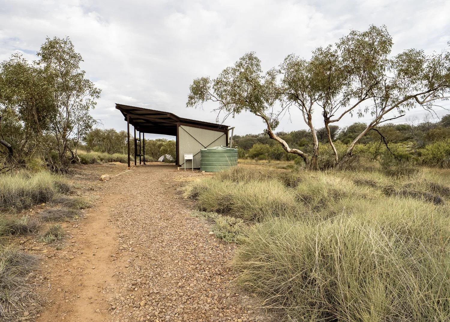
Here’s the hut…

…with scattered sheltered campsites amongst the mallee.

Plenty of beautiful spots on the banks of the river, too.

You’ll have time to go for a swim, rinse clothes and watch waterbirds coming and going. It is a delightful campsite.

Dinner on the banks of the Finke bathed in the light of a glowing sunset after another fantastic day of hiking. The Larapinta is awesome!
We respectfully acknowledge the Arrernte People as the traditional custodians of the land on which we walk and pay our respects to Elders past and present and to the Aboriginal people present today.