
Redbank Gorge to Hilltop (Day 3, Sect. 11 part)
Hills, woodland, wildflowers, a rocky gap and evening views make a fun and varied day

A spectacular view of Mt Sonder from Hilltop Campsite.

You begin your eastwards journey!

Today’s hike skirts the southern foothills of Mt Sonder ridge.
You’ll be weaving between low hillocks covered in woodland and spinifex before reaching Rocky Bar Gap. This is a perfectly pleasant campsite at a good distance but, if you have fuel left in the legs when you arrive, the weather is good, and it is still early, consider continuing through the gap an extra 4.7km/2.9mi to Hilltop Lookout campsite with its spectacular view of Mt Sonder. If you do this, remember to collect water from the tank at Rocky Bar Gap for tonight and tomorrow, because there is no water at Hilltop. It’s also worth using the toilet here if your bowels are amenable: you won’t be able to dig a cat hole on Hilltop, it is just too rocky. The track up to Hilltop Lookout is steep.
All up, including rest stops, sightseeing and meal breaks this day took us a total of 7.3 hours. It took us 4.5 hours to get to Rocky Bar Gap and an extra 2.8 hours to Hilltop. If you’re following our itinerary, compare your times to ours each day. That way, when you reach the more demanding sections around Standley Chasm, you’ll know whether you will be faster or slower than us on those days, and whether you need to allow more time.
How to Make Today Easier
As always, start early, especially if it is hot, so that you can walk in Sonder’s shade for the first part of the day.
Although we camped at Hilltop instead of Rocky Bar Gap, this means a long steep climb of 350m/1150’ elevation at the end of the day, and you will be carrying water not only for the next day but tonight’s dinner as well, so it makes the hike significantly more demanding: you have a longer and tougher day today, but an easier one tomorrow. The best way to make today easier is to stay at Rocky Bar Gap instead of Hilltop, forfeiting the sunset view. This evens out today and tomorrow’s distances, too.
It’s possible to get your dawn view of Sonder by night-hiking from Rocky Bar Gap to catch the sunrise at Hilltop, but slower hikers need to leave very early!

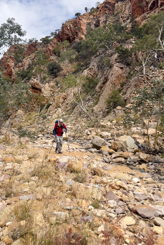
A rocky start to the day. Whenever the trail follows a watercourse or goes through a gap or gorge, you can expect this kind of surface — not a trail per se, just rocks in the creekbed with a correspondingly slow pace. Interestingly, our pace is always slower than most hikers, but not as much in this terrain, perhaps because there are fewer flowers to photograph!
Although some days you’ll be traversing rocks like this for many hours, today is only a short distance — in a few minutes you’ll leave the river onto much smoother track.

Where you went left yesterday up to Mt Sonder, today you go right. Faster hikers will likely skip Rocky Bar Gap and Hilltop, but slower hikers should definitely stop at one of them.

In this spot the fire has burned hot, with less regeneration than elsewhere.
You can also see that, even where it’s stony on these flatter areas, the track is much smoother and therefore significantly easier walking than the steep and elevated sections as you experienced yesterday, or the rocky watercourses. Factor this in when planning each day: the trail surface makes steep areas more demanding in addition to the fact that you are climbing or descending.

Eventually we reach the end of the fire-affected area and are into sheltered woodland, with pretty sub-shrubs scattered throughout.

Crimson Foxtail, Ptilotus sessilifolius.

Although buffel grass covers the flats, the dry rocky foothills here still have plenty of the endemic spinifex.
Although it looks friendly, spinifex is infamously spiky, easily penetrating pants and even lightweight gaiters. Fortunately, the track is sufficiently clear that we never felt we needed gaiters, though we were grateful for our long pants: we met a number of hikers in shorts and with scratched legs.

The mysterious unexplained event that created the West McDonnell Ranges has tilted the sedimentary rock, exposing the layers. Even in dull weather, the rich reds are stunning.

Second breakfast. You have many days ahead of you, so staying fuelled is important. These crunchy roasted broad beans are one of our favourites (especially the chilli flavour). They have about 1850kJ/100g, a little less than potato chips, but with much more protein (16g/0.56oz). We have had roasted soy beans which are even better nutritionally, but haven’t found them recently.

Remember that flat 200km/124mi drive to Redbank Gorge? You’ll traverse plains later, but most of your hike is through much more varied terrain, with fascinating landforms: geologists LOVE the Larapinta! The hard siliconised sandstone layer resists erosion and ends up capping the ridgetops and peaks whilst the softer layers are eroded away; Anett Weisheit’s book ‘Behind the Landscape of the Central Ranges’ is an excellent guide for non-geologists. This hard stone is significant for high camps, as you’ll see later!

Without harsh sunlight to wash them out, the greens and grays separate into multiple subtle shades.
We had been told that the Larapinta was varied, but the image of the flat plains around Uluru stuck in my mind. Even reading “Macdonnell RANGE” on every map, and seeing those contours, didn’t budge that misconception and it is only now that we are beginning to absorb that this trail is going to be completely different — wonderfully different! — to what we expected.
When looking at our images, check the trail itself. I often take pictures not to show flashy views, but to indicate general trail surfaces, to give you an idea of what the day holds.

If you hike at our speed, you are likely to arrive at Rocky Bar Gap Campsite around lunchtime (it took us four hours). Rocky Bar Gap has a toilet, table and water tank, but no hut. The pretty gap is a five minute walk from camp so, if you stay here, you could have dinner near the waterhole, and watch wildlife arriving to drink at dusk.
Faster E2W hikers coming from Finke River campsite are here at lunchtime too, so it will be congenial. A group of nurses is at the table — surprising how many nurses we meet on trails! — plus solo hikers, and other small groups. None are planning to stay at Rocky Bar Gap.
Now is the time for you to assess whether to continue to Hilltop campsite — Finke River Camp is out of reach for slower hikers — or whether to stop here. Remember, you aren’t locked into a fixed itinerary. You have spare days at the end with booked accommodation in Alice Springs in three weeks time that you have plenty of oppurtunity to change. Once you free yourself from the idea of a fixed itinerary — an idea that’s locked into guided tours — there’s a shift change.
On very long thru-hikes like the Bibbulmun in Oz, and even longer hikes in the US like the PCT, CDT and AT, you quickly realise that you can make your accommodation fit your schedule, rather than you fitting it. It is an epiphany and totally changes the way that you hike. Even on hikes without scheduled paid accommodation, you realise that you’re carrying everything that you need on your back. You can stop when you need to, regulations permitting. It is incredibly liberating and empowering.
Hilltop Campsite is another 4.7km/2.9mi, and you have 350m/1150ft elevation gain. You have just hiked 11.1km/6.9mi.
Remember your climb yesterday: Hilltop is half that elevation but steeper being over only a quarter of the distance (so twice as steep). Will this be comfortable for you? Your less strong partner? This is the kind of comparison and calculation that allows you to tailor every step of this hike to your specific hiking pace and ability. Stay flexible. If you think that you’ve had enough for the day, stay put: you’ll have a climb tomorrow morning when you are fresh and rested, followed by a downhill and flats over a distance similar to today. But if you really like the idea of that spectacular elevated campsite with its view of Sonder, you may prefer to keep going. You have all afternoon to get there!
If it’s very windy, stop at Rocky Bar Gap: even in light winds as when we camped, Hilltop — like many of the high camps on the Larapinta — is in an acceleration zone, so subjected to higher windspeeds than nearby areas.

Sheltered campsites at Rocky Bar Gap…

…but we decide to continue, here approaching Rocky Bar Gap itself.

A small still pool remains in the gap, sheltered by River Red gums.

And here is the rocky substrate that’s present in every gorge and gap.
Pure white-trunked ghost gums(Corymbia aparrerinja) find a foothold in the rocky cliffs…

…and, because of the recent rain, Wickam’s Grevillea (G. wickhamii) is in full bloom in the gap.

Emerging from the Gap into buffel grass on the northern side of the range. A campsite is marked on the official trail map here; we forgot to check for it, but in this photo I can see tell-tale rocks in the copse of trees on the right, and some bare areas with more rocks on the left.

The climb begins, very gently at first. Remember to look behind you for views of Mt Sonder.

The trail quickly becomes steeper and rockier...

… and steeper yet! There are a few switchbacks to make the climb a little easier and, even after this burn, small flowering plants tucked amongst the rocks. How incredibly tough they must be to survive here!

And finally you reach the top: phew! Oh, but it’s worth it for that view of Sonder: wow!
We see about eight campsites scattered across the hill; Chapman says there are “numerous” sites so we missed a few. Some were amongst bushes but nearly all are extremely exposed, and some will be less protected in certain wind directions. As a slower hiker, you can expect that the most sheltered sites are likely to have been taken by the time you arrive, so a solid knowledge of anchoring techniques is worthwhile.
In the picture above, the wind is coming from the left, and we raised the rock wall and use the peak guyline on that side. Although the campsite is cleared, you can see just how rocky the hill is, with not only scattered stone, but also deeply embedded slabs. It was impossible to insert any stakes and again we used the modified deadman technique. Tents can be tricky to erect in wind, especially if you’re unfamiliar with yours, so practise at home first and know the tricks and tips for success, so that your tent doesn’t blow away while you are rummaging in the bag for stakes!
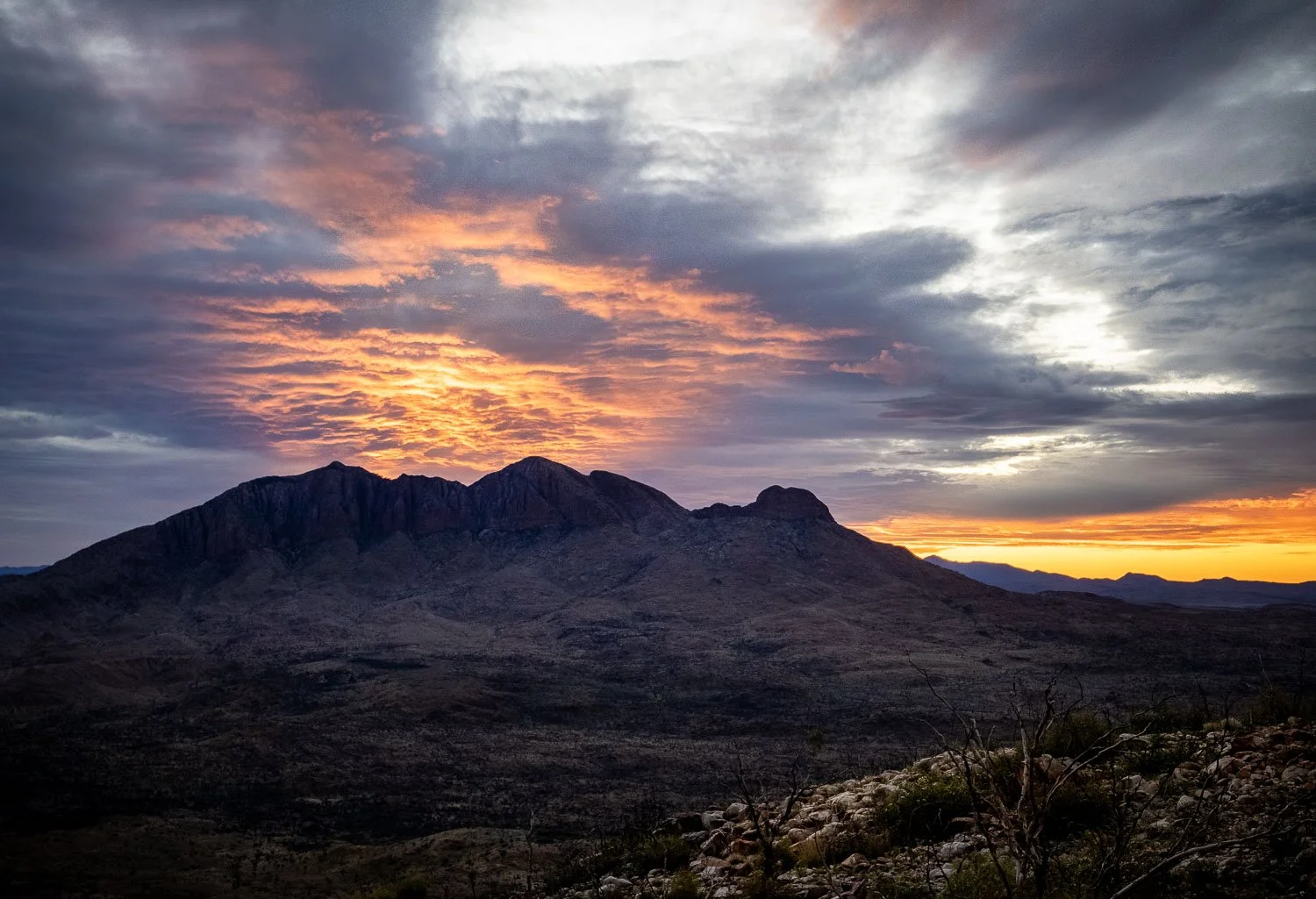
A spectacular sunset behind Mt Sonder certainly whets the appetite for what the sunrise will bring: we just can’t wait!
We respectfully acknowledge the Arrernte People as the traditional custodians of the land on which we walk and pay our respects to Elders past and present and to the Aboriginal people present today.